
MASSACHUSETTS has thousands of beaches - no way did I have time to check them all so I confined myself to some on CAPE COD, MARTHAS VINEYARD and NANTUCKET. I tried to concentrate on those beaches the reviews said were above average.
AREA COVERED

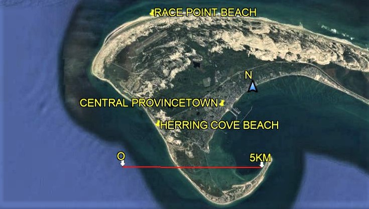
NANTUCKET ISLAND is abt 25m/40km offshore from HYANNIS.
MARTHAS is 20m/30km although parts of it are much closer to CAPE COD.
** NOTE BOSTON is in the wrong place on this image - that's just south of PROVIDENCE RI. BOSTON is out of image slightly top right. Correcting the map is very time consuming and I'm feeling lazy - so sue me.
CAPE COD

There are 15 towns on the Cape although with a tight dance-card I confined my time to HYANNIS and PROVINCETOWN.
The Cape is famous in history as the place of first landing by the PILGRIMS (at PROVINCETOWN) although European visitors go much earlier - there are several documented visits by PORTUGUESE navigators, plus rumoured calls-ins by THE VIKINGS.
Once again BOSTON above is shown in the wrong place - it should be out of image top centre/left.
Labels may be clearer if you can click-expand image.
HYANNIS BEACHES
I based myself in HYANNIS. It has several beaches in town, the most noteworthy below:

Note how well the inner harbour is protected first by LEWIS BAY (the main body of water on the image) which in turn is protected from the open ocean (sometimes referred to as NANTUCKET BAY) at the foot of image. It's no mystery why HYANNIS became a major harbour last century.
Famous HYANNIS PORT which was the summer hangout of the KENNEDYS starts west of that N-S line (which is actually SEA ST) at image far west and goes out of image. "PORT" is a bit of a stretch - a long breakwall (bottom left dark) does give shelter from the ATLANTIC swells to small craft but is a bit exposed for bigger vessels. Maybe back in the day.......
As you can see, there's lots more strips of sand around LEWIS BAY, the INNER HARBOUR and the ATLANTIC COAST bottom left, but my dance card was kinda full and I didn't make them.
VETERANS PARK BEACH
 VETERANS PARK BEACH is the strip of sand from image top to YACHT CLUB pier, a distance of abt. 280m. The park area is between the beach and N-S road (OCEAN ST) - that vividly white area towards the south end of the park is actually a new concrete extension of the car park which also stretches north immediately behind the sand. The KENNEDY MEMORIAL PLACEMARK is at top - might be worth click-expanding image to make labels clearer. The KOREAN WAR MEMORIAL is in those trees back of center beach.
The beach below the yachting pier is private to club and condo people.
This is a beach best suited to families with little kids and non-swimmers on account it's position on protected LEWIS BAY means open ocean swell seldom penetrates so there is no need to worry about tricky waves and associated rip-currents 99% of the time. The bay also has very shallow water so it is possible for people to wade far from shore. All the same, keep a close eye on kids (despite lifeguards in summer) - they can get into trouble so quickly, even in benign areas. One other thing about the isolation from the open ocean and the shallowness - the water seemed a few degrees warmer than open ocean beaches nearby.
Sand tends to be more tan-yellow than white with quite a lot of shells and small pebbles near the water. In the water the stones continue - mostly rounded so no trouble for waders.
 VETERANS BEACH from the north end - not narrow and uncrowded 11AM on a nice week day about a fortnight before LABOR DAY. Note YACHT CLUB in background with pier out into bay to the left.
 VETERANS BEACH from the south end.
THE PARK AREA
This grassed and treed area is not small, occupying a 280x130m area between the beach and OCEAN ST. In the north it contains the JFK MEMORIAL, central treed areas contain the KOREAN WAR MEMORIAL, plus there is a kids' playground, change areas, a food outlet, lifeguards' building and numerous picnic tables and benches. There are a couple of grills.
 The JFK MEMORIAL was restrained and well worth a visit.
 North end of VETERANS BEACH and LEWIS BAY from the JFK MEMORIAL That's the NANTUCKET VEHICLE FERRY heading towards the even more protected INNER HARBOUR about a km north
 War memorials always move me - make me feel how lucky my life has been.
My camera ran out of battery so I had to pinch this one from CAPE COD PHOTO ALBUM via good old GOOGLE IMAGES.
ACCESS
The beach and park are a walkable distance south along OCEAN ST of the popular HYANNIS INNER HARBOUR, MAIN ST AREA and not much further from the regional bus center (HYANNIS TRANSPORT CENTER). They are also on the route of the handy HYANNIS TROLLEY which does a free circuit past HYANNIS' main attractions every 45 minutes from the TRANSPORT CENTER. Will put down/pick up wherever safe. The beach/park are about 70% into the anticlockwise circuit.
There is a big parking lot behind the sand - unfortunately the cost is $20 irrespective of time spent (although if you are keen you can use the parking ticket at 3 other BARNSTABLE area beaches the same day). The good news is that walk/cycle-ins enter free. There is also a smaller half hour lot adjacent the JFK MEMORIAL for people wanting to check the sand or the memorials.
 The free HYANNIS TROLLEY goes past VETERANS BEACH
SUM UP
I kinda enjoyed my two visits here, not so much for the beach which is pretty ordinary by great beach standards, (although if I had a few kids in tow I would have thought differently), but because of the MEMORIALS and the general park area which is a great place to relax after the walk down from town.
KALMUS BEACH
This is actually a TWIN beach, being located on DUNBAR POINT SPIT at the entrance to LEWIS BAY, about a km further south than VETERANS BEACH. Spits usually have beaches both sides, so here we are talking KALMUS BAY SIDE - and less than 200m south on the other side of the spit, KALMUS OCEAN SIDE.
KALMUS BAY SIDE AND OCEAN SID BEACHES.
 This area is less than 2km south along OCEAN ST (far left of image) from the busy HYANNIS INNER HARBOUR and not much futher to the main street and bus station (HYANNIS TRANSPORT CENTER). It is also on the HYANNIS TROLLEY route which is a good option seeing the big parking lot charges $20 irrespective of duration - walk or cycle-ins FREE. I walked down from the harbour area one visit - didn't take too long and VETERANS PARK (up page) is a good place for a rest about half way.
KALMUS BAY SIDE BEACH
 This is nicely protected from any brisk onshore sea breezes and ocean swell (with the associated rip currents) so is a good beach for families with little kids. The water tends to be fairly shallow and slightly warmer than the other side.
Sand was pretty ordinary - a grey shade of white with lots of shell fragments. Nice and wide here adjacent the access from the amenities block, narrower elsewhere. It stretches about 700m from LEWIS BAY entrance to right of pic to the HYANNIS YACHT CLUB far background.
Nice and sheltered from the brisk onshore sea breezes. There was not a big crowd this nice August week day.
I'd rate this beach very average unless I had little kids in tow.
 The wider section of KALMUS BAY SIDE adJacent access from the amenities block (white arrow).
KALMUS OCEAN SIDE

The south side beach seen from the entrance to LEWIS BAY. Note the weed - there were also lots of shells and stones in this area too. Breakwall in foreground stretches right across the entrance and bookends BAY SIDE beach too - popular with people fishing and after a view.
 KALMUS OCEAN SIDE is slightly longer and a fair bit wider than the bay side beach. My visits saw strong onshore sea breezes which made things a bit unpleasant - hence few people on the beach. However it may be the place to head for on those really hot summer days when there is a bit of a sea breeze around.
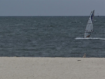 However the breezy conditions where just the ticket for about half a dozen wind-surfers. They no doubt rate this beach way above my BARELY AVERAGE.
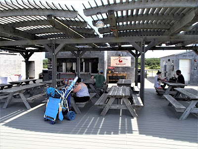
 Big AMENITIES BLOCK is mid-spit, halfway between each beach. Contains change sheds, lifeguards' area, a small museum like section, and a food outlet with a big undercover seating section which you can see at its left.
PROVINCETOWN BEACHES
PROVINCETOWN in the far north of Cape Cod is a hell of a long way from HYANNIS but according to my research, has some of the best beaches on CAPE COD. So I jumped on a series of buses and slowly made my way up to the far northern area of the Cape. When I arrived I found the annual GAY PRIDE PARADE was on that day, and that the trendy town was crowded with an estimated 100,000 visitors, good fun but making regular transport out to the nearby beaches a bit disrupted.
SOME GAY-PRIDE PARADE PIX

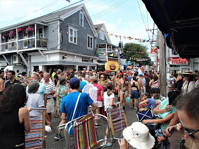


 Everyone likes fancy dress - it seems a lot of visitors both straight and gay decided to get in the mood of the celebration by dressing up outrageously and parading up and down main street for several hours before the main parade. Most of the above shots are pre-parade pix.
THE BEACHES
There are lotsa beaches in this area - actually the beach in town is not too bad - but the two which get the rave reviews are HERRING COVE BEACH and RACE POINT BEACH.
 Each beach is a few kms out of town, HERRING COVE the closer. Access is no problem with big parking areas and a connection by modestly priced beach shuttle bus which does a circuit every 30 or 60 minutes (see online schedule). Actually there are 2 shuttles - the NORTH TRURO one goes to places on the far right of these images (bigger buses from the south don't stop the PROVINCETOWN side of TRURO VILLAGE on safety grounds). Cycling is also big in this area and a popular way to access beaches. Shuttles have bike racks if you are feeling lazy on return.
Each beach is part of the CAPE COD NATIONAL SEASHORE - a national park set up by JFK to protect north-east CAPE COD from development. This ranges over 40m/64km of the eastern and northern CAPE COD ATLANTIC COAST, wrapping around the northern most point (in shot) and heading down the west facing CAPE COD BAY to the tip of the hook adjacent the 5KM marker. You have more or less a continuous strip of sand along this distance. Sand dunes back the beach in many places, not least the northern sections in this image.
RACE POINT BEACH


Being a section of a 64km long strip of sand, RACE POINT is not short of length. And it is plenty wide from the high tide mark in shot to the dunes in back. Sand was nothing special - reviews talked of white sand but it was struggling to make off-whit my visit and there was a fair bit of shell grit and small stones at the high water mark.
 Access is via a 100m path thru the dunes from the parking area. Have footwear, that rubber paving can get hot.
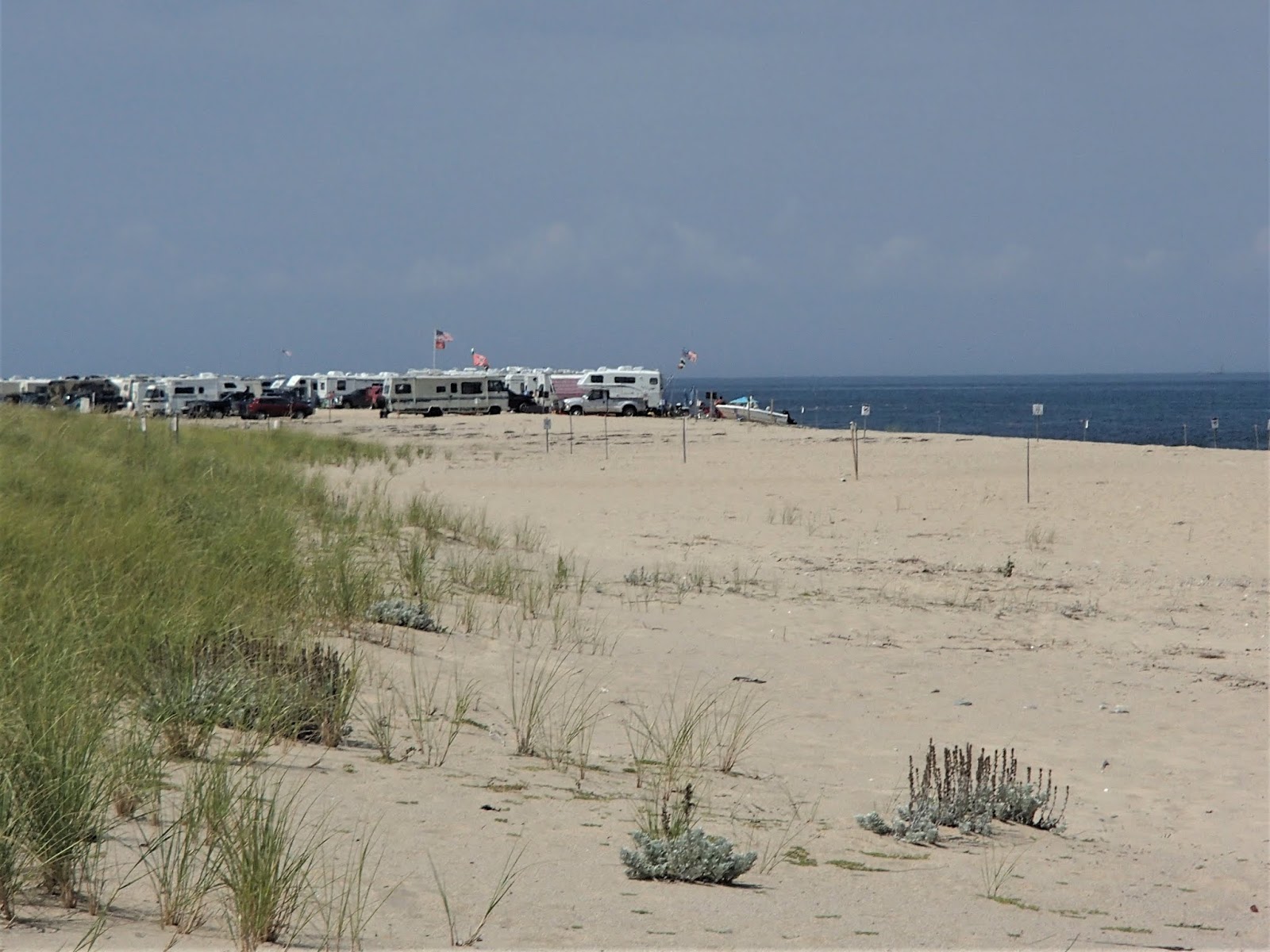
 RVs had taken over the beach about 300m north - GOOGLE MAPS shows and access lane.
 Dunes covered with the usual featureless dune grass.
 Wouldn't be the LAND OF THE FREE without the usual restrictive signage.
 RACE POINT BEACH has a big parking area - cost is $15 a day. Rear left is the change shed area - there was also a food van doing good business back there. Note beach wheelchair - a mobility-impaired person arrived and lifeguards produced this neat gadget to take them to their place of choice down on the beach. This is something Australian life-savers don't provide. Neat.
 Just when you thought it safe to go into the water....
RACE POINT BEACH COURTESY GOOGLE EARTH

MY RATING - this is not a bad beach but is nothing special - overall I'd rate it AVERAGE.
Which brings me to TRIPADVISOR reviewers' ratings - of the 1400+ about this beach at the time of writing only 4% agreed with my AVERAGE rating. Fully 73% thought it EXCELLENT with another 21% at ABOVE AVERAGE.
Which leads me to the conclusion that a lot of reviewers don't know what they are talking about - many attend a beach once a year when on holiday and to them any cleanish strip of sand with sparkling blue water is excellent. And then there are others who use the ratings system as AN AFFIRMATION OF THEIR INFALLIBLE TASTE - they selected this beach, so of course it's excellent. Finally we have a bunch of very experienced beachgoers who prefer these big open rather featureless beaches, Fair enough that they rate them higher than me - but heck: EXCELLENT? I've seem many way better examples of this type of beach. So I think most of these experienced big wide beach lovers would be rating one step down from EXCELLENT at ABOVE AVERAGE/VERY GOOD.
HERRING COVE BEACH
This is the second of PROVINCETOWN''s beaches the reviews rave about as being something special (70% rated EXCELLENT - say what?) - but I was disappointed; to me this beach was not bad, not extra good - AVERAGE by world standards.
 HERRING COVE SOUTH - typical of the beach here, definitely narrower: probably not as aesthetically pleasing as RACE POINT - but there are other pluses which lift it to a similar level.
 HERRING POINT NORTH - the parking area extends to the north which allows beach-goers to extend much further along the beach than RACE POINT. Arrow point at entrance to a rather big mid dune lagoon/swamp called "HATCHES HARBOR" - the entrance was kinda shallow and was proving a great place for kids. Be aware these places change over time. CAVEAT: this area is at least 1KM/600yards north of the beach entrance, but way less if you manage to score one of those northern parking spots.
 HERRING POINT SOUTH - note the rocks. I also say some lumps of tar-like dumped boat bunker fuel - dumping this is illegal but proof? Lotsa passing boats of all sizes. Fortunately it was not widespread. UPDATE AUGUST 2020 - "Fitguy" saw my tar remarks on a review I did for TRIPADVISOR and messaged me that the tar is actually the remnants of the old parking lot which was destroyed by a storm a few years back. Good to know.
VETERANS PARK BEACH

The beach below the yachting pier is private to club and condo people.
This is a beach best suited to families with little kids and non-swimmers on account it's position on protected LEWIS BAY means open ocean swell seldom penetrates so there is no need to worry about tricky waves and associated rip-currents 99% of the time. The bay also has very shallow water so it is possible for people to wade far from shore. All the same, keep a close eye on kids (despite lifeguards in summer) - they can get into trouble so quickly, even in benign areas. One other thing about the isolation from the open ocean and the shallowness - the water seemed a few degrees warmer than open ocean beaches nearby.
Sand tends to be more tan-yellow than white with quite a lot of shells and small pebbles near the water. In the water the stones continue - mostly rounded so no trouble for waders.


THE PARK AREA
This grassed and treed area is not small, occupying a 280x130m area between the beach and OCEAN ST. In the north it contains the JFK MEMORIAL, central treed areas contain the KOREAN WAR MEMORIAL, plus there is a kids' playground, change areas, a food outlet, lifeguards' building and numerous picnic tables and benches. There are a couple of grills.


My camera ran out of battery so I had to pinch this one from CAPE COD PHOTO ALBUM via good old GOOGLE IMAGES.
ACCESS
The beach and park are a walkable distance south along OCEAN ST of the popular HYANNIS INNER HARBOUR, MAIN ST AREA and not much further from the regional bus center (HYANNIS TRANSPORT CENTER). They are also on the route of the handy HYANNIS TROLLEY which does a free circuit past HYANNIS' main attractions every 45 minutes from the TRANSPORT CENTER. Will put down/pick up wherever safe. The beach/park are about 70% into the anticlockwise circuit.
There is a big parking lot behind the sand - unfortunately the cost is $20 irrespective of time spent (although if you are keen you can use the parking ticket at 3 other BARNSTABLE area beaches the same day). The good news is that walk/cycle-ins enter free. There is also a smaller half hour lot adjacent the JFK MEMORIAL for people wanting to check the sand or the memorials.

SUM UP
I kinda enjoyed my two visits here, not so much for the beach which is pretty ordinary by great beach standards, (although if I had a few kids in tow I would have thought differently), but because of the MEMORIALS and the general park area which is a great place to relax after the walk down from town.
KALMUS BEACH
This is actually a TWIN beach, being located on DUNBAR POINT SPIT at the entrance to LEWIS BAY, about a km further south than VETERANS BEACH. Spits usually have beaches both sides, so here we are talking KALMUS BAY SIDE - and less than 200m south on the other side of the spit, KALMUS OCEAN SIDE.
KALMUS BAY SIDE AND OCEAN SID BEACHES.

KALMUS BAY SIDE BEACH

Sand was pretty ordinary - a grey shade of white with lots of shell fragments. Nice and wide here adjacent the access from the amenities block, narrower elsewhere. It stretches about 700m from LEWIS BAY entrance to right of pic to the HYANNIS YACHT CLUB far background.
Nice and sheltered from the brisk onshore sea breezes. There was not a big crowd this nice August week day.
I'd rate this beach very average unless I had little kids in tow.

KALMUS OCEAN SIDE

The south side beach seen from the entrance to LEWIS BAY. Note the weed - there were also lots of shells and stones in this area too. Breakwall in foreground stretches right across the entrance and bookends BAY SIDE beach too - popular with people fishing and after a view.


PROVINCETOWN BEACHES
PROVINCETOWN in the far north of Cape Cod is a hell of a long way from HYANNIS but according to my research, has some of the best beaches on CAPE COD. So I jumped on a series of buses and slowly made my way up to the far northern area of the Cape. When I arrived I found the annual GAY PRIDE PARADE was on that day, and that the trendy town was crowded with an estimated 100,000 visitors, good fun but making regular transport out to the nearby beaches a bit disrupted.
SOME GAY-PRIDE PARADE PIX


THE BEACHES
There are lotsa beaches in this area - actually the beach in town is not too bad - but the two which get the rave reviews are HERRING COVE BEACH and RACE POINT BEACH.
Each beach is part of the CAPE COD NATIONAL SEASHORE - a national park set up by JFK to protect north-east CAPE COD from development. This ranges over 40m/64km of the eastern and northern CAPE COD ATLANTIC COAST, wrapping around the northern most point (in shot) and heading down the west facing CAPE COD BAY to the tip of the hook adjacent the 5KM marker. You have more or less a continuous strip of sand along this distance. Sand dunes back the beach in many places, not least the northern sections in this image.
RACE POINT BEACH


Being a section of a 64km long strip of sand, RACE POINT is not short of length. And it is plenty wide from the high tide mark in shot to the dunes in back. Sand was nothing special - reviews talked of white sand but it was struggling to make off-whit my visit and there was a fair bit of shell grit and small stones at the high water mark.


RACE POINT BEACH COURTESY GOOGLE EARTH

MY RATING - this is not a bad beach but is nothing special - overall I'd rate it AVERAGE.
Which brings me to TRIPADVISOR reviewers' ratings - of the 1400+ about this beach at the time of writing only 4% agreed with my AVERAGE rating. Fully 73% thought it EXCELLENT with another 21% at ABOVE AVERAGE.
Which leads me to the conclusion that a lot of reviewers don't know what they are talking about - many attend a beach once a year when on holiday and to them any cleanish strip of sand with sparkling blue water is excellent. And then there are others who use the ratings system as AN AFFIRMATION OF THEIR INFALLIBLE TASTE - they selected this beach, so of course it's excellent. Finally we have a bunch of very experienced beachgoers who prefer these big open rather featureless beaches, Fair enough that they rate them higher than me - but heck: EXCELLENT? I've seem many way better examples of this type of beach. So I think most of these experienced big wide beach lovers would be rating one step down from EXCELLENT at ABOVE AVERAGE/VERY GOOD.
HERRING COVE BEACH
This is the second of PROVINCETOWN''s beaches the reviews rave about as being something special (70% rated EXCELLENT - say what?) - but I was disappointed; to me this beach was not bad, not extra good - AVERAGE by world standards.


Sand was closer tan-yellow than the white many reviews mentioned. ARROW points towards nude area: apparently there are LESBIAN and GAY areas betweenn - life guards told me nude area is abt 1km south - I'm a naturist but was not prepared to walk this just to see another nude beach. So shoot me.
BUT HERE'S THE THING - I thought the lateral stratification of the beach - TEXTILES/LESBIANS/GAYS/NUDES was a PLUS over RACE POINT which was a much more concentrated textiles only area.
Another PLUS was the food outlet - in place of the FOOD TRUCK with deficiency of seating at RACE POINT, here we have a full service outlet with way more eats then fries/soda (even went to wine in cans) and lotsa sit down areas under shade.
HERRING POINT BEACH FOOD OUTLET
HERRING COVE LIFE GUARDS
 As can be seen, these dudes had a pretty easy task on the day I visited when surf conditions were very benign. But don't be fooled - little kids can get into trouble so quickly even in the calmest of conditions and those dudes in shot may be distracted by those hot co-eds in the G-strings: I know every male on the beach except cool-hand TEZZA was. If someone gets into trouble alert the life-guards: they have the surf/rescue knowledge and endurance which the average dude hasn't. I don't wanna think about the number of people drown when trying to help others in trouble.
 The beach shuttle - this starts in town and does a circuit which includes HERRING COVE and RACE POINT on a 30/60mins schedule (look online - my day was complicated by route changes in town due to the parade).
Arrow points to receptacle where passengers put $10 NATIONAL PARK ENTRANCE fee. A bit stiff if like me you just wanna check the beach, not stay any length of time.
Shuttle has bike racks for people who dont wanna ride back to town (PROVINCETOWN is very big on bike rentals). This brings up another plus of this beach over RACE POINT - closer to town and with few sand-dune gradients.
OVERALL - once again I thought this was an okay beach, but nothing to get excited about. Aesthetically is is not quite as good as RACE POINT,but has the advantages of closer to town, more diversification and a much better food outlet. However these were not enough to drag it higher in my rating - I also give this one an AVERAGE rating - albeit a bit higher than RACE POINT.
THOSE SUNSETS - I didn't stay for sunset. But from reader reviews, I get the idea that this west facing beach does those pretty well. So if I was judging solely from the point of view of being a sunset beach, maybe my rating may be higher than AVERAGE.
 I had to borrow this pic from PINTEREST/PROVINCETOWN
HERRING COVE BEACH AREA

NANTUCKET ISLAND

This small island (4.5m x14m/7km x 23km) is abt 30m/48km south of Cape Cod. It is the outward remnant of an ice age out-wash plain, isolated from the mainland by sea level increase. As such it is pretty flat with few hills. There are quite a lot of small lakes which were formerly big ice lumps in the sandy/gravelly outwash. Plenty of island and offshore sand has contributed to beach construction - and so we have a more or less continuous strip of sand from the western-most point, along the south coast up to the north-east point of the island (42km/25mi) - -past here heading west again along the north coast is much the same with a few interruptions for inlets and bays. If a BARRIER BEACH is an offshore beach (maybe connected to the mainland in a few spots) behind which is a lagoon-like area, I guess the eastern half of the north coast fits. Confusingly, most of the rest seems similar to barrier beaches I know - long, featureless, backed by low dunes (although there are also low cliffs in the north east and along parts of the north coast).
Parts of the island not settled (there are a few villages apart from NANTUCKET TOWN, of which SIASCONET is probably the largest) are covered by the type of forest and scrub not fussed by the sandy soil and are reasonably attractive. Sandy soil was and is a big barrier to any meaningful agriculture on the island. Whaling on the other hand.....
I think NANTUCKET is reasonably attractive. It looks good, has a lot of interesting history which the locals have preserved nicely, some small very attractive towns and the beaches are not bad. At the same time, I think this place has been over-hyped in the same way THE HAMPTONS on LONG ISLAND have - there is too much money chasing nice spots in NE USA which had elevated these pretty good places way too much. In no way do the beaches, towns etc meet the "EXCELLENT" rating so many TRIPADVISOR reviews give them. In truth, most GREEK ISLANDS would blow NANTUCKET out of the water when it comes to landscape, villages, history, killer beaches. But NYC people can fly to NANTUCKET in 90mins and drive/ferry under 5 hours - way fewer than the GREEK ISLANDS.
Um....the CARIBBEAN islands are way closer.
SURFSIDE BEACH
 SURFSIDE is part of the seemingly endless strip of sand on NANTUCKET's south coast. The majority of beach-goers were concentrated on the sand around the scale line/near where the access track from PARKING arrived.
Yellow arrow represents HOSTELING INTERNATIONAL NANTUCKET, where a dorm bed cost me a fraction of the average nosebleed holiday accommodation tariff. NANTUCKET is an expensive island. Seems like I'm gloating about the accommodation deal I got - well price-wise I am, but in terms of the usual HOSTELING INTERNATIONAL HOSTEL it was kinda disappointing.
SUNSET OPPOSITE THE ARRIVAL TRACK
 This is a fairly popular beach, as seen by the crowd close to the access track from the carpark/amenities. The sand is not exactly that blinding white the NANTUCKET publicity bits talk about, but at least nice and wide here from the high tide mark to the start of the dunes - length is indeterminate stretching off towards the horizon for miles but further sections are given different names eg FISHERMANS BEACH to the east and MIACOMET to the west but don't ask me where the boundaries are.
Surf was benign the days I visited but this beach faces the open ATLANTIC and at times gets quite big swell - with associated dangerous surf and rip currents. Surfer dudes would love this - others less so. Fortunately life-guards are provided.
 The beach is backed by up to 200m of low dunes with the usual dune grass. I find such back-drops pretty boring. The longish access path has more than its fair share of gravel and sharp grass seeds plus gets a bit hot under the sun - footwear recommended.
That's the AMENITIES block background right - the PARKING AREA starts to the left. This is very large - hourly buses from town terminate in the area close to the access path above.
 This is THE BEACH SHACK - containing dressing sheds/showers far end and a food outlet closer to camera. I was not real impressed with the exxy prices at the outlet, and my hamburger was pretty mushy too. There is a taco truck around the back (no bargain) and some picnic tables but not a lot of seating near camera.
 About 600m west an access track allowed these off-roaders to hold a tailgate parties on the beach. This apparently is pretty popular on the island and is about the only use in 4WD these vehicles get. Not sure if this is still SURFSIDE or has some other name - is a bit short of MIACOMET.
 In the other direction, I could see a smaller crowd about 400m east of the main group 4 pix up page, no doubt where some main access track or road hits the beach.
This shot gives some idea of the endless nature of NANTUCKET's southern beach. I find it boring but some people love these wide open, unlimited beaches. Others see only one beach a year on holidays on naturally think it's the best beach in the world. Plus as I've pointed out elsewhere, some people reckon whatever beach/restaurant/attraction they pick is automatically totally excellent and use the ratings system on review pages as an affirmation of their infallible taste.
JETTIES BEACH
JETTY in NEW ENGLAND-speak means break- wall (all the places I know regard a jetty as a WHARF or PIER) and there are TWIN BREAK-WALLS adjacent this beach, lining the entrance to NANTUCKET CHANNEL, the entrance to NANTUCKET TOWN HARBOR
 ARROW points to the western "jetty" at this northern beach.
 Modified GOOGLE EARTH image shows location adjacent the entrance to the channel leading to NANTUCKET HARBOR. The beach at one stage must have been really narrow, but a section of the low sand dunes has been hollowed out to form a "cut" (WHITE ARROW) which provides quite a lot of extra flat sand for beach goers. Despite the surrounding dunes being fairly low, this area was surprisingly calm and warm given the strong cool north-east wind blowing my visit. SANDBAR RESTAURANT is in back of this "cut".
You can see the narrow beach also extends up the inside of the channel, but conditions that windy day were not nice there and there were few beach-goers in this area apart from a couple of fishermen.
JETTIES has quite big parking areas (P) behind which are some public tennis courts. A bus runs from this area the one mile into town every half hour or so. Only takes 10 minutes each way - waits outside the WHALING MUSEUM in town between runs.
 The "cut" - arrow shows SANDBAR RESTAURANT's good position at rear.
As can be seen, sand color aint exacty CARRIBEAN white. Has a fair few small stone pebbles closer the water too. Rubber matting gets pretty hot on sunny days - footwear recommended.

The "cut" from the alfresco dining terrace at SANDBAR
 More terrace. I like these areas although in true TEZZA style I spent most time inside, nursing a beer or three at the bar.
 Apart from the bar area, inside also had more dining tables (background-left). Whole area had a good vibe - helped by the old-style 70s/80s hits on the sound system.
I reckon NSW beaches are way better than anything in NE USA but are inferior in this area - our antiquated liquor licencing laws don't allow hard stuff to be sole at the beach. However in QUEENSLAND most surf clubs have a licence - and some have terrific beach views from their beer lounges.
 Bar close-up. Check TEZZA'S cool beer can holder bottom right.
 Traveled some distance. Don't ask how I got it.
 The SANDBAR building extended further west to include change/shower areas and this section selling surf wear and craft.
BACK TO THE BEACH
 Beach-goers braving the cooler wind in the mouth of the "cut". Note how the beach narrows down past the cut in background.
Note too the fairly benign surf despite the strong onshore wind - this beach faces the mainland which does not give enough distance for big swells to build up. So nasty surf and the associated rip currents would be pretty rare here - making it a good family beach. Despite this the beach has seasonal lifeguards.
People say these northern beaches have slightly warmer water than the ATLANTIC facing south coast beaches.
SUM UP - aesthetically this beach is no great shakes. Despite this, it was my pick of the various NANTUCKET beaches I visited. I thought the beach expansion and shelter afforded by "the cut" was a great improvement and I did enjoy the atmosphere at the SANDBAR. Convenience is a plus too - this beach is the closest open ocean beach to town, has a frequent and inexpensive bus service, lotsa parking etc. Has lifeguards and is a good family destination (although surfer-dudes will be underwhelmed). Finally unlike most NE US beaches it has kinda borders - the breakwall to the east and the narrow section past the cut (as seen in the above pic) to the west - and doesn't appear to stretch on forever.
NANTUCKET TOWN BEACHES
 CHILDRENS BEACH is tucked into the north-west corner of NANTUCKET HARBOUR only a few hundred meters from the ferry piers and downtown.
BRANT POINT is the prromitory where the incoming channel from the sea turns into NANTUCKET HARBOUR.
CHILDREN'S BEACH
 As can be seen, CHILDREN'S BEACH is pretty compact - the sand area only abt 100mx30. Behind is a park type area in the north and a smaller area to its south with change sheds, a food outlet and some picnic type seats and tables.
The beach has lifeguards and a netted enclosure - not a bad idea:anecdotally harbour areas a sharkier than most. Water clarity not bad but not as clear as open ocean beaches. Parking is pretty limited. Authorities put on kid-friendly activities during the summer.
BRANT POINT BEACH

EAST COAST NANTUCKET - SIASCONSET

WEST COAST NANTUCKET - MADAKET BEACH

BUT HERE'S THE THING - I thought the lateral stratification of the beach - TEXTILES/LESBIANS/GAYS/NUDES was a PLUS over RACE POINT which was a much more concentrated textiles only area.
Another PLUS was the food outlet - in place of the FOOD TRUCK with deficiency of seating at RACE POINT, here we have a full service outlet with way more eats then fries/soda (even went to wine in cans) and lotsa sit down areas under shade.
HERRING POINT BEACH FOOD OUTLET

HERRING COVE LIFE GUARDS


Arrow points to receptacle where passengers put $10 NATIONAL PARK ENTRANCE fee. A bit stiff if like me you just wanna check the beach, not stay any length of time.
Shuttle has bike racks for people who dont wanna ride back to town (PROVINCETOWN is very big on bike rentals). This brings up another plus of this beach over RACE POINT - closer to town and with few sand-dune gradients.
OVERALL - once again I thought this was an okay beach, but nothing to get excited about. Aesthetically is is not quite as good as RACE POINT,but has the advantages of closer to town, more diversification and a much better food outlet. However these were not enough to drag it higher in my rating - I also give this one an AVERAGE rating - albeit a bit higher than RACE POINT.
THOSE SUNSETS - I didn't stay for sunset. But from reader reviews, I get the idea that this west facing beach does those pretty well. So if I was judging solely from the point of view of being a sunset beach, maybe my rating may be higher than AVERAGE.

HERRING COVE BEACH AREA

NANTUCKET ISLAND

This small island (4.5m x14m/7km x 23km) is abt 30m/48km south of Cape Cod. It is the outward remnant of an ice age out-wash plain, isolated from the mainland by sea level increase. As such it is pretty flat with few hills. There are quite a lot of small lakes which were formerly big ice lumps in the sandy/gravelly outwash. Plenty of island and offshore sand has contributed to beach construction - and so we have a more or less continuous strip of sand from the western-most point, along the south coast up to the north-east point of the island (42km/25mi) - -past here heading west again along the north coast is much the same with a few interruptions for inlets and bays. If a BARRIER BEACH is an offshore beach (maybe connected to the mainland in a few spots) behind which is a lagoon-like area, I guess the eastern half of the north coast fits. Confusingly, most of the rest seems similar to barrier beaches I know - long, featureless, backed by low dunes (although there are also low cliffs in the north east and along parts of the north coast).
Parts of the island not settled (there are a few villages apart from NANTUCKET TOWN, of which SIASCONET is probably the largest) are covered by the type of forest and scrub not fussed by the sandy soil and are reasonably attractive. Sandy soil was and is a big barrier to any meaningful agriculture on the island. Whaling on the other hand.....
I think NANTUCKET is reasonably attractive. It looks good, has a lot of interesting history which the locals have preserved nicely, some small very attractive towns and the beaches are not bad. At the same time, I think this place has been over-hyped in the same way THE HAMPTONS on LONG ISLAND have - there is too much money chasing nice spots in NE USA which had elevated these pretty good places way too much. In no way do the beaches, towns etc meet the "EXCELLENT" rating so many TRIPADVISOR reviews give them. In truth, most GREEK ISLANDS would blow NANTUCKET out of the water when it comes to landscape, villages, history, killer beaches. But NYC people can fly to NANTUCKET in 90mins and drive/ferry under 5 hours - way fewer than the GREEK ISLANDS.
Um....the CARIBBEAN islands are way closer.
SURFSIDE BEACH

Yellow arrow represents HOSTELING INTERNATIONAL NANTUCKET, where a dorm bed cost me a fraction of the average nosebleed holiday accommodation tariff. NANTUCKET is an expensive island. Seems like I'm gloating about the accommodation deal I got - well price-wise I am, but in terms of the usual HOSTELING INTERNATIONAL HOSTEL it was kinda disappointing.
SUNSET OPPOSITE THE ARRIVAL TRACK

Surf was benign the days I visited but this beach faces the open ATLANTIC and at times gets quite big swell - with associated dangerous surf and rip currents. Surfer dudes would love this - others less so. Fortunately life-guards are provided.

That's the AMENITIES block background right - the PARKING AREA starts to the left. This is very large - hourly buses from town terminate in the area close to the access path above.


This shot gives some idea of the endless nature of NANTUCKET's southern beach. I find it boring but some people love these wide open, unlimited beaches. Others see only one beach a year on holidays on naturally think it's the best beach in the world. Plus as I've pointed out elsewhere, some people reckon whatever beach/restaurant/attraction they pick is automatically totally excellent and use the ratings system on review pages as an affirmation of their infallible taste.
JETTIES BEACH
JETTY in NEW ENGLAND-speak means break- wall (all the places I know regard a jetty as a WHARF or PIER) and there are TWIN BREAK-WALLS adjacent this beach, lining the entrance to NANTUCKET CHANNEL, the entrance to NANTUCKET TOWN HARBOR


You can see the narrow beach also extends up the inside of the channel, but conditions that windy day were not nice there and there were few beach-goers in this area apart from a couple of fishermen.
JETTIES has quite big parking areas (P) behind which are some public tennis courts. A bus runs from this area the one mile into town every half hour or so. Only takes 10 minutes each way - waits outside the WHALING MUSEUM in town between runs.

As can be seen, sand color aint exacty CARRIBEAN white. Has a fair few small stone pebbles closer the water too. Rubber matting gets pretty hot on sunny days - footwear recommended.

The "cut" from the alfresco dining terrace at SANDBAR


I reckon NSW beaches are way better than anything in NE USA but are inferior in this area - our antiquated liquor licencing laws don't allow hard stuff to be sole at the beach. However in QUEENSLAND most surf clubs have a licence - and some have terrific beach views from their beer lounges.


BACK TO THE BEACH

Note too the fairly benign surf despite the strong onshore wind - this beach faces the mainland which does not give enough distance for big swells to build up. So nasty surf and the associated rip currents would be pretty rare here - making it a good family beach. Despite this the beach has seasonal lifeguards.
People say these northern beaches have slightly warmer water than the ATLANTIC facing south coast beaches.
SUM UP - aesthetically this beach is no great shakes. Despite this, it was my pick of the various NANTUCKET beaches I visited. I thought the beach expansion and shelter afforded by "the cut" was a great improvement and I did enjoy the atmosphere at the SANDBAR. Convenience is a plus too - this beach is the closest open ocean beach to town, has a frequent and inexpensive bus service, lotsa parking etc. Has lifeguards and is a good family destination (although surfer-dudes will be underwhelmed). Finally unlike most NE US beaches it has kinda borders - the breakwall to the east and the narrow section past the cut (as seen in the above pic) to the west - and doesn't appear to stretch on forever.
NANTUCKET TOWN BEACHES

BRANT POINT is the prromitory where the incoming channel from the sea turns into NANTUCKET HARBOUR.
CHILDREN'S BEACH

The beach has lifeguards and a netted enclosure - not a bad idea:anecdotally harbour areas a sharkier than most. Water clarity not bad but not as clear as open ocean beaches. Parking is pretty limited. Authorities put on kid-friendly activities during the summer.
BRANT POINT BEACH

EAST COAST NANTUCKET - SIASCONSET

WEST COAST NANTUCKET - MADAKET BEACH

UM - MAYBE A FEW MORE THAN A FEW- IT'S NOW Oct 22 AND i'VE JUST COME HOME FROM A CRUISE. FINDING IT HARD TO GET MOTIVATED RE WRITING.


2 comments:
as i read your blogger, i found much information on it
Best Beaches in US
Really helpful
thank you for sharing this awesome article. i am also impressed to read
https://marketbusinesstech.com/famous-top-9-best-beaches-u-s-travel
it is the best and informative about the beaches in united states
Post a Comment