VISITED JUNE 2019
Sunrise just south of mainland LOMBOK's RINJANI VOLCANO from GILE GEDE (late June - sun will move rigtht until late December).
Gili means "small island". LOMBOK has hundreds - the best known are the NORTH WEST GILIS of TRAWANGAN, MENO and AIR but others offer holiday possibilities, the SOUTH WEST GILIS (aka "THE SECRET GILIS") among them.
LOCATION
I've long checked out the small islands off LOMBOK's south west peninsula from those creaky slow vehicle ferries out of PADANGBAI in BALI when cruising towards west LOMBOK's main west coast ferry port of LEMBAR - on hearing there is now a fast boat connection from Bali's KUTA I decided it was time to check some out. The fast boat lands at GILE GEDE - I spent 6 nights there split by 4 on neighbouring GILI LAYAR
GEDE and LAYAR
GEDE and tiny LAYAR are quite close to the mainland whose main departure point is the small fishing town of TEMBOWONG.
----------------------------
GILI GEDE
Seen here from slightly north of west, GEDE is about 4km long and averages 0.8km across. The near peninsula (which actually stretches west) is about 1km long. Total island circumference 13km. There are 3 lakes/lagoons/swamps (arrowed) - 2 tidal. That's the mainland top right.
GEDE (here from the north-east) is quite hilly - as a matter of fact people from flat countries might say some higher areas are small mountains. Note I have cranked in some vertical exaggeration to show the relief - nevertheless no way is this a flat island.
VILLAGES
GEDE has a few thousand people spit between 5 villages and a handful of smaller settlements. Central-west PEGAMETAN is largest, followed by TANJUNGAN far south-east. Locals are Muslim so no dogs, surprisingly few cats (maybe they aren't compatible with the free range chickens). No cars, some motos. Main activities are fishing, cattle, goats and chickens with tourism increasing in importance.
The arrival pier for the fast boat is in the central east's ORONG BUKAI which is joined to PEGAMETAN by a 300m path with houses all along. Don't ask where one village stops/other begins.
Each village has a mosque. They are close enough that the 5am call to prayers becomes an overlapping chorus - even better in the south when the 2 nearest mainland mosques join in.
EXPLORING THE ISLAND
At 13km around it's too big to do in one hit, especially on my worn out painful knees, so I did the NORTH HALF one day, the SOUTH HALF the next.
NORTH HALF
Tracks once went almost right around but a lot of disruptive building activity in the west saw me walking the beach past the NE corner down to PEGAMETAN. I went anticlockwise from ORONG BUKAI - took 2.5hours for the full circuit - good knees may almost halve this.
Only 5 minutes north of the ORONG BUKAI pier I found the tidal entrance to the NE lake/lagoon (see lake pic from viewpoint down page) - crossing done on this hand-line punt: easy.
VILLA SELALU's beach club is at the north east corner - beach better than average here (groomed). They have done a good job cleaning up the area behind the beach - more like a park than the typical scrub.
Cool beach park sculpture
The villa is high on the hill behind the north-east corner.
NORTH COAST
GEDE's north coast is nothing to write home about - the usual narrow beach with lotsa reef debris and (in back of the sand at the high tide mark) flotsam and jetsam.
There is a big coral reef offshore - at lower tide it is pretty exposed and was a popular fossicking place for locals and (at weekends) visiting mainlander,
WEST COAST
GEDE's west coast beach (seen here from GILI LAYAR's viewpoint) looks ok but has the typical narrowness, beach debris and rubbish back of beach.
There are a couple of beach houses behind the sand on the west coast - not sure of access, maybe by boat.
Half way down the west coast is this enty/exit to the NW lake/lagoon/swamp - lake not tidal (check the low dam wall white arrow) but foreground IS and would be a bit hard to pass with dry footwear top quarter of the tide. Section to left of image had a lot of beach scrub to traverse (the beach ran out for about 200m), good footwear recommended.
BEACH END
The west coast beach ends top left at the eastern end of PEGAMETAN village - actually it turns across in front of the village (arrow) but is even narrower and dirtier + there's lotsa fishing boats on the sand.
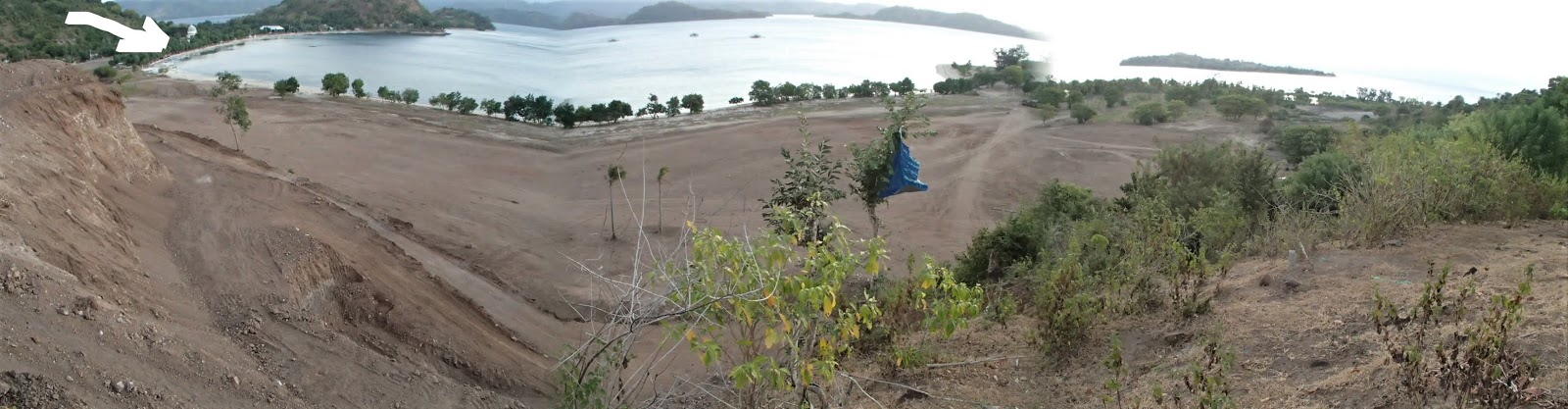
Note CLEARED AREA foreground - a Singaporean company was filling an ex-swamp with spoil from the hillside close-left. The plan is to build a MULTI BED RESORT. (see CONSTRUCTION CAPERS down page).
From east PEGAMETAN I took the short path left out of image across the low saddle to my starting place at ORONG BUKAI pier where I arrived 2.5 hours after departure. Will take you less.
SOUTH HALF
Paved paths go just about all the way around the southern half. I started at ORONG BUKAI pier just out of image top right, walked the gap around the CAMPING HEADLAND rocks (yellow arrow), picked up the track again and because the tide was up, walked around the INLAND SIDE of the SE lake/lagoon/swamp (at lower tide levels it is possible to walk the beach east side of lake and wade across the mouth of the lagoon [purple arrow])
I continued on the path thru LABUAN CENIK and TANJUNGAN villages to the southern most tip - took to the rocks to cross the gap (white arrow) to the MARINA, picked up the coastal path again across to the south-west corner of the island and then up the southern west coast to GEDANG SIANG from where it is possible to walk the path the short distance to PEGAMETAN (just out of image at top) and then complete the circuit on the short path back across to ORONG BUKAI. Took me 3+ hours.
Note above (near foot of image) it is possible to take a short steep track across the steep saddle from the MARINA to TANJUNGAN, - and (halfway up the east coast) a longer but equally steep path to join the SE lakeside track, - plus (near top) continue west thru GEDANG SIANG to about halfway along the western peninsula (I didn't try to walk around the full peninsula - no paths + more tricky coastal rocks than sand).
Labels may be clearer if you can click-expand image.
WALKING THE CAMPING HEADLAND AREA SOUTH OF ORONG BUKAI
This is close to the very start.
At the southern end of ORONG BUKAI pier village the coast path ends. The obvious continuation is to walk the rocks at the base of the CAMPING HEADLAND ahead (only 150m or so - yellow arrow). However you will get wet shoes in the top quarter of the tide and have to traverse some treacherously slippery rocks ANY tide level (I went head over turkey - not such a good idea for a 73yo - we is supposed to be fragile).TAKE CARE.
The alternative is to go up OVER the headland - the south side (white arrow) is pretty easy but the north side was steep, overgrown and ill-defined. The CAMPING GROUND itself is spacious and has some great views - that amenities building is gutted but would be great for wet weather shelter.
Of course you can bypass all this by going by path across to PEGAMETAN and GEDANG SIANG on the island's western side, heading south and then taking the diversion back east (see map and explaination down page). But this would take 45 minutes vs 10 above.
At coast level to the left of above image you can either walk along the sand-spit beach if the tide is below 3/4 or walk along the path in back of the lake (see 2nd pic down).
WADE THE SE LAKE ENTRANCE
If you are heading south along the beach (hard to do at higher tide levels) it is possible to shortcut across the entrance to the SE LAKE just north of LABUAN CENIK village in the bottom half of the tide and continue south on the coastal path behind the houses in pic. Above half tide you will find at least waist-deep water and may take the longer inland path around the west side of the SE LAKE - see below.
SE LAKE/LAGOON/SWAMP AND PATH
I modified this GOOGLE EARTH image to make the abpve hopefully clearer.
Note if you are coming from the north to THAMARIND or adjacent neighbours, walking the beach is a bit hard top quarter of the tide - instead take the path on the lake side of the resorts; goes thru their back yards - this is a right of way which all staff and many guests use.
To the south, note how the coastal path continues out of image. It goes another 600m to where you reach the start of TANJUNGAN village.....
TANJUNGAN VILLAGE
The coastal path comes around the far point and ends just left of camera. TANJUNGAN is behind this whole section. The second biggest village on the island, it is quite attractive and has a bunch of resorts and restaurants/cafes which seem oriented towards mainland visitors. I was impressed with the location and appearance of THE BEACH and TANJUNGAN BUKIT resorts.
Turn 180 degrees for the following view.....
ISLAND'S FAR SOUTH - THE DEL RAY MARINA AREA
The coastal path ends to right of camera so you have to hoof it over the rocks (no problems and I'm a long time rock-hop hater).
Note SECRET ISLAND RESORT in this area, an old time favourite of visitors, was closed down JUNE 2019 - owner very sick.
DEL RAY MARINA REFURBISHMENT
Across at the marina big time refurbishments were going on - this pool was about 70% finished. See CONSTRUCTION CAPERS down page.
DIVERSION - SHORT CUT BACK TO TANJUNGAN VILLAGE
This paved path leads up from pool/pier areas and crosses the saddle back to JANJUNGAN 200m from top (see modified GOOGLE image up page). In this way you don't have to do any rock-hopping from the southern most point. Path very steep both sides.
SOUTH-WEST CORNER OF THE ISLAND.
The coastal track starts again at the pier and heads a few hundred meters west to the island's SW CORNER where Aussie NIGEL was putting in a VILLA on the hillside to left. Part of the deal was upgrading the path from dirt/concrete to cobbles. He also plans to have some boat moorings in the mangroves at right. For more see CONSTRUCTION CAPERS down page.
WEST COAST PATH
Past NIGEL's the coast path turns right and heads up the islands south-west side for nearly 2km to the mid-west village of GEDANG SIANG - there's a scattering of fishing and farming houses and small settlements along here, with steep hillsides starting just to the right.
DIVERSION - SHORT CUT ACROSS TO THE EAST SIDE
About half way along, there is a junction - head right to take a short-cut back to the east coast. This is relatively short (400m), but very steep - much more so than pic suggests.
Although the summit is on a saddle between hills/mountains it still is abt 100m high. The drop on the other side is just as steep - comes in thru a lake-side linear settlement which makes finding the start difficult when coming from the east (I used this shortcut several times when staying at THAMARIND other side of lake).
GEDANG SIANG
Back on the coastal path, another 1km north gets you to the eastern side of south-facing GEDANG SIANG village. The village itself is not that attractive, has lotsa rubbish on the beach and alongside the path - and one resort, the funky PAPAYA LODGE (see down page).
The yellow arrow designates a path across to north-facing PEGAMETAN from where its a short trudge back to the starting point at the ORONG BUKIT pier. See modified GOOGLE IMAGE up page. Took me over 3 hours for the full circuit, but non-crippled knees will do it faster.
Alternatively, if you stay on the path thru GEDANG SEDANG which then heads a little further east (to white arrow) and then inland, you will easily be able to walk a few hundred meters of bush to the northern side of the peninsula on a bush track to....
....VIA VICARE's BEACH
This is on the north-facing side of the western peninsula. I shot pic from VIA VICARE resort - those employees are working hard to clear the sand of flotsam. This is one of several smaller beaches on GEDE. Once again we are not talking about a WHITEHAVEN BEACH competitior.
NORTH-FACING WESTERN HEADLAND RESORTS
These resorts are on the low headland just past the western end of PEGAMETAN village. White arrow is beach in the image above this, yellow is VIA VICARE from which a short bush track leads to purple HULA HOOP.
VIA VICARE
Pretty attractive and well located. I talked to the lady owner - seems a real sweetie.
HULA HOOP
Ditto. Has several cliffside sitting platforms and cabanas - the perfect place to sit with a drink or meal from the restaurant and check the view across towards G LAYAR.
Sitting platform on the low cliff at HULA HOOP
GEDE BEACHES
Sand stretches from the entrance to the lake behind THAMARIND RESORT and neighbours, up the east coast, around the north of the island and half way down the west coast (exception about 200m of rocks below the CAMPING GROUND hill - purple arrow).
There are smaller patches of sand in other parts of the island.
(I modified this image from a booking.com pic - looking from the north-east)
You won't write home to mum about the beaches - mostly strewn with reef and coral debris, lotsa rubbish back of the beach at the storm tide mark, and narrow (this is mid-tide - notice the wet sand indicates not much left at full tide). These characteristics were pretty common all over the island - however some resorts had done some sand grooming. This area is not far north of the arrivals pier on the east coast.
West coast trash - wind blown and current -carted from mainland, other islands and passing boats.
BEST BEACH SECTIONS....
....were in front of THAMARIND and neithbours on the mid-east spit (yellow arrow) - however it still disappeared completely at full tide during my FULL MOON king tide period. Purple arrow points at lake/lagoon/swamp hidden by trees. I shot this from the CAMPING GROUND area....
....+ in front of KOKOMO/adjacent FLOWER PARADISE resorts near the pier.....
... and.on the north east corner where VILLA SELALU's beach club had cleaned up.
DESERTED
The beaches may be mediocre but one thing's for sure - it's dead easy to find a patch of deserted sand (as long as the tide's not full high). It took me an hour to walk from the north-east corner to the end of the sand mid west coast - I saw no-one.
GEDE RESORTS
MY RESORTS
I stayed at 2: THAMMARIND and FLOWER PARADISE, each for 3 nights.
YUT'S FLOWER PARADISE
This was my first place on arrivaL. Booked because it is only 100m walk north of the pier - after a 3 hour journey from my BALI resort I didn't feel like another 30 minute walk or expensive/bompu/wet small boat transfer - so I looked for a not-too-expensive place close to arrival with good user reviews. I wrote a TRIPADVOR report HERE.
PARADISE is only 100m north of the arrivals pier - FAST BOAT shot from my bungalow.
PARADISE has huts of various sizes and comfort levels spread around a grassed square.
My elcheapo fan hut at PARADISE
Outlook from CHEZ TEZZA at PARADISE.
THAMARIND
My (expensive) transfer boat from GILI LAYER nudges in to THAMARIND. The big open-sided restaurant is dead ahead. I chose THAMARIND on the basis of price, good reviews and good location (nice beach in a central position not too far from the pier). I put a review on TRIP ADVISOR which you can check out HERE.
CHEZ TEZZA at THAMARIND resort at right - naturally an el-cheapo fan/outside bathroom joint. But spacious, airy, comfortable. Owner told me most elcheapos being converted to inclusive b/r - bungalow on left already done.
Huts arranged around a big grassed area - mid bathroom block about 10m behind camera.
THAMARIND also had some of the best snorkeling on GEDE (although it was not great) and magic sunrises making it well worthwhile being on the beachside sunbeds circa 0630 that time of year. See pics down page. The beach was good by GEDE standards although it disappeared at high tide (at least that time of month which had full moon king tides).
OTHER RESORTS - on my walks around the island I called in at as many resorts I could - this is what I found:
MOST FUNKY
PAPAYA LODGE on the western side of central-west GEDANG SIANG village seemed suitably new age.........
....and TANJUNGAN BUKIT up the steep hillside east end of the far south-east's TANJUNGAN village looked different and attractive.
BEST SUNSET
HULA HOOP at the start of the western peninsula and immediately west of PEGAMETAN has some low-cliffside sitting platforms and cabanas ideal for watching the sun sink over nearby G LAYER. (that time of year at least).
VIA VICARE, a short distance further to right has similar although fewer platforms.
BEST SUNRISE
Any of the east coast resorts had good outlooks. This is from THAMARIND
BEST SNORKELING....
....OFF THAMARIND AND NEIGHBOURS: Gede water quality and/coral;fish are underwhelming - best off the spit seaward of the SE lake/lagoon/swamp. Good enough to keep novices interested but hard-core fin-flappers will not be impressed. Want reasonable snorkeling? Take one of the snorkeling excursions to GILI LAYAR or better still go stay there as I did for 4 nights.
The best stuff above is on the reef drop-off just past fisherman - note low tide exposes a lot of reef rock: high tide sees no beach at all - at least during my FULL MOON (king tide) visit. The above is not the best time to go snorkeling unless you are off that snokel tip boat in pix -otherwise access is a lot easier in the top half of the tide when the drop-off is about 50m from water's edge.
BEST BEACH
See up page for beaches adjacent VILLA SULALU, FLOWER PARADISE and THAMARIND.
GEDE'S VIEWPOINT
The track to the viewpoint leaves the main coastal path about 500m north of ORONG BUKAI PIER (yellow) - outlooks in various directions are spread over 100m or so of hilltop, hence the length of the white line. Note there are several higher hills/small mountains on the island but access to their tops is difficult.
Path is signposted and fairly flat for the first few hundred meters. One way takes maybe 15 minutes, no killer slopes.
Best views are to the north and west. South and east are not so hot (vegetation-hindered). This is the view north - that's the north-east lake/lagoon/swamp - the yellow arrow is VILA SELALU atop its NE hill.
Close up to the west is the big new multi bed resort project being put in on a former swamp. Please excuse crap nature of this composite shot - my elcheapo camera does not always do a good job. Or maybe it's me?
Sunset to the NW this time of year (late June) - if not for the usual cloud it would be dropping into the sea north of BALI. That's not BALI in the pic but way closer GIL1 ASSHAN
GEDE CONSTRUCTION CAPERS
- lotsa new stuff going in on GEDE in June 2019.
CLOSE TO THE PIER
VILLA VISTA was putting in some new places higher on the hill behind ORONG BUKAI than their existing joints - some of thenew places will eventually go much higher than those in shot.
IN THE FAR SOUTH....
- DEL RAY MARINA
In the very south of the island DEL RAY MARINA was undertaking some big time expansion.
Close right is a new clubhouse-dining area - yellow arrow depicts pier area which I understood to have been refurbished first.
Dining area has lovely outlook over the pier area, water and LOMBOK mainland. Appeared to be 80% finished late June 2019.
New pool area below clubhouse-dining also 80% done.
There was also a lot of new work going on on BOAT SERVICE and SUPPLIES buildings.
At first I was flummoxed about this new work. Surely a small island like Gede would not have enough boat owner residents and visitors to justify this size marina? But my friend NIGEL pointed out the marina is aimed mainly at providing somewhere for out-of-area boat owners to use as a home base for cruising the LESSER SUNDA ISLANDS: and for cruising boaties to have a good call-in spot. The fact that GEDE is half way between SINGAPORE and AUSTRALIA is significant.
- VILLA BAKAO
On GEDE's SW corner, Aussie NIGEL was putting in a new villa on the hillside. Foreground is pool area.
NIGEL was particularly proud of the local stonework....
....and his antique teak timber-work (source from old LOMBOK buildings)....
....not to mention his deep anti-earthquake footings.
THE BIG KAHUNA
In the CENTRAL WEST just north of PEGAMETAN village a Singaporean developer is putting in a big multi bed resort - has filled a former swamp area with cut from the nearby hillside. Goes back at least 500m from camera and averages abt 90m across.
In the far north of this section VILLA OMBOK of Gili Trawangan fame is developing a smaller resort.
-------------------------------------------
GILI LAYAR
I split my 6 night GEDE visit halfway thru with 4 nights on nearby LAYAR. Every GEDE review says you must do a snorkel trip to LAYAR - so why not stay there?
315
GILI LAYAR from G GEDE's west coast beach.
LAYAR is tiny and only 900m north-west of GEDE. That's the mainland bottom right of image
As mentioned, pretty small - averaging about 900m across and 3 km around the coast. The only resort is in the south-east (white arrow). Yellow arrow points to what looks to be a similar lake/swamp to GEDE's 3, but which in fact....

....is an infilled swamp with a lot of dense low scrub. There's still a small patch of water at purple arrow. The rest of the island has mainly been cleared of the original forest for free range cattle grazing, but a lot of secondary scrub has regrown. Cattle have cut trails thru this bush. There are also patches of fruit orchards. There are 2 farming families but I saw none of them over my 4 days (and I can't see any farmhouses in the above 2 shots: perhaps they live on GEDE and come the 10 minutes across to LAYAR to farm) - add the resort's 6 or so employees + whatever guests the 5 bungalows have and there's very few people here (away from weekends when the place attracts mainlanders) which leads to what many reviews rate as "A ROBINSON CRUSOE ATMOSPHERE". Indeed on my Thursday walk around the island I saw no-one.
My circumnavigation took 90 minutes on ruined knees - you will do it much quicker.
LAYAR is much flatter than GEDE, but has some decent hills west side - white arrow points at the VIEWPOINT (more down page)
I pinched the above shot from INDONESIA PROPERTY INVESTMENTS - the block of land outlined on the south coast must have been subsequently sold because when I passed by, a NOT FOR SALE sign was prominent.
For orientation the above pic is shot off the SE corner. Check the resort on the lower right coast. Number of boats suggests this is a weekend.
LAYAR BEACHES
- sand runs right around the island except for the west coast. But like GEDE, the beaches are less than whelming, being narrow (very little sand left most places at full tide) and littered with a lot of coral debris most places, not to mention plenty of rubbish at the storm tide mark back of beach. The best section is in front of the resort where some grooming is done. There are parts of the southern beach which are not too bad.
BEST BEACH SECTION
Resort staff groom beach to a certain extent but note there is still a fair bit of reef debris on the sand.
NOTE too the high tide mark - not a lot of sand left at full tide. Here the tide is about 3/4 high.
SOUTH BEACH....
.... had the next best section - here the tide is near low but once again high tide covers most of the sand. A fair bit of rubbish back of the sand, in some places in piles obviously resulting from someone cleaning up.
A feature of all beach areas I visited was the lack of any sort of surf (makes sense in dry season when winds are benign and don't blow over much ocean - the "fetch") but I did see an aerial shot of this beach showing small wavelets coming onshore - maybe a fine day (it was sunny) in wet season when the winds are stronger and blow over a longer fetch.
WEEKEND VISITORS
Away from the resort I saw NO people except on WEEKENDS when the island attracts mainlanders - about a dozen campers and 50 or more fishermen and reef fossikers.
Top pic shows low tide reef at LAYAR's north near low tide - GILI RENGIT in background.
Lower pic a fisherman walking the underwater spit near the reef drop-off on the island's south-east corner. GILI GEDE in background.
NORTH COAST FULL LOW TIDE
This was shot a little later than the pic 2 up - not real attractive except to the weekend reef fossikers.
THE WEST COAST
The full 700M distance is covered by this rock platform. I found it fairly difficult to cross even at full low tide - lotsa debris, way more pools than appears. It would be even harder as the tide came in - next to impossible at full tide (that sand in back is steep, very narrow and has plenty of hindering vegetation). Foot wear here a must (and no flip-flops).
THE NORTH-WEST CORNER.....

....would not be easier. Is about 150M of mangroves, okay at low tide with footwear, would be very difficult at high tide levels.
THE SOUTH-WEST CORNER has fewer mangroves but once again would be difficult away from low tide levels.
SNORKELING
LAYAR is the "to go" place for snorkeling in the region - attracts many snorkeling boats (and dive boats) from GEDE and THE MAINLAND.
But I was underwhelmed - it was no-where near world class - about as good as the best in the NORTH WEST GILIS but way poorer than stuff I saw in WEST FLORES and way way poorer than AUSTRALIA's BARRIER REEF. But okay, non-hardcore snorkelers will enjoy it.
Best coral and fish are along the reef drop-off out from the resort (white). Gentle drift to left on the tidal current a bit like GILE TRAWANGEN - might reverse when tide changes.
Water entry a bit difficult over the reef rocks in lower half of tide but easy at the underwater spit SE corner of the island (yellow).
There were some sitting platforms behind the sand for visiting snorkeling boats which don't want to use the resort restaurant and for weekending mainlanders. The campers set themselves up in this area.
I modified this image from YOUR TRIP MATE blog via GOOGLE IMAGES.
Who knows where the blog got it from? (most blogs can't afford aerial photos even in this age of drones)
Snorkel trip boats don't have to worry about shallowness across the reef - they unload their passengers in the deep water the other side of the drop-off.
Visiting snorkelers drifting the reef drop-off.
THE RESORT
LAYAR BEACH BUNGALOW is the only resort on the island, located only 100m north of the south-east corner. It is pretty low key with only 5 bungalows (yellow - 2 expensive beachfront: white - 3 budget fan outside bathroom - the 2 bathrooms are at indigo arrow). The restaurant (purple) is way bigger than 5 bungalows would suggest because it pays host to visiting snorkeling and dive boats (but only on 2 of my 5 days).
The above modified GOOGLE EARTH image has crap resolution, so I went looking for a better one.....
....BETTER DEFINITION
....this one is a fair bit clearer. This image is modified from the YOUR TRIP MATE blog via GOOGLE IMAGES I mentioned before.
Note the sand in front of the resort looks pretty good - was not too bad up to the bigger beachfront bungalows but finer and dirtier around the 3 smaller ones - I found a lot of fine grit got inside my bungalow on windier days (2 of my 5) I soon learned to shut all doors and windows - bungalows design was such it didn't heat up much. People in the flasher places said no problem.
CHEZ TEZZA (mid one) - typical old-style timber and grass roof beach bungalow. Note drying rack and big bin of sea water at foot of steps to wash sand off feet. A lot of mid-range bungalows don't supply these. Also a mini toiletry kit inside.
This very tiny fan cooled outside toilet hut would cost IDR250K most islands but was actually 350k. But I'm prepared to pay an extra 100k for the "ROBINSON CRUSOE" thing so I thought it was fairly priced,
Super compact interior - old style matress on floor, comfy bed, good net (didn't have to use any of my peg/safety pin makeshift repairs), but would be real squeezy for 2 people and their gear.
LAYAR BEACH BUNGALOWS had 2 beachfront aircon bungalows. Looked pretty nice and only 20m or so from the high tide mark. But WAY OVERPRICED at 900K+ - these are actually 450k bungalows: add 100K and you are still way short of 900.
But on 2 of my 4 nights they were both taken, so maybe my values are a bit tight.
Note with only 5 bungalows in total it would be a good idea to book ahead in high season. My shoulder season visit saw occupancy vary from just me to all 5 taken.
LAYAR BEACH BUNGALOWS had some good seaside sun-lounges and no lack of beachfront shade, just the place to......
....check out the sun rise each morning. Note RINJANI volcano background left.
Kinda nice.
I did a TRIPADVISOR review of Layar Beach Bungalow HERE
GILI LAYAR VIEWPOINT
LAYAR has a decent viewpoint top of its biggest hill above the west coast. I reckon it is at least 100m high. I could see as far as GILI TRAWANGAN's HILL in the north, RINJANI VOLCANO on mainland LOMBOK west, BALI's AGUNG VOLCANO east. Visibility south was vegetation impeded.
Following directions, I headed NORTH from the resort to miss the ex-swamp and then turned inland in a direct line for the highest hilltop which was clear to see. Along the way I traversed a lot of secondary scrub (particularly in the area of the purple arrow) but the free range cattle had cut alleys so it was pretty easy. BTW those cattle are pretty shy, not aggressive.
Total one way should take a person with normal knees 25 mins each way. Last 30% uphill but no killer slopes.
VIEW EAST
The LOMBOK mainland and a few degrees south of east....
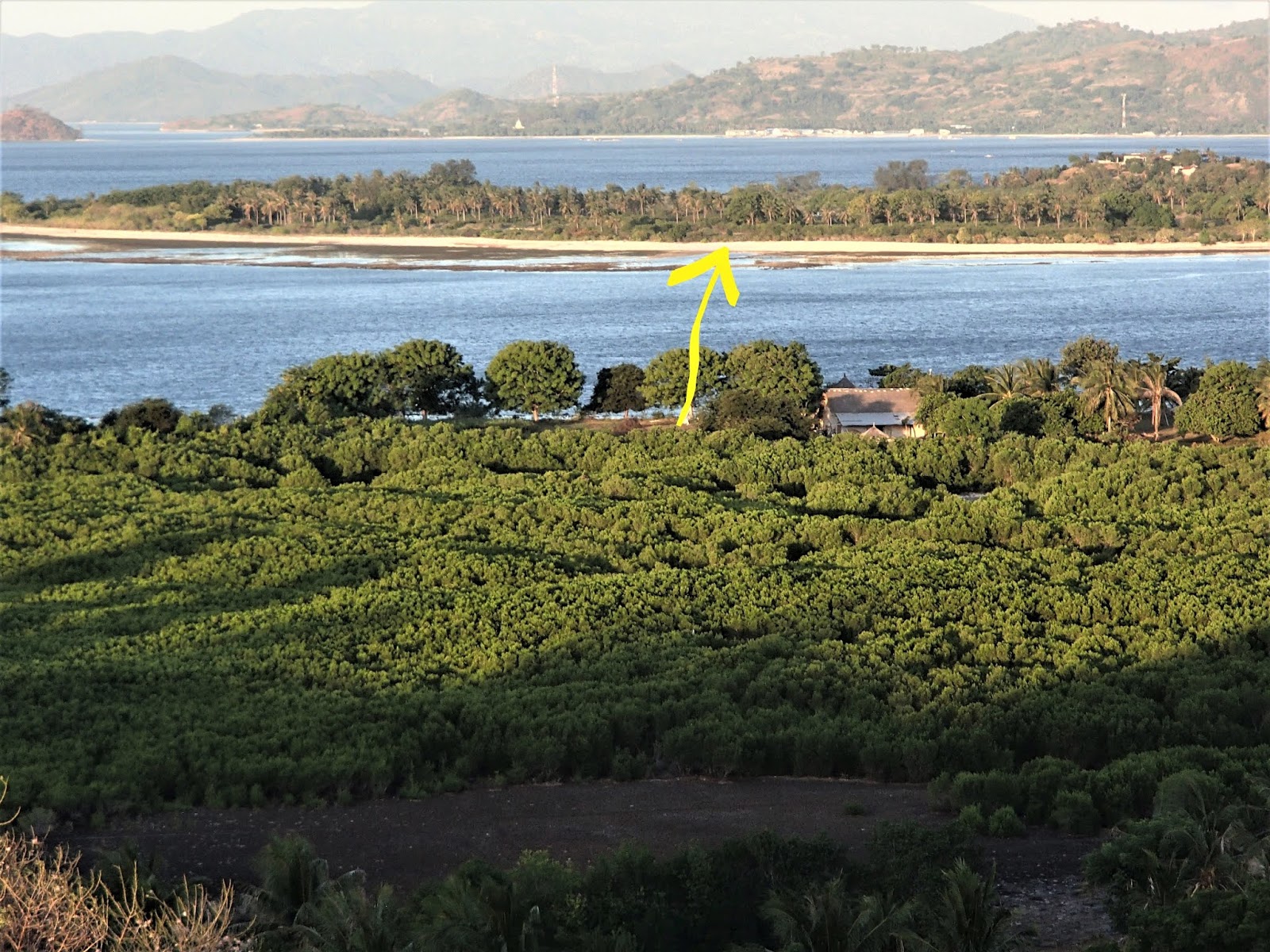
....THE WEST COAST OF NORTHERN GEDE....
....with of course the mainland in background. This shot gives a good idea of the vegetation covering that former LAYAR swamp (foreground).
VIEW NORTH
Composite shot may be clearer if you can click-expand image. GILI RENGIT is offshore and the north coast's low tide reef lagoon can be seen closer left. Image too small to spot TRAWANGAN's hill but it could just be seen way north.
VIEW WEST
 GILI ASSAHAN offshore with BALI's AGUNG volcano right background.
LATER VIEW WEST
The usual cloud interfering with a perfect sunset - I could see that without cloud it would be setting over BALI, but SOUTH of UBUD (in late JUNE - would be even further south [left] between then and late DECEMBER)
TRANSFERS
A demerit for the place is EXPENSIVE TRANSFERS. This is the resort boat bringing me from GEDE's pier: 3.6km at IDR150K each way! Seems the local boaties have a cartel operating -no matter who I asked it was still 150k.
Problem is as a single traveler I had no one to split the fare with - and I'm a single BUDGET traveler AKA "CHEAPSKATE".
Not sure how much for for the greater distance from the mainland to LAYAR - forgot to ask at the resort. So shoot me.
TIP - if you have non-waterproof luggage pack your stuff inside in a big plastic bin liner or similar: the trip can get wet and rough. Coming back was a bit bumpy/sprayey in sections.
GETTING TO GEDE
FROM BALI - in the past this has been a protracted project: least expensive was and still is a PERAMA shuttle to PADANGBAI on BALI's mid east coast, then the slow vehicle ferry to LEMBAR in south-west mainland LOMBOK, from where you can get a series of local bemos to one of the mainland fishing towns adjacent GEDE for a local boat across to the island. I reckon I could do this for about ID100K one way but it would take all day - with an early start.
Slightly easier/quicker - TAMARIND resort has a pick-up service in LEMBAR for 250k. I'm sure other resorts have similar.
I guess you could also catch one of the fast boats to mainland north-west LOMBOK via GILI TRAWANGAN - but getting from there to the fishing boat to GEDE would be a real hassle. Trust me - I've traveled many times in LOMBOK on local transport.
THE GOOD NEWS is that GILI GETAWAY FAST BOAT have recently started to run one of their craft from SERANGAN harbour near KUTA BALI to their pier on GEDE's mid east coast, via NUSAS LEMBONGAN and PENIDA. This includes pick up/drop off from/to properties in the near KUTA area (more distant places are surprisingly low in price).
THE BAD NEWS is that this is fairly expensive - IDR1.3 million: $aud130!! I have done many fast boat trips in THAILAND and MALAYSIA at much more reasonable rates - most also had pick up/drop off: sometimes both ends.
Check with your GEDE accommodation - they may be able to get you a discount.
In all fairness GGFB's rates to LEMBONGAN and PENIDA are much more reasonable.
Pick up for the second 11am boat gave me plenty of time for breakfast at my KUTA digs.
SERANGAN is way closer than SANUR from where most of the fast boats leave (to LEMBONGAN and PENIDA - none go to GEDE yet).
The SERANGAN terminal is much closer to KUTA than SANUR. Some even start in PADANGBAI (which is not bad if you are staying in east/north BALI and the UBUD region - not recommended from the KUTA area)
Above is the SARANGAN reception area - shared by a number of companies. Has refreshments, bathrooms etc. There is a busy market area outside.
This is much better than at SANUR where you have to walk much further from your vehicle and can be jammed into 20 odd cramped waiting areas.
SERANGAN boats leave from the adjacent pier which is way better than off the beach at SANUR.
Note that unlike a lot of fast boats this has an undercover compartment for luggage so you don't have to waterproof your main bags.
First call in is at LEMBONGAN (30 min) - here is one of the day-tip platforms for bigger fast boats from BALI. I'm always fascinated with new LEMBONGAN development - I visit most years and there is always a bunch of new places on the hills and in the bays.
I sat up top on the outward trip - got pretty wind and sun-blasted. Was a little rough some sections but I have seen much worse in areas of the trip I've done before.
Here we are nosing into NUSA PENIDA's north coast fast boat pier at BUYUK (60 min). This is more east than central on this unexpectedly attractive tropical coast - nevertheless maybe 70% of PENIDA's abundant tourist accommodation is within 5km.
Arrival at GEDE's east coast ORONG BUKAI pier about 1.75 hrs after leaving SERANGAN. Lotsa small boats from various resorts waiting to take passengers further, but I was staying 100m walk from the pier.
On the return trip I got out of the wind and sun down in the main cabin. Noisy but reasonably comfy.
SUM UP - a time-saving and interesting trip which conflicted with my cheapskate nature. Maybe next time I'll catch the slow boat. Or simply hop off in LEMBONGAN and/or PENIDA. Great places.
I have a TRIPADVISOR review of GGFB to GEDE HERE.
FROM THE NORTH WEST GILIS - TRAWANGAN-AIR-MENO
GILI GETAWAY's runs from the NORH WEST GILIS to GEDE in LOW SEASON ONLY. I think it goes via some MAINLAND LOMBOK locations.
Otherwise you will have to get yourself across to that hell-hole BANGSAL (scam capital of LOMBOK) on the mainland from where a series of bemos will eventually get you opposite GEDE for a fishing boat ride. I would not like to do this trip.
FROM KUTA LOMBOK and elsewhere - local transport can get you to opposite GEDE: note THAMARIND resort quotes some attractive fares from a number of locations including KUTA and the AIRPORT - I'm sure some of the other resorts can do similar.
-------------------------------------------
ATTENTION -IF YOU HAVE ADDITIONAL INFO OR SEE MISTAKES PLEASE MENTION IN THE AREA BELOW. BUT IF YOU HAVE QUESTIONS PLEASE ASK IN THE FORUM WHICH I CHECK FAIRLY FREQUENTLY WHEREAS I REVISIT THESE INDIVIDUAL DESTINATION PAGES ONLY RARELY.


No comments:
Post a Comment