NOUMEA BEACHES - NEW CALEDONIA
Last visited JAN 2019
This page is becoming a bit lengthy - people seeking stuff on a PARTICULAR BEACH will find:
ANSE VATA BCH - 5% down page
LEMON BAY - 20
DUCK ISLAND - 30
CHATEAU ROYAL BCH - 65
PLAGE DU MERIDIAN - 70
KUENDO BCH - 75
PLAGE DES NUDISTES - 80
CHS BCH - 85
AMADEE LIGHTOUSE - 90
NOUMEA is the capital of NEW CALEDONIA and paints itself among other things as a beach destination.
But I'm not whelmed. What we have here, at least for the places I've seem, are way ordinary strips of sand. I'm thinking for NOUMEAN good beaches you need to head OFFSHORE.
Although no doubt the rest of GRANDE TERRE, the big main island of NOUMEA, has some drop dead gorgeous beaches - but I haven't managed to get to them. The only land trip out of NOUMEA I've done is back in the 70's into the mountains, not the coast.
I know the LOYALTY ISLANDS north of GRANDE TERRE and the ISLE OF PINES to the east-south-east, can do the job. Some of their beaches feature on other pages of this blog - see the INDEX.
GRANDE TERRE, THE LOYALTIES and ISLE OF PINES
 GRAND TERRE relative to LIFOU and MARE (LOYALTY ISLANDS) and ISLE OF PINES.
Go to the INDEX - click on YEJELE BEACH (MARE), ISLE OF PINES and LIFOU.
 This page's beaches relative to CBD and CONTAINER TERMINAL (where big cruise liners dock). The CRUISE TERMINAL where small and intermediate liners tie up is just left of the CBD PLACE MARKER.
For a linear scale it is 5km/3.1mi between top and bottom place markers.
ANSE VATA - last visited JAN 2019
This is probably the city's #1 beach. But I found 2 deficiencies:
- EXPOSED TO THE SOUTH EAST TRADE WINDS (particularly the western half) which seem to blow more often than not in these latitudes.
These can be welcome in the hottest 3 months of the year but can become quite unpleasant in cooler months despite NOUMEA being within the tropics (just).
- TOO THIN: I found in recent years that there is a deficiency of sand from water to back of beach - in Feb 2018/Jan 209 mid and eastern areas areas had only 2m mid-tide and NO BEACH full tide. Bit wider towards the western end - a little over 3m full tide. SANTA MONICA it ain't.
Note my first 2 visits in the mid 70s saw plenty of sand - maybe TROPICAL CYCLONES (HURRICANES/TYPHOONS to you northern hemisphere dudes) have cut a lot of sand.
Last visited JAN 2019
This page is becoming a bit lengthy - people seeking stuff on a PARTICULAR BEACH will find:
ANSE VATA BCH - 5% down page
LEMON BAY - 20
DUCK ISLAND - 30
CHATEAU ROYAL BCH - 65
PLAGE DU MERIDIAN - 70
KUENDO BCH - 75
PLAGE DES NUDISTES - 80
CHS BCH - 85
AMADEE LIGHTOUSE - 90
NOUMEA is the capital of NEW CALEDONIA and paints itself among other things as a beach destination.
But I'm not whelmed. What we have here, at least for the places I've seem, are way ordinary strips of sand. I'm thinking for NOUMEAN good beaches you need to head OFFSHORE.
Although no doubt the rest of GRANDE TERRE, the big main island of NOUMEA, has some drop dead gorgeous beaches - but I haven't managed to get to them. The only land trip out of NOUMEA I've done is back in the 70's into the mountains, not the coast.
I know the LOYALTY ISLANDS north of GRANDE TERRE and the ISLE OF PINES to the east-south-east, can do the job. Some of their beaches feature on other pages of this blog - see the INDEX.
GRANDE TERRE, THE LOYALTIES and ISLE OF PINES

Go to the INDEX - click on YEJELE BEACH (MARE), ISLE OF PINES and LIFOU.

For a linear scale it is 5km/3.1mi between top and bottom place markers.
ANSE VATA - last visited JAN 2019
This is probably the city's #1 beach. But I found 2 deficiencies:
- EXPOSED TO THE SOUTH EAST TRADE WINDS (particularly the western half) which seem to blow more often than not in these latitudes.
These can be welcome in the hottest 3 months of the year but can become quite unpleasant in cooler months despite NOUMEA being within the tropics (just).
- TOO THIN: I found in recent years that there is a deficiency of sand from water to back of beach - in Feb 2018/Jan 209 mid and eastern areas areas had only 2m mid-tide and NO BEACH full tide. Bit wider towards the western end - a little over 3m full tide. SANTA MONICA it ain't.
Note my first 2 visits in the mid 70s saw plenty of sand - maybe TROPICAL CYCLONES (HURRICANES/TYPHOONS to you northern hemisphere dudes) have cut a lot of sand.


Not so impressive this 2015 low tide shot from eastern end (note wet sand to back of beach).


Several places along the beach concourse rent equipment and give lessons.
That's the rather good DUCK ISLAND in background (see down page) - 5 minute frequent water taxi from mid ANSE VATA for a better beach and some okay snorkelling. Island entryFREE - water taxi less than $20aud return.

SUM UP - compared to the thousand-odd other beaches I've visited I have to rate this one BELOW AVERAGE. Not bad Mind you but nothing to get excited about. Unless you are a WIND SURFER or KITE BOARDER.
ANSE VATA and SURROUNDING AREA

You can see the relative closeness of DUCK ISLAND and QUEEN TORO VIEWPOINT top of eponymous big hill - the later is well worth the walk from ANSE VATA (note city bus #10 goes up and several tourist buses and the Chou Chou train from the CRUISE TERMINAL or DOCK also visit).
For LINEAR SCALE it's 1200m between place markers of DUCK ISL and WATER TAXIS.
COSE-UP OF EASTERN HALF OF ANSE VATA

Note this half of the beach is more protected from the SE TRADES - the best windsurfing/kite-sailing is off the western half.
GETTING THERE
ANSE VATA coupled with the adjacent BAIE DES CITRONS and CASINO areas comprises NOUMEA'S main tourist hotel zone, so access is a relatively short walk for people staying there.
However a majority of visitors these days is made up of CRUISE SHIPS PASSENGERS (over 20 liners visit each month) - access is probably easiest hopping on the ship-booked JUMP ON/JUMP OFF BUS at the CRUISE TERMINAL. But at half the price other JO/JO buses run out of the CRUISE TERMINAL (free frequent 10 minute shuttle from the CONTAINER PORT where most big liners dock) - these are the go. LYVAI TOUR (look for the dudes in the red t-shirts) tends to have more and more frequent buses. I think they are least expensive these days too.
TOWN BUS 12 which I think is called the beach bus also runs from the CRUISE TERMINAL ARE , + town buses 10, 11 AND 70 depart from stops a few blocks inland from the TERMINAL near COCONUT SQUARE. However you will need CPF FRANCS for town buses. LYVAI etc take Aussie dollars and credit cards.
The popular CHOU CHOU TRAINS run past ANSE VATA and BAIE DE CITRONS but don't stop. Once again LYVAI'S CHOU CHOU is abt half the price of the one starting at the ship.

Note VOYAGER OF THE SEAS at the container port in background - a bit further than this shot suggests: I have cranked a bit of telephoto into the ol' elcheapo OLYMPUS.
-----------------------------------------
BAIE DES CITRONS (LEMON BAY) - last visited Feb 2018
Okay - technically the beach here is called PLAGE DE LA BAIE DES CITRONS, but I like it simple, say LEMON BEACH.
I prefer this one to neighbouring to the east ANSE VATA, mainly because it's SHELTERED FROM THE PREVAILING SE TRADES and HAS MORE SAND AT FULL TIDE.


Note lack of chop and the smallest of wavelets - this is a good beach for kids, and adults who are a bit phased by rougher stuff. The fact that the water shelves fairly gently doesn't hurt either.
However WIND SURFERS and KITE BOARDERS will not be impressed by the sheltered conditions.
Note too there is NO SHORTAGE OF SHADE behind the beach. Also some outdoor showers and rest rooms.

SUM UP - you won't be writing home to mum about this one either but to me it is a step up from its neighbour - to SATISFACTORY.

GETTING THERE - same as up page for ANSE VATA.
-----------------------------------------
DUCK ISLAND (ILE aux CANARDS) - visited Feb 2018
MOST CORAL CAYS TAKE SOME REACHING - THIS ONE IS LESS THAN 10 MINS FROM NOUMEA CITY (ACTUALLY CENTRAL ANSE VATA BEACH) VIA FREQUENT WATER TAXI.
But I was left a little perplexed - plenty of gulls BUT WHERE'S THE DUCKS?
DUCK ISLAND AND NEARBY NOUMEA LOCATIONS.

DUCK ISLAND from QUEEN TORO VIEWPOINT.

Note you can see the outer BARRIER REEF (white streak) from here - some 20lkm from the camera. No surprises - NOUMEA'S big island (GRAND TERRE) has the second biggest barrier reef and enclosed lagoon in the world.

Note the size of the surrounding reef in the above GOOGLE EARTH pic. Somewhat surprisingly I found BEST SNORKELING was in the WHITE ARROW area. Boats arrive in the YELLOW area - and the BEST BRACH is behind both WHITE and YELLOW. For those seeking a more secluded section of beach, CHARCOAL does the trick. I forgot to mark the SEA BIRD HATCHERY AREA - it's just north of the SOUTH EAST CORNER near the 200m place marker.
THE BEACH
Another plus is this is on the LEE SIDE of the island and thus protected from the prevailing SE TRADE WINDS which I find a pain. On a moderately blustery day it was pretty benign here.
Above we have lotsa room to lay a towel/sarong on the sand at front - behind is the day-resort SUNLOUNGE area: can be rented at what I thought an excessively high fee (but I'm a cheapskate).
Sand was white/yellow. Lotsa coral debris particularly near the water which made my elcheapo chain store REEF BOOTIES a good investment.
SUN LOUNGE AREA

DAY TRIP BAR


There is also a REST ROOM area nearby. No accommodation on DUCK ISLAND.
SNORKELING

Further out the coral lost colour and size. I didn't continue to the REEF DROP-OFF (white buoys) because I was feeling lazy - but cut me a break: at almost 73 I've lost a bit of enthusiasm for long swims to places might be (but very seldom are) a step up. However a DIVE BOAT tied up out there indicated it could be an interesting spot.
Day trip resort can rent snorkel gear but it ain't a bargain - my Brit mate from the water taxi demurred so I lent him my mask. I always carry a face mask - can do without bulky fins and snorkel..
ALTERNATIVE SNORKELING

ALSO - I did check the area to the RIGHT of the boat arrival spot - a lady told me she saw some TURTLES there. Nada for me - the area featured plenty of sea grass, little coral, some fish - turtles had shot thu.
STROPPY SEA BIRDS

East coast pretty barren - cops the SE TRADES full on. I'm thinking abt that SAND SPIT you can see far background - must have been from times time when the prevailing winds REVERSE for a short time, the resulting currents dragging sand off the BEST BEACH area. Or maybe there is a permanent tidal current on the waxing or waning tide despite the prevailing south-easterlies - I didn't notice any side drag when snorkelling to the left of this area.

Once back, I headed left to check out WESTERN ANSE VATA and LEMON BEACH, but you can easily head right for EASTERN ANSE VATA and the PAVEMENT CAFES across the road, the CHATEAU ROYAL beach area and the superior QUEEN TORO VIEWPOINT behind. You can save a bit (not much) of walking by crossing the road to the JUMP ON/JUMP off bus stop and going a minute or two to the NORTH ANSE VATA TURN-AROUND which is very near the SIDEWALK CAFE precinct.
-----------------------------------------------------
CHATEAU ROYAL BEACH - last visited JAN 2019
This one is really a extension of ANSE VATA but its orientation makes it more sheltered from the south east trades.

CHATEAU ROYAL WIDE BCH

CHATEAU ROYAL BCH NARROW

Interestingly this narrow section is actually in front of the MERIDIEN HOTEL but this is not PLAGE DU MERIDIAN - that beach is immediately south (see down page).

I grabbed my FACE MASK and checked the scene out there - probably only 2m deep 250m from the sand. A lot of sea grass, a few scattered small coral bommies with fish - novice snorkelers may find it interesting but hard core types will be bored.
-------------------------------------------------------------
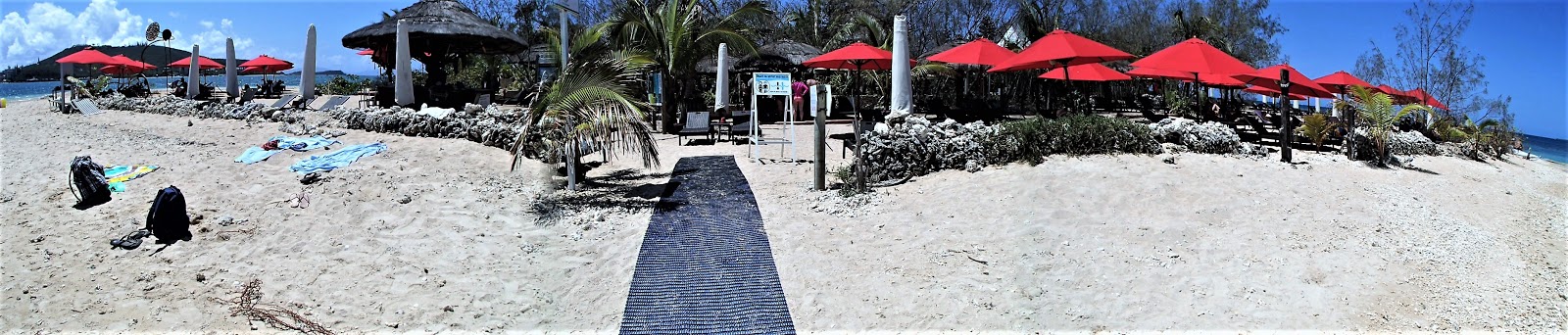
PLAGE DU MERIDIAN (MERIDIEN BCH)

Not sure about status re public access - offshore is a designated wind/kite surfing area, but there is a wire fence going inland from that breakwater at top which I found easy to walk around. Only half a dozen beach goers on a nice day when CHATEAU ROYAL BEACH had well over a hundred.
-----------------------------------------------------------------------
BEACHES OF THE NOUVILLE PENINSULA
last visited Nov 2018

KUENDO BEACH

The 400m long beach itself is spit into 2 parts - the southern public section and the northern resort section. Labels will be clearer if you click-expand image.


I'm not real sure how many resorts are on the northern half - the internet talks of KUENDO BEACH RESORT and KUENDO BEACH HOTEL but is never clear on if this is one place with 2 names, or 2 places.
Note how smooth the bay is - I think you may need a TROPICAL CYCLONE SWELL to generate any waves or even wavelets here. This, the shallow water and the park make for an excellent kids' beach.
PLAGE DES NUDISTES

This is about 300m south of KUENDO on the east facing coast, across a slightly raised cleared section of land inland of the steep western headland of KUENDO - see image below. Shorter than KUENDO but otherwise much the same EXCEPT it faces east into the south easterlies and is not backed by parkland. Note no nudists the nice weekday of my visit.

NO NAME BEACH

Then again - the GOOGLE nominated PLAGE DES NUDISTES does have decent parking just behind the beach - something NOUMEA's weekend naturists might appreciate.
CHS BEACH

I shot this from a storm-water pipeline showing abt 400m of beach. Behind camera is another 200m odd, backed by housing in the furthest end.
Summing up, I wouldn't write home to mum about this beach.

-----------------------------------------------------------------
COMING UP
With more NOUMEA visits in 2019 (Lady Tezza sure is a keen cruiser and I can't say no to 8-11 days of relaxation/eating on a huge liner - and all liners calling in at the smaller NOUMEAN islands must also visit NOUMEA insist local authorities) I am not sure which beach to visit. The only one I haven't checked since the 1970s is that at AMADEE LIGHTHOUSE. The island here is bigger than DUCK ISLAND and the beach goes right around. There is also a surrounding lagoon which offers snorkelling and from my 70s memory, water skiing. My memory is a bit vague after all this time but I seem to remember a nicer beach than at DUCK ISLAND which I regard as NOUMEA MAINLAND'S best.
But the question is - is AMADEE LIGHTHOUSE a NOUMEA beach? It's 25km due south from the Marina guarding a pass in the BARRIER REEF. At 25km, I don't think so.
The other thing is the trip out there is not too easy much of the time. When the SOUTH EAST TRADES BLOW a lot of the way can be choppy and uncomfortable. And not inexpensive.
So don't hold your breath for any upcoming report.

----------------------------------------------------------------
IF YOU SEE MISTAKES OR HAVE ADDITIONAL INFORMATION, PLEASE POST BELOW.
BUT IF YOU HAVE QUESTIONS PLEASE ASK THEM IN THE FORUM SECTION WHICH I CHECK MOST DAYS WHEN NOT TRAVELLING - WHEREAS I SELDOM REVISIT THESE INDIVIDUAL DESTINATION PAGES.


