
ATTENTION - THIS PAGE HAS TURNED OUT MUCH LONGER THAN EXPECTED.
FOR PEOPLE WHO HAVE BEEN DIRECTED HERE BY SEARCH ENGINES, THE FOLLOWING MAY SAVE A BIT OF TIME:
KIAMA COASTAL WALKING PATH - 60% DOWN PAGE
KIAMA POINT-HARBOUR-LIGHTHOUSE AND BLOWHOLE AREA -35%
LITTTLE BLOWHOLE 67%
SURF BEACH - 5%
KENDALLS BEACH - 7%
BOMBO BEACH - 10%
EASTS BEACH - 14%
BLACK BEACH - 16%
JONES BEACH - 30%
MINNAMURRA BEACH - 32%
WERRI BEACH - 78%
GEROA BEACH/7 MILE BEACH - 79%
MAIN ST - 22%
MINERS' COTTAGES - 25%
THE FLAT - 18%
KIAMA CONTINENTAL POOL - 20%
KIAMA ROCK POOL - 40%
KIAMA SHOWGROUND - 48%
KIAMA MARKETS - 80%
KIMA LEISURE CENTRE - 92%
GERRINGONG - 75%
GEROA - 80%
JAMBEROO - 83%
KIAMA HINTERLAND - 82%
CYCLING - 90%
ACCOMMODATION - 91%
WHALE WATCHING - 95%
ACCESSING KIAMA - 97%
There are many good day trip destinations out of Sydney. KIAMA is one. It has great beaches, a beaut little harbour, a popular coastal walk, no shortage of eats/drinks joints, a full range of accommodation, scenic viewpoints, a nice hinterland yada. And we haven't mentioned its most famous attraction - THE BLOWHOLE (actually, there are 2). It seems a favourite with Asian and Middle East visitors - maybe because they get less hassle here.
Day-trip wise it has the advantage of being just under 2 hour's drive from central Sydney (just when many drivers are figuring it's time to take a break), and a scenic 2.5 hour train trip.
This is a hilly town, meaning seaside places aren't the only ones with great views.

BEACHES
KIAMA has 4 good beaches within walking distance of the main street and another 2 a short drive further north.
4 CLOSE BEACHES

SURF BEACH
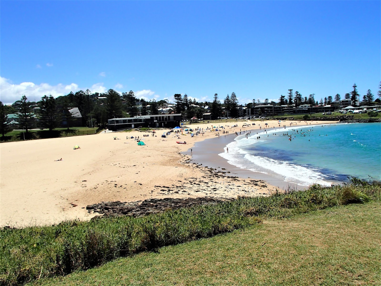
The building mid shot is the surf lifesaving club. This is backed by a nice park area (CORONATION PARK) which is a big destination for visiting picknickers and others particularly weekends. So too is the grassed area in foreground. Behind it is a council run holiday village with some very neat cabins with killer ocean/beach views. Note too the tents and caravans far right background. This is the showground #2 playing field which the council opens to visitors Christmas and Easter.
This beach faces SE, so picks up southerly/south-east swells (which tend to be the biggest swells on this coast) so it is not a bad surfing beach. At the same time the big showground-blowhole headland extending out of shot to the right protects it from north-east winds which are the most common here. So it is not bad north-east wind beach protection-wise.

KIAMA SURF BEACH has lifeguards 7/365.
KENDALL'S BEACH

Pastel purple arrow points at the council run holiday cabins behind SURF BEACH mentioned up page. Indigo arrow for similar cabins behind KENDALLS BEACH. There are also spaces for about 25 tents and caravans here. Orange points at more tents and caravans allowed by council at XMAS and EASTER on a big sports field between the beaches.


The far end of the beach is a real sun trap in winds from the southerly quadrant - the place to head for on those colder days when the sun is strong. Even in winter.
This beach has lifeguards XMAS and EASTER.
FISHING AT KENDALLS
Beach fishing is popular with visitors. But over many years I have never seen one catch a decent fish. I used to swim the length of the beach frequently - saw few fish (once saw a big ray and once swam into a huge Portuguese Man of War stinger). The rocks near beach far end above are also popular and if you want to catch some of those bony, foul tasting muddy rock cods this is the place. However some local kids who are very good snorkellers spear some excellent fish near a bombora (treacherous shallow reef) off the end of the point - at least 300m from the beach. The end of the point is also popular with rock fishermen, and they are not wasting their time.
SURFING AT KENDALLS
The protected nature of this beach means surfable waves of any size are not all that common. Great for families. However BODYBOARDERS work over a fun-kamikazi break at the north end when the southerly swell gets to a reasonable size and when it gets huge there is a rubbishy board/bodyboard break half way along the far rocks - the kind of wave surfers ride because it is rarely there, not because it is good.
BOMBO BEACH

The council provides a life guard at the north (far) end in the XMAS holidays. Not sure abt EASTER. There is also a parking area and change sheds at the north end.

A big wave surfing spot, the BONEYARD, is abt 3 mins walk north, and one of KIAMA town's less easily accessible beaches, KIAMA DOWNS BCH/JONES BEACH, another 10 minutes.
BOMBO RAIL STATION (abt mid-beach), the penultimate stop before KIAMA, must be one of the closest to the sand in Oz.

EASTS BEACH

Although a private operation, I notice the council has set up a lifeguard operation at XMAS and EASTER the past few years.

The length of each headland shows why this beach is so well protected from swell and wind.
A 5TH CLOSE TO TOWN BEACH - BLACK BEACH


The MAIN STREET is close behind the nearer half of this bay.
It is possible to walk the rock platform near YELLOW ARROW around to BOMBO BEACH in the lower half of the tide if they swell is not huge.
YELLOW X shows the position of a surf break which only works in huge swells - another rubbishy wave only ridden because it is rarely there.
FISHING WISE - the only place I regularly see fishermen is around the YELLOW ARROW area. Ditto SNORKELLERS.
THE BLACK BEACH AND BLOWHOLE POINT AREAS

My inadequate cropping tool couldn't exclude BLOWHOLE POINT so THE HARBOUR, LIGHTHOUSE and STORM BAY also feature well. For scale, it's 500m between the place-markers for 1 and STORM BAY.
NORTH of course is straight up.
----------------------------------------------------
THE FLAT.
This is an ex-playing field which stretches between the OLD PRIMARY SCHOOL (now THE SEBEL KIAMA HARBOURSIDE - an upscale hotel/resort) and the CONTINENTAL POOL. These days it attracts joggers, picknickers and casual sports like a scratch game of footy/cricket. It is also the site of several MARKETS a month (see down page), a fun fair around XMAS and several car show and shines each year.

I modified this shot from one I pinched off DESTINATION KIAMA.


The XMAS fun fair begins to arrive

CONTINENTAL POOL


That parking area to left is not directly accessible - has a steep 10m rise between.
There are new change sheds along the lower path at left maybe 60m from the pool. Showers closer.
----------------------------------------------
MAIN STREET
KIAMA has abt 7000 permanent residents** + at least that many day-trippers each week. So the main street features what you would expect from a town of 7000 PLUS a lot of tourist-oriented joints. There is no shortage of food outlets (everything from fast food to fancy restaurants), boutiques and accommodation booking places. There is the obligatory pub and a leagues club.
**not sure "permanent" is the best term seeing that some streets have about 25% of the houses occupied by rich dudes from the Big Smoke, mainly on weekends.

Blocks 2 (B2) and 3 (B3) are the busiest although there are other clusters of businesses (5 and C[Miners Cottages]) plus a medium size WOOLWORTHS SUPERMARKET [and soon an ALDI] plus some mall-type stores (6) about 250m west of the main COLLINS ST roundabout.
Other map features: Akuna St carparks (7), Rail Station (8). The popular park area across TERRALONG ST from B3 businesses is HINDMARSH PARK. BLACK BEACH and BAY show nicely around the NORTH indicator. THE FLAT can be seen to their north - although the CONTINENTAL POOL at its north end (just right of the Y of SYDNEY) is not real clear.
KIAMA HARBOUR far right certainly is, STORM BAY far bottom right less so.
MISTAKES - the "to Nowra" ARROW should be on parallel MANNING ST below the #5 place marker....
...the "to Jambaroo" arrow top left gives the impression the road curves. Not so, it is a straight shot past the BYPASS except for a roundabout just out of frame which leads to the QUARRY LEISURE CENTER (see down page). Once out of town, this road becomes JAMBAROO RD and is indeed very twisty. And hilly. Oh yeah, JAMBAROO is spelled wrong - it is JAMBEROO.
....and I forgot to put in a distance scale - it is 500m in a straight line between the place markers for "from Sydney" and "to Nowra"

BLOCK 3 which takes up half that stretch is where most MAIN ST stuff can be found


PARKING - vacant curbside spots are limited on weekends. There is a free lot behind south side shops of block 3, accessed off AKUNA ST - this tends to fill too but there is a little known lot across the road which usually has plenty spaces.
Bus access is weird - there are no public bus stops in blocks 1, 2 or 3. You need to go up near WOOLWORTHS. But bus transport in and to KIAMA is not a big deal.
THE RAILWAY STATION is very convenient - only 200m south of the start of block 2 (and another 30m to BLACK BEACH).
-------------------------------------------------------------
MINERS' COTTAGES

If you are doing the COAST WALK and have come over the top of PHEASANTS POINT from BOMBO BCH, best turn left immediately behind camera to reach THE FLAT/BLACK BEACH. But you can also walk down past these shops, turn left into MAIN ST and access BLACK BEACH and the continuation of the COASTAL WALKING TRACK anywhere along it.


-------------------------------------------------------
OTHER KIAMA BEACHES, TOO FAR TO WALK FROM MAIN ST.
JONES BEACH AND MINNAMURRA BEACH

JONES BEACH KIAMA DOWNS
KIAMA DOWNS is a suburb of KIAMA but this beach is a bit far to walk from town. By car it is 5km/3mi.
I've never had much to do with this beach, so can't tell you about surfing, fishing or swimming. But it faces east and would pick up swell (the near corner would be most sheltered from the prevailing north-easterlies) and has an active surf-lifesaving club and a board-riders' club.


This is more a locals' beach - gets few tourists so is a good one for lack of crowds.
MINNAMURRA BEACH
This is a short distance further north - JONES BEACH can be seen from the top of the big headland the camera is on.

MINNAMURRA BEACH at right is difficult to access - you need to swim/boat the river. Thus it is virtually deserted. The far end is a popular surfing spot called MYSTICS which picks up big southerly swell and is sheltered from the prevailing north-easterlies.
A small island called STACK ISLAND is offshore from the river mouth just out of frame right.
Popular KIAMA GOLF CLUB is just out of image to the left.
------------------------------------------------------------
KIAMA HARBOUR - BLOWHOLE POINT AREA


WHITE ARROW indicates the popular BLOWHOLE POINT ROCK POOL (see down page). CHARCOAL is at the approx position of THE BLOWHOLE which s slightly the other side of the headland. The nearby LIGHTHOUSE is lurking behind those trees to its right. The council run KIAMA HARBOUR CABINS line the sea-facing area below. ORANGE shows harbourside CARGO FISH AND CHIPS - the HARBOUR itself is to its left.

CARGO FISH AND CHIPS

Gets better - the local PELICANS often engage in the begging stakes. And some are BIG dudes.
You can get better value greasies up MAIN ST, but those joints don't have this outlook + the avian entertainment.
MOVING EAST ALONG THE HARBOUR

The COASTAL WALK goes right along the harbourside.

Abt 25% of those boats are CHARTER FISHING BOATS - these pick up customers particularly on weekends for a few hours of offshore drinking, telling lies and ..... occasionally fishing. Sounds like a fun time to me.


FISHING AT KIAMA HARBOUR
I see a lot of people dipping a line here. But I have never seen anyone haul a fish in. So I can't really say if this is a gun place to wet a line.


In big seas, waves break into the ROCK POOL, making things a bit exciting. In the same conditions the wave you can see mid-left becomes surfable - but once again it is fairly rubbishy, only ridden because it is rarely there.


You are not far from KIAMA LIGHTHOUSE here. The (BIG) BLOWHOLE is just out of frame to its left.
The COASTAL WALKING TRACK goes by here.

KIAMA HARBOUR CABINS overlook the pool area, ocean, and along the road at right THE HARBOUR. I'm gonna stay here one day.
KIAMA LIGHTHOUSE

The lighthouse is not open to visitors.
THE (BIG) BLOWHOLE


Over the years, the bore has increased, meaning bigger swells required.


ROCK SAFETY
Dozens of rock-explorers and rock fishermen are swept to their DEATHS in Australia each year. Sadly KIAMA is not exempt. Some years back a dozen Asians were swept off those rocks above. Most couldn't swim. And there have been many other instances in different parts of the municipality.
Some tips:
- if rock fishing always wear the compulsory life jacket
- beware of ROGUE WAVES which come along every now and then and can be TWICE the size of the average swell. This is what got the Asians.
- if swept into the water don't try to climb back onto the rocks - most deaths occur when people are smashed against the rocks, knocked cold and drown. Instead swim out away from the rocks. tread water (a minimal effort activity even the poorest swimmer can do for hours - if you can't swim at all you shouldn't have been on the rocks) and raise a hand in the air (the universal HELP signal). A surfer or competent nearby rough water swimmer will soon pick you up. KIAMA SLSC dudes and dudettes have been training for years to do this sort of thing and are itching for a chance to help. The club has a JET POWERED RESCUE BOAT, several OUTBOARD POWERED RUBBER DUCKIES and even more RESCUE BOARDS. Latest additions - several JET SKIS towing a RESCUE SLED. A RESCUE HELICOPTER is stationed at nearby ALBION PARK AIRFIELD and there are often NAVY 'COPTERS passing.
Even simpler, someone on the rocks may throw you one of the many FLOATATION DEVICES the council installed in tricky rock areas around the municipality after the Asian tragedy.
Don't freak about SHARKS when in the water - you have more chance of being struck by lightning than nibbled by a noah. I surfed for 40 years, often in the sharkiest places, and never had trouble.
HYPOTHERMIA shouldn't be a problem - even in KIAMA'S coldest winter water this will take several hours to kick in - you should be out and dry long before.

It is not a real good idea to ask if she needs a CPR practice-partner unless you are a sun-bronzed surfer-grommet (which I haven't been since the early 1960s) - these ladies are taught some very effective chop-sockie moves to disengage panicking swimmers who grab them during a rescue. Don't ask how I know this.


HARBOUR - BLOWHOLE POINT FEATURES MENTIONED ABOVE

B - BLOWHOLE
LIGHTHOUSE TO STORM BAY
The BLOWHOLE HEADLAND
- has quite a few activity zones.

My inadequate cropping tool shows BLACK BEACH BAY far left and the BLOWHOLE far bottom right. The HARBOUR AREA also comes out well.
MILK AND HONEY CAFE (now DIGGIES)

This place is less than 100m downhill to the west of the LIGHTHOUSE and is a very pleasant place to spend time.

KIAMA VISITORS' TOURIST INFORMATION OFFICE

PILOTS COTTAGE MUSEUM


PRESENT DAY

STORM BAY

I have seen a fair few SCUBA DIVERS here - I think a local scuba school uses this as home base.
Snorkelling is also popular, and kids....

----------------------------------------------
THE SHOWGROUND
This is immediately south of STORM BAY.

It's 360m in a straight line between the place markers for STORM BAY and SURF BEACH.
AFTER CROSSING SURF BEACH and KENDALLS BEACH to its south, you then come to....
....LITTLE BLOWHOLE BAY (or DOLPHIN COVE as one overlooking airbnb place calls it).

The COAST WALKING TRACK comes via the camera's headland - then moves out to BOANYO AVE. to go south (those rocks are impassable - there is a big gorge (close right) leading into FRYERS CAVE which goes in so far I have never had the courage to swim up there even in the calmest seas. Some say it goes thru to just short of KENDALLS).
The gorge is a favourite spot for ....

This bay gets a lot of rock fishermen - they seem to do okay particularly when Blackfish (Rock Drummer) are running (usually after a storm when waves are big, chopping up the plentiful weed near the rocks).
The bay is also good for snorkelling and scuba diving. Beside the usual fish/lobsters/crabs there are also ABALONE although they are a bit deep for snorkellers (strict bag limits for snorkellers -scuba divers are not allowed to get them. Licensed abalone divers use air lines from compressors in boats - stay down for ages and take hundreds - but they always leave enough to regenerate).
Abalone are delicious on the BBQ.
I used to put in a lobster pot each night - often got zero, sometimes over a dozen. When they were around (less often than not) I knew several good cracks where I could grab them when snorkelling.
-----------------------------------------------------
LITTLE BLOWHOLE
This proves to be more consistent than the big blowhole and works best in a north-east swell which the big one rarely responds to - so it is always worth checking out.

Waves move up a gutter in the rock platform (CHARCOAL ARROW) and explode up thru a vent in the rock (YELLOW) from the cave underneath. Best conditions are in the higher part of the tide when there is a good north-easterly swell working (although bigger swells from the south work too). Pretty benign here - I have seen it blowing higher than the houses behind.
THAT'S MORE LIKE IT

The swell came up after I wrote the above - this is more like a decent blow.
Audio has value - goes SWOOSH!! - kind of a cross between a jet and rocket engine.
Note the VERY WHITE area between camera and LITTLE BLOWHOLE is usually a nice big rock pool with lots of small crabs, octopi, and other rock pool dwellers. They are probably hanging on for grim death above, saying STREWTH!
One time a couple of school teachers decided to amuse their excursion class by placing over the vent one of those big metal ice cream containers the shops take delivery of bulk stuff from the factory. The blow sent it 25m in the air - kids diving every which way to dodge its landing.
Jeez - those fun school teachers!
Another time I lost a lobster pot after an overnight storm - thought it might be in the blowhole cave so waited 'til the swell diminished and swam in for a look. Zero visibility - the cave was filled with finely chopped up sea weed - was like swimming in a huge tea pot. Never found the pot.
When waves break in the cave, vibrations often spread around the surrounding neighbourhood. One resident had to uninstall a brass door knocker because it knocked in response to the vibrations.
The COASTAL WALING TRACK goes right by the LITTLE BLOWHOLE then heads east (left above) around MARSDEN HEAD to EASTS BEACH.
------------------------------------------------------------------
VIEWPOINTS
With so many headlands and hills KIAMA isn't lacking in good viewpoints. I personally think the view north across to BLOWHOLE POINT, the SHOWGROUND, SURF BEACH etc. from KALEULA HEADLAND immediately south of KENDALLS BEACH takes some beating. As does that from BLOWHOLE POINT both north and south. Not to mention the top of PHEASANT'S POINT north over BOMBO BCH or from the top of MINNAMURRA ST just west of the MINERS' COTTAGES to the east over the HARBOUR and BLOWHOLE POINT.
Fact is, KIAMA has so many headlands and high areas with good views that it's hard to pick a winner

View over BOMBO BEACH from the top of PACIFIC ST.
But for most people the area's undisputed top viewpoint is.....
....SADDLEBACK MOUNTAIN LOOKOUT

The road up here varies from moderate to steep - gets REAL steep the last 500m which we see above. I have come up here often on a bicycle, but the only time I have ridden all the way was early in my triathlon period when I was younger and real fit. But I had to zig-zag this last 500m.

ACCESS - best take SADDLEBBCK MOUNTAIN RD which leaves the main road south thru town (the OLD PRINCES HIGHWAY) at the high school. After 1500m it intersects with OLD SADDLEBACK RD - turn left and go another 4.7km to the lookout.
About 25% of this is steep, 5% very steep, 25% flat or even downhill, the rest moderate - I walked up here daily when training for my GRAND CANYON trek - carrying lotsa water and pushing a bicycle. Fanged back down on my pushy - tip: it ain't a good idea to reach the high school at warp speed when students are leaving for the day


The top has walkways to several viewpoint areas.


Note the lovely hilly countryside close to the camera. Classic dairy farming country although some farms are now hobby farms for retirees and rich dudes from THE BIG SMOKE.


LOWER VIEWPOINTS

----------------------------------------------------------
KIAMA COASTAL WALKING PATH
This has become very popular with local and particularly visitors since the council negotiated with southern landowners and improved the south end of the track about 10 years ago. Prior to that it did exist - I walked the southern section with a friend abt 20 years ago (and have used the northern and central sections for more than 40 years): had to ignore crossing private farm property, climbing seaside cliffs and charging thru a railway tunnel back then.
There are 3 parts to the track: THE NORTHERN MINNAMURRA TO KIAMA section; THE MID SECTION THRU TOWN; and THE SOUTHERN LOVES BAY TO WERRI BEACH section. Each takes about 2-3 hours - the whole 3 can be done in one day, but ordinary trekkers will find one section at time a good deal.
THE NORTHERN MINNAMURRA TO KIAMA SECTION.

If walking, you can start a few hundred meters downhill to the north at....


The MINAMURRRA HEADLAND WHALE VIEWING PLATFORM is just to right of camera.
CATHEDRAL ROCKS

THE BONEYARD

The big wave take off area is actually just out of image lower-left - although there is not enough swell on the day of this particular GOOGLE EARTH IMAGE for it to work.
The area is accessed by a path leading down from the COASTAL WALKING PATH alongside the rail line lower right. The path and line are a good 20m higher than the water.

Beach in background is BOMBO. Structure in abandoned bluestone quarry is the KIAMA SEWAGE WORKS. The coastal walking path shows well in this shot.
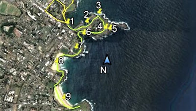
KIAMA COASTAL WALKING TRACK - MINAMURRA TO BOMBO SECTION

2/3 - TRAIL START (see below).
4 - MINAMURRA HEADLAND WHALE WATCHING PLATFORM
5 - JONES BEACH
6 - CATHEDRAL ROCKS
8 - THE BONEYARD
Straight line distance from 1 to 8 = 3000m
Symbols may be clearer if you can click-expand image.
GETTING TO THE START IF YOU HAVEN'T A CAR

2 - JAMES OATS RESERVE - abt 700m from station.
3 - CARSON PLACE - abt 850m from station.
There is a bus stop on the yellow route only 160m from JAMES OATS RESERVE. #71 runs hourly on weekdays, less often weekends.
Straight line distance from 1 to 3 = 600m
000
No shortage of route signs - this one at the north end of BOMBO BCH.

BOMBO BEACH. Once again walk along the sand. At the far end you can usually walk around the seaside rocks below the top half of the tide unless the swell is big. If so, take the road UP OVER the headland (YELLOW) which will dump you into KIAMA at the MINERS COTTAGES and close to BLACK BEACH.
FINISH OF NORTHERN SECTION - SOUTH BOMBO BCH TO BLACK BCH. KIAMA

2 - LOW TIDE LOW SWELL ROCKS ROUTE
3 - GIPPS/COLLINS STS. OVER PHEASANT POINT
4 - MINERS COTTAGES
5 - MAIN ST
6 - BLACK BEACH
It's 700m in a straight line from 1 to 6.
GETTING BACK TO THE START.
Train travellers from Sydney may not be bothered - they simply get off at at MINNAMURRA STATION and walk thru to KIAMA - there to continue the walk, explore the town or whatever.
Almost as easy for car people - leave vehicle near station, walk thru to KIAMA and then train back to MINNAMURRA. The alternative is the not-so-often bus - GOOGLE MAPS will tell you which bus to look out for.
0000000000000
THE MID SECTION THRU TOWN.
Take the path in back of BLACK BEACH, and if you didn't eat at MAIN ST or MINERS COTTAGES stop for a feed of greasies at CARGO FISH AND CHIPS. Place is more expensive than uptown but has great outlook - also beer/wine which is rare uptown.
Then walk along the harbourside to the ROCK POOL, go uphill to the BLOWHOLE. Then go down the headland to STORM BAY, around the SHOWGROUND PERIMETER to SURF BEACH and then over to and along KENDALL'S BEACH.
MID SECTION - STAGE 1 - BLACK BEACH TO KENDALLS BEACH
1 - BLACK BEACH
2 - KIAMA HARBOUR
3 - ROCK POOL
4 - KIAMA LIGHTHOUSE
5 - THE BIG BLOWHOLE
6 - STORM BAY
7 - KIAMA SHOWGROUND #1
8 - SURF BEACH
9 - KENDALLS BEACH
Linear scale - 1400m in a straight line from 3 to 9
From there (KENDALLA BCH) make your way to THE LITTLE BLOWHOLE (maybe a quick diversion to the nearby v popular LITTLE EARTH CAFE for a coffee/snack/ the wine bar/art gallery up there is also popular - often has live music).
MID SECTION - STAGE 1 - BLACK BEACH TO KENDALLS BEACH

1 - BLACK BEACH
2 - KIAMA HARBOUR
3 - ROCK POOL
4 - KIAMA LIGHTHOUSE
5 - THE BIG BLOWHOLE
6 - STORM BAY
7 - KIAMA SHOWGROUND #1
8 - SURF BEACH
9 - KENDALLS BEACH
Linear scale - 1400m in a straight line from 3 to 9
From there (KENDALLA BCH) make your way to THE LITTLE BLOWHOLE (maybe a quick diversion to the nearby v popular LITTLE EARTH CAFE for a coffee/snack/ the wine bar/art gallery up there is also popular - often has live music).

Then head around the headland to and across EASTS BEACH, and finally make your way around its southern headland to the beginning of the 3rd section of the track at LOVES BAY. You may find the final few hundred meters easier to do on the roads adjacent the reserve.
MID SECTION STAGE 2 - KENDALLS BEACH TO LOVES BAY

9 - KENDALLS BEACH
1 - BOANYO AVE
2 - LITTLE EARTH CAFE
4 - EASTS BEACH
5 - LOVES BAY
NORTH is straight up. LINEAR SCALE - 1900m in a straight line from 9 to 5. Click image to make numbers clearer.
GETTING BACK TO THE START
You could simply retrace your steps - but this is not the shortest route. That is to retrace your steps to the north end of EASTS BEACH and then take surface streets back to the MAIN ST area. GOOGLE MAPS is once again your friend.
People not wanting to walk will find the #126 leaves from a stop in KALANG RD only 200m from the LOVES BAY end of the central section. But that bus is not real frequent.
000000000000000000
THE SOUTHERN LOVES BAY TO WERRI SECTION


CAVEAT - the walk ends at WERRI BEACH and to access the beach and get to parking areas, bus stops (services are not very frequent) or to continue your walk to GERRINGONG STATION you need to cross the entrance to WERRI LAGOON. Normally this is no problem - 95% of the time the entrance is shut. 4% shallow because of minimal flow, but in rare times after heavy rain it is impassable. You have no real option but to retrace your steps north to LOVES BAY.
Open/shut status can be checked on 1300 654 262

....as was the case when the GOOGLE EARTH satellite snapped this in FEB 2016

2 - amenities block
3 - small parking lot (more curbside).
As can be seen above, there are rest rooms adjacent the small beach parking area at the end of the walk.
If you are hungry, a fish and chip shop is about 900m along the beach road.
There are bus stops adjacent the FISH AND CHIPS SHOP (not sure which side goes north, which side goes south) - the #126 north goes back to KIAMA STATION. But google the timetable - they are not frequent.
KIAMA COASTAL WALKING TRACK ROUTE - SOUTHERN SECTION

Total walking distance is 6km contrasting with a straight line distance between 1 and 2 at 3.7km
#1 is the start of the SOUTHERN WALK at LOVES BAY - #2 the finish at the amenities block NORTH WERRI BEACH.
GETTING BACK TO THE START
RE-WALING the 6 km route is one option. But that is pretty time consuming.
A better choice for 2 or more with a car is to drop one half of the trekkers at LOVES BAY, drive and park at the WERRI BEACH end, start trekking north - and swap keys when meeting the other half.
Alternatively you could walk one way and catch the train the other. BUT....
....GERRINGONG RAIL STATION is a hell of a distance from the end of the COASTAL TRACK - abt 3.6km. However most is a pleasant walk. Best trek along lengthy WERRI BEACH, turn inland and go up the hill to GERRINGONG MAIN ST, walk down it and turn right at BELINDA ST, off which you will find the station after 900m. A southward going 126 bus from the beach road adjacent the chips shop drops at a stop in BELINDA ST 500m from the station - this south-going 126 goes thru to GEROA BEACH further south which is the north end of 7 MILE BEACH and is a destination worth exploring in itself.
Alternatively you could catch a NORTHWARDS heading 126 and go right thru to KIAMA - either the main street/railway station area or (if you have left a vehicle at LOVES BAY) to a stop in KALANG RD abt 500m from your car. Ask the driver for the nearest stop to the start of the track.
GETTING TO GERRINGONG STATION

1 -chip shops, adjacent bus stops
3- Gerringong Whale Watching Platform
4 - Gerringong main street
5 - rail station
The straight line distance between 2 and 5 is 2.5km
-------------------------------------
GERRINGONG - this township has the usual retirees, holiday makers and younger people who mainly work in nearby PORT KEMBLA heavy industries, in WOLLONGONG businesses or are TRADIE FAMILIES (bricklayers, carpenters, sparkies and other trades-people who work in the busy building/extensions trade of the region). Others of course.


---------------------------------------------
WERRI BEACH
Even though WERRI and adjacent GERRINGONG are within KIAMA MUNICIPALITY, I don't regard the beach as a KIAMA BEACH because at 10km from KIAMA MAIN ST it ain't exactly close.

Council has spent big on a long narrow park like area between the beach and the backing PACIFIC AVE. I last visited on one of those magic, windless, sunny winter days - the whole town seemed to be out walking the paths, sitting on the grass or supervising kids on the many areas of play equipment.
Note there is a WHALE WATCHING PLATFORM higher up this headland behind camera.
---------------------------------------
GEROA BEACH.
This is the northern end of long 7 MILE BEACH. The village of GEROA too is part of KIAMA MUNICIPALITY, but at 17km you can't say GEROA BCH. is a KIAMA town beach.

Note that KIAMA MUNICIPALITY ends abt 3km down that beach - south of that is SHOALHAVEN SHIRE.
The mountain far right is MT COOLANGATTA just north of the SHOALHAVEN RIVER and east of NOWRA.
GEROA is a neat little town. Most of it is spread along the headland to left of camera - many places have great views down the beach. The CROOKED RIVER (more a large creek) runs into the sea adjacent the headland. The beach has SURFING SCHOOLS, good WIND SURFING and has a big caravan park just the other side of the river bridge. A popular big wave surfing spot is against the headland left of camera, but I don't know what access is like these days.
If you want to explore the beach the #126 bus terminates at the beach holiday park - simply take one of the tracks thru the dunes to a pretty nice strip of silica.

2 - HOLIDAY PARKS
3 - CROOKED RIVER.
Straight line distance between 1 and the further 2 is 1km
Symbols may be clearer if you can click-expand image.
The rest of 7 MILE BEACH is largely backed by a national park until the town of SHOALHAVEN HEADS at the southern end. There are occasional picnic areas etc along it.
MARKETS
KIAMA MAKERS AND GROWERS MARKETS - run the 4th Saturday of the month at BLACK BEACH RESERVE/THE FLATS.
So too does KIAMA SEASIDE MARKETS on the 3rd Sunday of the month.


Crowds vary - my visit was at a pretty quiet time but on busy weekends the stalls can cover half THE FLAT and line most of BLACK BEACH's path. This shows better on a shot below I stole from the official website.

KIAMA FARMERS' MARKETS runs in CORONATION PARK behind SURF BEACH each Wednesday.

Apples behind the sand. Sweet.
THE HINTERLAND
KIAMA is backed by a mainly hilly hinterland - sure, the MINNAMURRA RIVER has some adjacent flat floodplains, but away from there you are looking at very undulating countryside. This is until you are abt 15km from the coast - then you hit the rather steep ILLAWARRA ESCARPMENT which leads up to the heavily dissected plateau given the name these days: the ILLAWARRA RANGES.

The LOWER HINTERLAND has quite a few points of interest:
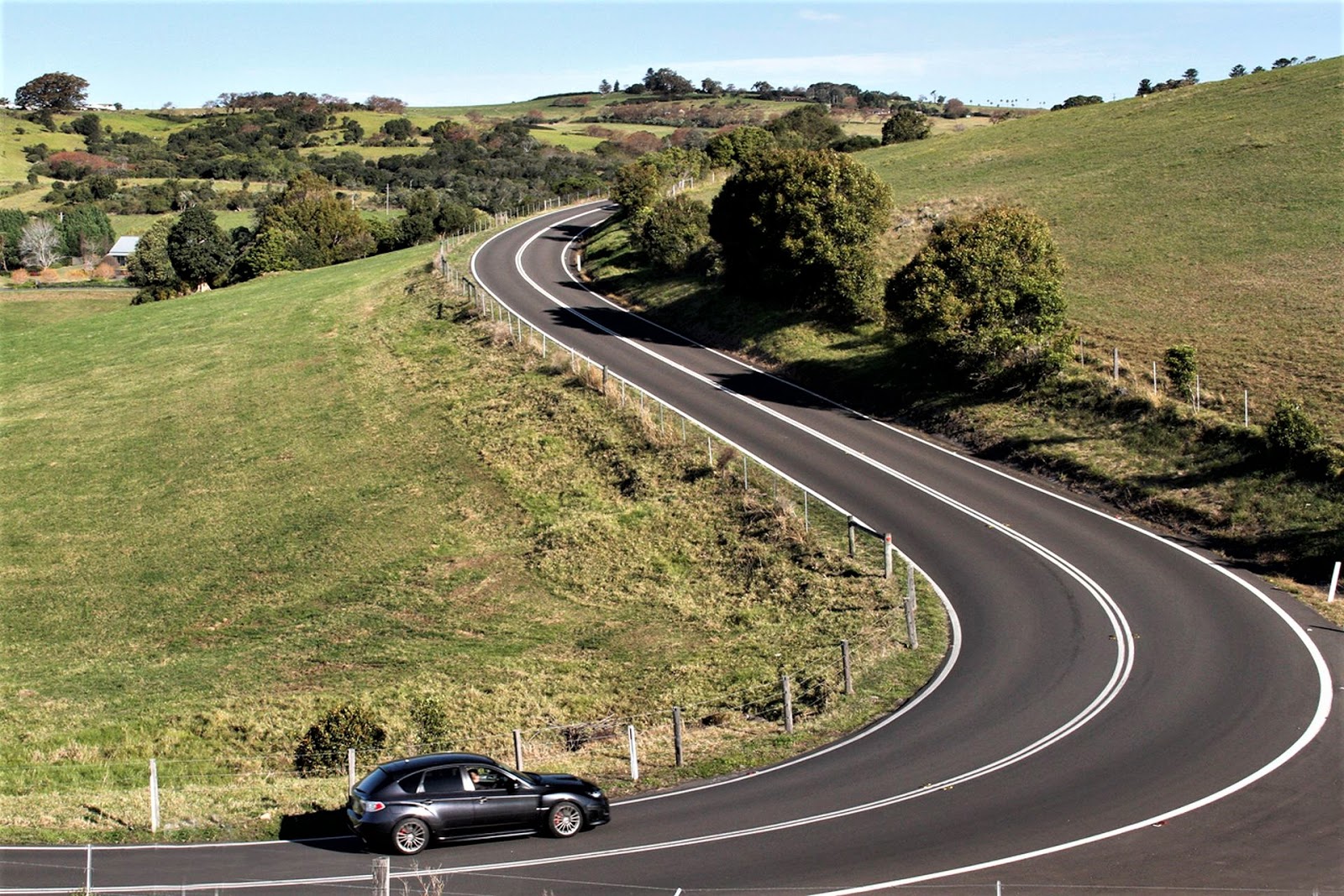
JAMBEROO ROAD - this connects KIAMA with the village of JAMBEROO 10km west. It is largely twisty and hilly, tends to be a favourite with cyclists, bikers and car nerds. If coming from SYDNEY the road by the same name 11km from ALBION PARK to the north is similar.
JAMBEROO VILLAGE - this is your typical country village, like BERRY (further south on the highway to NOWREA) was back in the day before SYDNEY trendoids discovered it. For the visitor JAMBEROO has a lively pub, a golf club and several places to find grub. The local park is sweet for picnics - also has a POOL.
JAMBEROO is 9km west of KIAMA.

MINNAMURRA RAINFOREST - this reserve is one of the southern-most examples of SUB-TROPICAL RAINFOREST. A deep gorge into the ILLAWARRA ESCARPMENT protects from the cold SOUTHERLIES and the orientation catches lots of rain.


There is a side track which leads to the UPPER FALLS - not many people go up there. It's kinda rough.
The ARRIVALS AREA has all the expected facilities.
Usual access is by car and motorcycle although this is a nice ride for keen cyclists. A local bus (#125) does come from KIAMA but only twice per day.
I must confess I haven't been up here for maybe 20 years, before which it was an annual thing - part of my schoolteacher excursion shtick (yeah I was a teacher for many years - one of many vocations). Writing this, I feel the urge to re-visit. To the rainforest - not teaching.
This area is 16km north west of KIAMA, off JAMBEROO MTN. ROAD.
JAMBEROO ACTION PARK - this is the KIAMA area's water park. On the ALBION PARK to JAMBEROO road, it's 14km from KIAMA; 4km north of JAMBEROO.

LOWER HINTERLAND ATTRACTIONS

YELLOW is JAMBEROO RD between KIAMA and ALBION PK
PALE BLUE is JAMBEROO MTN RD - is in the lowland hills until JP (JAMBEROO PASS)
HIGH HINTERLAND ATTRACTIONS - TOP OF THE ESCARPMENT
Getting a bit marginal here - many would argue that once you climb the escarpment on the narrow twisty and scenic JAMBEROO PASS you have left the KIAMA area.
But the fact is there are some interesting attractions up there - naturals for KIAMA visitors with motor vehicles to visit. And not out of bounds for keen cyclists - I have been up there on a number of occasions.
ILLAWARRA/JAMBEROO LOOKOUT
The very short access road to the right is off the main road a few hundred meters past the finish of JAMBEROO PASS (it's about 20km from KIAMA).

BARREN GROUNDS - this largish area of BUDEROO NATIONAL PARK is on the inland side of the road to the lookout - a turn in to the BARREN GROUNDS PICNIC AREA is just off the road to the left a bit closer KIAMA - to the NATIONAL PARK PARKING AREA a few km further along the main road. This is the place for trekking - there are tracks leading many ways - some go to the eastern edge of UPPER KANGAROO VALLEY.
ILLAWARRA FLY TREETOP WALK

CARRINGTON FALLS
You are really stretching things KIAMA wise, because this place is closer to ROBERTSON (11km), a sleepy Southern Highlands town, than to JAMBEROO (22km), let alone KIAMA (30km). But if you have a vehicle or are a keen biker or cyclist and have a spare day when you want to explore the larger surrounds, this place is well worth the call in.
Note it is 5km north of the turn off to the ILLAWARRA FLY.

UPPER HINTERLAND ATTRACTIONS

BGPA - BARREN GROUNDS PICNIC AREA
IJL - ILLAWARRA/JAMBEROO LOOKOUT
IF - ILLAWARRA FLY
CF - CARRINGTON FALLS
Others - R-ROBERTSON MP-MACQUARIE PASS AP-ALBION PARK
JV-JAMBEROO VILLAGE JP-JAMBEROO PASS K-KIAMA
For a linear scale - the straight line distance beween ROBERTSON and KIAMA is 25Kkm.
THE BIG LOOP - if you continue another 6km north once back on the main rd (JAMBEROO MTN RD) you will come to the intersection of the ILLAWARRA HIGHWAY. Left leads to ROBERTSON (4km), Right back to the coastal plain via twisty, busy MACQUAIRIE PASS (ALBION PARK is 22km from the intersection). From ALBION PK you can go back to KIAMA via JAMBEROO, or go another few km east to the MAIN SOUTHERN EXPRESSWAY and turn right. Seems a big deal, but with a vehicle this is a good half day or more excursionb(depending on how many places you call in to). I have also done it on a motorcycle and bicycle - in the latter case CLIMBING MACQUARIE PASS is way easier than JAMBEROO PASS. So go ANTI-CLOCKWISE.
NOTE - way back at the original intersection with the ILLAWARRA HW is the ROBERTSON PIE SHOP, well worth a call-in if you are feeling nibbly.
THE BIG LOOP

JP - JAMBEROO PASS MP - MACQUARIE PASS
YELLOW - Jamberoo Rd
PALE BLUE - Jamberoo Mountain Rd
GREEN - Illawarra Highway
WHITE - Southern Expressway (A2- Princes HW)
For scale - the straight line distance bewtween R and K is 25km
Total road distance around either loop is much the same at 73-74km.
This map is near identical to the one above it - you may ask why I didn't combine the two. Simple answer - I did this one first plus thought that putting both highland and lowland places on would overload it.
--------------------------------------
CYCLING

For visitors not keen on mixing with cars and trucks, there are also several CYCLING TRACKS - I haven't used them much, preferring the road but details can be found here.
----------------------------------------------
ACCOMMODATION
KIAMA has a full range of accommodation with the exception of A BACKPACKER'S** joint. One near the station recently closed for a new development. Apart from that you name it, KIAMA has it - from several really good camp and caravan parks (thing about KIAMA's is that you can see the ocean from them - most NSW coastal parks are separated from the ocean by a high foredune) thru rooms in pubs, Airbnb rooms/apartments/houses, plenty of the same offered thru rental agents, mid to high end resorts - yada.
**If you have read other pages of this blog, you'll be aware I am a budget traveller, always looking to stay low dollars. To this end I reckon BACKPACKERS should consider the 4 HOLIDAY CABIN PLACES in KIAMA - here 4 people sharing an ocean view cabin with all the extras will pay less each non peak than a bed in a crummy 16 bed dorm in a no-view SYDNEY street.

------------------------------------------
THE QUARRY LEISURE CENTRE and SPORTS COMPLEX.
This area is very popular with locals and visitors. The LEISURE CENTRE has a great 25m heated indoor pool and the building also has a gym, an exercise area and a big hall for balls/displays/basketball and gymnastic type stuff.
Outside the former quarry area has been converted into playing fields, a 400m athletic track, a skateboard arena and a big netball court area.


https://heysports.com.au/01978999/Kiama_Quarry_Sports_Complex
-------------------------------------------
WHALE WATCHING
Thousands of whales migrate north and south along the NSW coast each year. KIAMA with its headlands and high vantage areas is an ideal place to spot them. Over the years I have seen thousands of them (no hyperbole). Some are kms out to sea (spotted because of the almighty splash after breaching), others much closer. I have seen them within 10m of the seashore rocks.
WHALE WATCHING is a seasonal thing - May to July they are heading north: October to November, south. It seems to me they are in less of a hurry moving south and are more likely to enter bays and harbours for a look-see.
BTW - if you see one moving the "wrong way" for the time of year, no worries: it is simply a sprinter moving back to join up with its mates.

Another favourite trick is to lie on its side and bash those (sometimes 2m+ long) side flukes (fins) on the water. On still nights you often here them going BASH BASH BASH even though they may not be near shore.
Note there are WHALE WATCHING PLATFORMS on MINNAMURRA HEADLAND at the south end of JONES BEACH and on GERRINGONG HEADLAND high above the south end of WERRI BEACH - but you don't need a platform to spot them.

Some of the fishing charter boats do WHALE WATCHING CRUISES out of KIAMA HARBOUR in season.
------------------------------------------
ACCESSING KIAMA
About 98% of visitors come in by car or train. Actually - given the hoard of cyclists and bikers arriving via JAMBEROO ROAD on weekends, my percentage needs lowering.
BUS ACCESS is not a big deal - sure local buses come in from the WOLLONGONG SOUTHERN SUBURBS and PREMIER COACHES run long distance coaches from EDEN (near the Victorian border) to SYDNEY via the SOUTH COAST and KIAMA, but although popular with far south coast folk, few people use them for KIAMA.
KIAMA has a local bus service (KIAMA COACHES) - the services are not particularly frequent, but they may help people organizing transport to/from various parts of the COASTAL WALK and places in the HINTERLAND.
CAR ACCESS can be quite pleasant. If coming from SYDNEY consider diverting the short extra distance off the M1 at the HELENSBURGH exit to take in the SEA CLIFF BRIDGE on LAWRENCE HARGRAVE DRIVE. Just short of this are great viewpoints at BALD HILL and STANWELL TOPS - each not far off the main route to the bridge.

A longer diversion is to take the exit at LOFTUS in Sydney's far south to go thru the ROYAL NATIONAL PARK for some nice bush country and very twisty dirvers' roads. This can be shortened considering by exiting at WATERFALL into the National Park about 12km further south. Both these diversions go past/near BALD HILL, STANWELL TOPS and the SEA CLIFF BRIDGE.
If you stick to the most direct M1 route great lookouts can be found at BULLI TOPS and not far off the main route at MT KEIRA.
TRAIN ACCESS can be likewise spectacular scenery wise. Between STANWELL PARK and THIRROUL are some great sea views (sit on the left side of the carriage), likewise near KIAMA. There is some nice bush scenery for an hour or so thru the ROYAL NATIONAL PARK.
------------------
ATTENTION - IF YOU SEE MISTAKES OR HAVE EXTRA INFORMATION, PLEASE POST BELOW. BUT ASK ANY QUESTIONS ON THE FORUM PAGE WHICH I CHECK FAIRLY REGULARLY - WHEREAS I REVISIT THESE INDIVIDUAL PLACE PAGES ONLY OCCASIONALLY


