
BLOGGER'S BLOCK
I usually know how to start a page like this - but right now I haven't a clue.
Um.....so here's one way:
A CITY OF ISLANDS:
NYC is a city of islands - of the 5 BOROUGHS, 4 are located on islands. BROOKLYN and QUEENS are on the SW-end of large LONG ISLAND. STATEN ISLAND is self-explanatory. And of course the epicenter of the city, MANHATTAN is on that small island DUTCH colonialist originally bought from local Indians back in the day. Only THE BRONX is on the mainland.


On the right of the island is the EAST RIVER - reasonably wide in the southern half between MANHATTAN and BROOKLYN/QUEENS but in the north-east becoming the narrow HARLEM RIVER between MANHATTAN and THE BRONX (the EAST RIVER actually turns right abt. mid-map and dives into LONG ISLAND SOUND.
The yellow arrow indicates where the narrow HARLEM RIVER hits the HUDSON thus indicating the very north end of the island.
WESTERN BOUNDARY - THE HUDSON

Shot from ONE WORLD OBSERVATION DECK looking north up the HUDSON. NEW JERSEY's HOBOKEN (where Frank Sinatra was born and where baseball started) is on the left (the highrises of JERSEY CITY are to the left and behind camera). The highest buildings of the west side of MANHATTAN's MIDTOWN HIGHRISE area can be seen far background-right (they're actually the new buildings of HUDSON YARDS, some unopened at the time of shot).
SULLY SULLENBERGER landed his A 320 on river-central in this shot.
SOUTHERN BOUNDARY - UPPER NEW YORK BAY
EASTERN BOUNDARY - THE EAST RIVER (WIDE)

ONE WORLD shot showing the southern part of the EAST RIVER (nice and wide here) across to BROOKLYN - that's the famous BROOKLYN BRIDGE closest to camera.
NORTH -EAST BOUNDARY - THE HARLEM RIVER (narrow)

Getting narrow - MANHATTAN (left) and THE BRONX (right).
BACK TO THE HUDSON

That's the famous GEORGE WASHINGTON BRIDGE, the busiest in NYC and probably anywhere. The MIDTOWN HIGHRISE area is to left and behind left pillar - DOWNTOWN HIGHRISE is too far to stand out. High buildings on right are mainly residential towers in NJ's HOBOKEN.
AREAS OF MANHATTAN

If you want more detail, perhaps the following can help:

This is getting complicated - I can simplify both above a bit. Below is my idea of the main areas of MANHATTAN:

2 - SOUTHERN-MIDTOWN LOWRISE AREA
3 - MIDTOWN HIGHRISE AREA
4 - UPTOWN
5 NORTH OF UPTOWN (HARLEM and others)
ZONE 1 - THE SOUTHERN HIGHRISE AREA

The SOUTHERN HIGHRISE AREA is often called THE FINANCIAL DISTRICT although it contains a lot more than just banks and insurance company head offices etc. This is the southern and western side seen from BROOKLYN HEIGHTS just south of the bridge.

The opening shot at top of the page is very similar - that one is from the free STATEN ISLAND FERRY from only a few hundred meters to the left of above.
THIS AREA HAS A DIVERSE RANGE OF ATTRACTIONS - I SPENT AT LEAST 8 HOURS WALKING IT, PLUS EXTRA IN CAFES AND OBSERVATION DECKS. COULD HAVE SPENT MORE.
South Street Seaport


But the reason I show this shot is to emphasise the waterfront parks in this area.
MANHATTAN and NYC in general has many riverside parks - at least 50% of the island's shoreline in parkland - and pretty nice ones too. There are some great websites on NYC parks. Note how the parkland extends up the HUDSON SHORE at left.


-----------------------------------------
ZONE 2 - THE SOUTHERN and MIDTOWN LOWRISE AREA


Actually most of the above lowrise areas 2 shots up belong to LOWRISE MIDTOWN - areas of LOWRISE DOWNTOWN are closer to camera and close to right of that image (see pic below).


UNDERWHELMED - I must admit is wasn't blown away by my several hours' wander thru this zone - north west area like HELLS KITCHEN and CHELSEA I thought pretty ordinary, as were many sections further south like WEST VILLAGE, GREENWICH VILLAGE, EAST VILLAGE, SOHO, NOHO,TRIBECA. But then I'm not into trendy residentials or boutique shopping.
CHELSEA MARKETS - HO HUM

Travel guides online+print rave about this joint - I found it way yuppyfied. Probably pretty good back in the day.
BUT I MUST ADMIT I ENJOYED THE NEARBY HIGH LINE.

This walk along a converted elevated railway easement contains lotsa great views....

....such as this outlook north towards the new HUDSON YARDS development. This HIGHLINE WALK actually passes HUDSON YARDS to the left.
AS SAID, MOST CENTRAL+LOWER LOWRISE AREAS LEFT ME UNMOVED.
BUT I WAS IMPRESSED WITH LITTLE ITALY IN THE SOUTH EAST....

.....AND THE ADJACENT CHINATOWN.

THE FLATIRON - ZZZZ

------------------------------------------
ZONE 3 - MIDTOWN HIGHRISE AREA


Note the above viewpoint was a fine spot for picking if the time was okay to climb to one of the higher observation decks - the EMPIRE STATE's top (yellow) is obscured by cloud. So too is THE CHRYSLER's top (white) although that doesn't have an observation deck.
These PANORAMA pix click-expand nicely.
ONE OF THE BEST OVERVIEWS OF THIS ZONE....

Out of zone building include ONE WORLD (pastel purple) and the towers of JERSEY CITY on the opposite HUDSON shore (grey).
THERE ARE TOO MANY SITES IN THIS ZONE TO DO EACH JUSTICE. BELOW ARE JUST A FEW....


I know the travel guides say give it a miss but I found it great.
Neophytes note - the above is several blocks north of TIMES SQUARE SUBWAY STATION.


BILLIONAIRES' ROW

OTHER MIDTOWN-HIGHRISE ATTRACTIONS
There are so many other place may attract visitors' interest, like HIGH END SHOPPING ON 5TH AVENUE, THE UN AREA, and the iconic HIGH RISE BUILDINGS** yada. But I don't shop, and haven't room here for a lot of other MIDTOWN HIGHRISE places.
**but I do have a comparison of the highrise OBSERVATION DECKS down page.
-----------------------------------------
ZONE 4 - UPTOWN
We are talking about 3 areas in this zone: UPTOWN WEST SIDE, UPTOWN EAST SIDE and between them, CENTRAL PARK.


Upper West Side
You are looking at the west side of the island from 59th street (the south border of CENTRAL PARK) to 110th street. This is a fairly affluent neighborhood (but not as flash as the UPPER EAST SIDE) which also has a smattering of museums/performance areas (NATURAL HISTORY, LINCOLN CENTER), colleges (COLUMBIA U) and churches (CATHEDRAL OF ST JOHN the DEVINE)

Elsewhere in the Upper West Side you don't have any of the poverty that featured back in the WEST SIDE STORY days. It's a pretty OK area.

ELSEWHERE IN THIS ZONE
The LINCOLN CENTER is towards the south.
Stretching right along the HUDSON R in this zone is the RIVERSIDE PARK - not just walks, lawns and trees but plenty of tennis/'ball courts and similar facilities. Views across to JERSEY are pretty good.
There are several museums including that of the NEW YORK HISTORICAL SOCIETY - if you are a museum freak GOOGLE will find others.
---------------------------------------------
Upper East Side
Probably best know to visitors as the site of the MUSEUM MILE and to locals as the MANHATTAN ABODE OF OLD MONEY.
THE MUSEUM MILE
This few-blocks-longer-than-a-mile section of 5TH AVENUE along the east side of CENTRAL PARK contains 10 museums including the famous MET and the FRICK COLLECTION. I'm not a huge fan of museums but always enjoy time in the better ones - so I spent many hours wandering the marvelous MET. Lack of time precluded others.
THING ABOUT THE MET IS IT HAS SO MANY DIVERSE AREAS.


OLD MONEY RESIDENTIAL
My research indicated that the most expensive part of this zone is along 5th AVENUE because of those park views. But riverside areas are way expensive too. The areas between aint exacltly cheap either. In all, the realty value of the whole zone is higher than the Upper West Side - although those pesky NEW MONEY types have bid the best 8TH AVENUE apartments higher than on 5TH avenue.
Note that 5TH AVENUE south also has an extension of HIGH END SHOPPING out of the central CBD.
.......................................................
Central Park


---------------------------------------------
ZONE 5 -NORTH OF UPTOWN AREA

Hell, I can even see some runways of LA GUARDIA in north QUEENS bottom right.
The NORTH OF HARLEM section at the very top has the urban areas of WASHINGTON HEIGHTS, HUDSON HEIGHTS, FORT GEORGE and INWOOD.
Whoever chose the colouring of the labels needs a brain transplant - click-expand for better clarity.


.................................
The Far North of ZONE 4

--------------------------------------------------
AN ISLAND WITHOUT BEACHES
No doubt MANHATTAN had strips of silica in pre-colonial times, but today they have disappeared under shipping piers, riverside walks and other development.
So you have to go to another BOROUGH to get to the beach. The closest from most parts of MANHATTAN is ORCHARD BEACH in the BRONX.
I was surprised how nice this man-made large strip of sand backed by parkland was. I thought it the best of the 4 NYC beaches I visited. I have more on ORCHARD in NE - THE GOOD THE BAD AND THE UGLY

-------------------------------------------------------------
SO WHAT IS THE BEST WAY TO GET A GOOD IDEA OF MANHATTAN AS A WHOLE?
In 2018 I studied up books and online - when I hit the ground I used the subway, buses and shanks-pony to check the scene. But in 2019 following a lucky PAID EXCURSION experience in BOSTON I realiszd that some of these are not overpriced and some information they give can't be got elsewhere. Not to mention the humour which these tour guides are rather good at.

Tour guide NICK at Boston's HARVARD - excellent.
So I researched which reasonably price paid tours would give me the best orientation of MANHATTAN. And I came up with 2 good ones - the CIRCLE LINE AROUND MANHATTAN TOUR and the BIG BUS TOURS.
THE BEST FOR ORIENTATION - CIRCLE LINE TOUR OF MANHATTAN

Tour begins at PIER 83 - guide TOM revs up the punters....

....and the punters are not slow in getting the pix....

....like downriver a bit for ONE WORLD and nearby

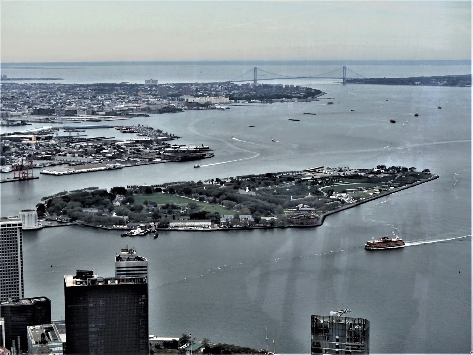
....or a bit further south in UPPER NEW YORK BAY.

Same area seen from ONE WORLD (ignore yellow arrow indicating north-west STATEN ISLAND).
TURNING NORTH WE HEAD UP THE EAST RIVER....

....and under the BROOKLYN BRIDGE - The first of many.

A bit further on, a view of some iconic central area buildings (here the CHRYSLER - cherish this, it's hard to get a good view of it elsewhere)

Not MANHATTAN, but further north where the river narrows between MANHATTAN and THE BRONX, you get to see the latter's famous YANKEE STADIUM. The previous year it took me a 50 minute subway ride to check this.

Some of those bridges over the narrow north east East River are pretty low.

Back on the home stretch - turning south down the HUDSON, GEORGE WASHINGTON BRIDGE ahead - highrise of MIDTOWN further on. Southern FINANCIAL DISTRICT highrise too far to feature.

PIER 83 in sight.
HERE'S THE THING - I finished this tour with a much better appreciation of the extent of MANHATTAN - and got to view areas in the north I am sure many visitors miss. Not to mention an increase in knowledge from the guide's vast reservoir of facts not easily found elsewhere.
------------------------------------------
THE SECOND BEST WAY TO ORIENTATE TO NYC
THE RED HOP ON HOP OFF BUS TOUR (or one of its competitors).
This is a good one - you can book online beforehand or get a ticket from one of many pavement salespeople found at most stops (rival companies reps are there too - some of those tours may also be excellent). I don't think THE RED BUS is as good an orientation as the ROUND ISLAND CRUISE because it does goes no further north than SOUTH HARLEM and if you combine all its options. is way more time consuming, particularly if you use the HOP OFF/ON option to spend time at attractions along the way (which in itself is an advantage - you can't get off and on the CIRCLE LINE CRUISE - but there are hop-on-off water taxis and other cruises). And the bud routes are designed to pass by all the major MANHATTAN attractions.

In high season there can be considerable lines waiting at popular spots (this is the CENTRAL PARK stop) for the next bus (these start the day 10 minutes apart but naturally gaps stretch and shrink over time). I hate lines and just stayed on the bus for the whole circuit - despite this I found both DOWNTOWN and UPTOWN loops took over 2 hours each.

Bus approaches TIMES SQUARE. From this shot you can appreciate the advantages of buying a trip on the day - if pre-booked the day could be rainy and there is only limited sheltered seating.

Approaching the CHRYSLER.
THE UPTOWN CIRCUIT

Moving up 8TH AVENUE alongside CENTRAL PARK

RIVERSIDE CHURCH is southern HARLEM
IN ALL - you could do your whole NYC visit based on this bus. Pick the sites you want to see and which hop on hop off bus circuit (DOWNTOWN-UPTOWN-BROOKLYN etc) goes by. Then either buy your ticket online or on the day(s).
But you must take care to give yourself time for all this - my mistake was buying a full ticket with ALL ROUTES + BONUS CRUISE with only a day and a half to fit them in. As I said, just staying on the bus is time consuming. Then getting between major starting points takes time (they start at different points although there are some common stops to simplify transfers if you plan carefully. Plus some tours start at limited specific times which makes it hard to transfer from one loop to these). Way it half-worked for me is I fitted in the DOWNTOWN-UPTOWN loops plus the BONUS CRUISE**, biy had to give the BROOKLYN LOOP and the NIGHT LIGHTS TOUR a miss.
**My ticket's BONUS CRUISE was from pier 86 into UPPER NEW YORK BAY - so we saw much the same things as the first 25% of the AROUND ISLAND CRUISE. Despite this I enjoyed it - you never tire of sights like the FINANCIAL DISTRICT or STATUE OF LIBERTY from the water plus the tour guy had a whole lot of new info and gags
.
But from what I can see these companies are fluid in their offerings - the latest online stuff is a bit different from that on offer summer of '19.
TIPS - if you have time, a good way to tour is to start early, do the whole loop on the bus, stay on and get off/on at your desired stops second loop.
- if time/money limits you to one tour, I'd suggest the DOWNTOWN LOOP.
- to save time between loops it may be best to stay on the bus part of an extra circuit to where it intersects the other loop.
- you don't have to start a loop at the first stop. You can jump on at any stop along the way, get off where you like.
------------------------------------
GETTING AROUND
As a budget traveler, I eschewed taxis, uber etc and used the subway and buses, both of which MANHATTAN has an excellent system. When wanting to cross to QUEENS, THE BRONX or JERSEY I also occasionally used the RIVER TAXIS which also have a good inexpensive system.
THE SUBWAY
Sure it's initially confusing, often crowded, hot, noisy and dirty but once I sorted things I really appreciated its frequency ,multiplicity of trains/lines/stations and the lack of expense.

Can get busy - TIP: avoid peak hour if possible. But peak NYC is more than one hour both am/pm.

Not very crowded on this off-peak service.
GENERAL SUBWAY ADVICE
-There is a whole bunch of online stuff both official and unofficial which give invaluable info.
-Do your research pre-trip re the best subway ticket for your stay. In 2018 I used an unlimited METRO CARD but that didn't work out for my 2019 visit with more but shorter stays in NYC.
- pick up a METRO MAP from any ticket office at most stations (patrons tend to use the ticket machines so the offices are usually uncrowded). These maps are invaluable in planning next activities.
........................................
THE BUSES
NYC has a brilliant bus system. I didn't use it all that much simply because the SUBWAY does such a good job. But locals ride a lot.
One LONELY PLANET guidebook suggestion I found a good one - I hopped on a northbound bus in the FINANCIAL DISTICT, the aim being to stay on until the route's conclusion - this was somewhere up in THE BRONX. I crossed the road and hopped on the next bus heading downtown. Its destination was SOUTH KEY, but when we arrived at TIMES SQUARE things were jumping - so I bailed out.
THING IS THE BUS GIVES WAY BETTER VISUAL REFERENCE TO AREAS than the subway. I guess the same can be said for taxis/uber - but they were above this octogenarian tight-wad's pension grade.

ROOSEVELT ISLANDS FREE RED BUS tends to pack them in....

....but that return city bus from THE BRONX mentioned just up page was way less crowded. Mind you this was not near peak hour.
THE WATER TAXIS
There's a whole bunch of frequent services across/along both rivers at reasonable rates - very scenic.


-----------------------------------------
GETTING FROM THE AIRPORT
I have come in to NYC by aircraft, bus and train - but for overseas arrivals it's gonna be via the airports - JFK, LAGUARDIA and NEWARK, NJ**. Of these I have used the first two - the thing is they are not in MANHATTAN and so you have to transfer across.
Once again there are great official and unofficial guides online with good advice abt the multiple modes of transport to use and how/where to get tickets etc. But for single budget travellers like me, the AIR TRAIN-SUBWAY option from JFK and the BUS or BUS-SUBWAY option from LAGUARDIA is the go.
Which is cheaper? LAGUARDIA but JFK will not break the bank. LAGUARDIA is also a shorter trip.
**fewer overseas arrivals.
AIR TRAIN

....runs frequently, is clean and not particularly expensive. Take advantage of the helper-staff where it meets the normal subway network - these people give great advice re the best train to your destination and the best ticket to use. They even ran me through how to get an UNLIMITED RIDE TICKET from the machines - a pretty simple process for non-octogenarians.
-----------------------------------------------
ATTENTION - IF YOU SEE MISTAKES OR HAVE EXTRA INFORMATION, PLEASE POST BELOW. BUT DIRECT ANY QUESTIONS TO THE FORUM WHICH I CHECK REASONABLY FREQUENTLY WHEREAS I SELDOM GET BACK TO THESE INDIVIDUAL PLACE PAGES.


1 comment:
شركة تخزين اثاث بالدمام
شركة نقل عفش من الرياض الى الدمام
شركة نقل عفش من الرياض الى المدينة المنورة
شركة نقل عفش من الرياض الى ابها
شركة نقل عفش من الرياض الى جازان
شركة شحن عفش من الرياض الى سلطنة عمان
شركة شحن عفش من الرياض الى البحرين
__________________________________________-
Post a Comment