visited September 2018
THE HAMPTON BEACHES - UPPER LONG ISLAND

The HAMPTONS region takes up about the eastern-most third of LONG ISLAND. There had been much debate (rec. read - some amusing comments) about whether a place is in the HAMPTONS or not - but the general consensus is anywhere east of the SHINNECOCK INLET/CANAL is in these days EXCEPT for SHELTER ISLAND (maybe all that hoi poloi partying upsets the sensitivity of the rich dudes). Note WESTHAMPTON west of the line misses out - from what I can gather many of its residents are glad not to be associated with over-rich "citidiots".
Originally the HAMPTONS was regarded as that area around the towns of EAST HAMPTON and SOUTH HAMPTON but over the past 50 years more and more rich folk from NYC looking for a not too distant beach/near-beach escape have expanded it to its present size.
Note SOUTH ARM and NORTH ARM. The latter is way more rural but because it has WINE GROWING and wide open spaces for the big country retreat, has equal cachet with the snobs.
OVER-HYPED and OVER-PRICED.
My take on the HAMPTONS:
These past 50 years I've read heaps about New Yorkers escaping to THE HAMPTONS for an upmarket weekend or holiday - how very rich dudes have the BIG ESTATE there. I thought this must be somewhere VERY special - maybe a bit like the COTE D'AZUR.
It 's NOT.
By world standards this is a very ordinary area with pretty underwhelming countryside (most of LONG ISLAND is the result of glacial outwash and sand deposition so you are looking at fairly flat very ordinary countryside - UPPER NY STATE kills it with some genuinely lovely areas) and ordinary beaches (none I saw would make my top 1000. Hell the best wasn't as good as the worst of the 4 in my home town (pic down page) - and THAT wouldn't make my1000).
But the thing is all those rich dudes have bid up the price of real estate and hyperboled the pretense that this is somewhere very special. By world standards it's not. I can think of dozens of places in the GREEK ISLANDS and SPAIN alone would kill it.
The giggle is, thanks to Australia's ridiculous real estate boom, I could sell my fairly modest seaside home not far from SYDNEY and buy a pretty good HAMPTONS' joint - not one of those huge trophy spreads but far better than the average. And I'm a retired dude on a very skinny part-pension. Take that NYC rich poseurs.
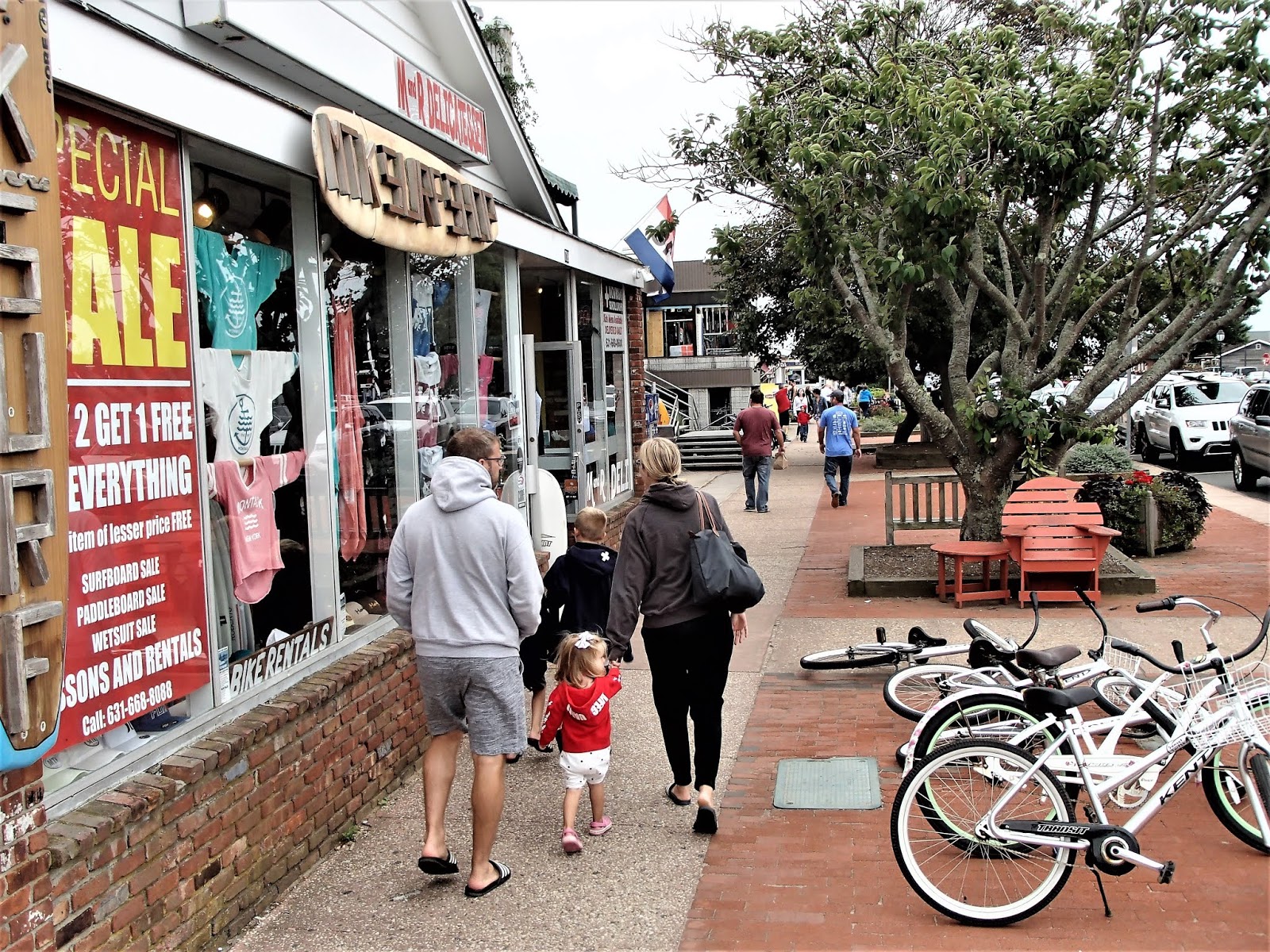
MONTAUK BEACHES

Montauk is as far east as towns go at LONG ISLAND/THE HAMPTONS. It's a bit over 3 hours by train from MANHATTAN - and abt 120 road miles. 20 years ago it was considered a dormitory area for HAMPTON service workers, but the inevitable expansion caused by trendoids seeking a beach escape place has it now firmly entrenched as part of the real deal.
UNDERWHELMING MONTAUK BEACH

Note the relative lack of beach goers early afternoon on a nice SEPT Sunday - but we are talking maybe 2 weeks after LABOR DAY, the official end of summer - and several sources said people just STOP going to the beach after Labor Day. This is a bit of a surprise to me - from my travels in OZ, the MEDITERRANEAN and SE ASIA I've found the month or more after HIGH SEASON (what we would call SHOULDER SEASON) is an excellent time for low budget dudes to travel - weather is still excellent and prices/vacancies way lower. Seems NE US has no Shoulder Season.
What worries me above are those dune-perched motels and units - next super storm they face storm surges with the associated wave attack and undermining. Thing is this FORE-DUNE is pathetic protection-wise by world standards - central MONTAUK is just behind and faces inundation.
There are precedents - EG several communities on a similar stretch of FIRE ISLAND beach (to the south of MONTAUK)_have lost first row beachfront residences to STORM SURGE/WAVE ATTACK during SUPERSTORM SANDY in 2012. As recent as MARCH 2018 the "new" beachfront properties suffered bad storm wave cut.
MONTAUK VIA GOOGLE EARTH


From here the beach continues 110mi/180km west - past inlets like SHINNECOCK mentionsed above, along several BARRIER ISLANDS. all the way to CONEY ISLAND/ROCKAWAY BEACH near JFK.

IN GOOD TIMES

OK, so it shows DITCH PLAINS some distance east of my pix - but DP is still a MONTAUK BEACH - I find most interesting the crowd - obviously HIGH SEASON before LABOR DAY.
Now here's the thing - plenty of people may come and have a great day under idyllic conditions - I'm thinking one of those high-summer days with a hot light offshore breeze blowing. And afterwards some dude from the upper west side doesn't get to the beach often fires in a TRIPADVISOR review saying MONTAUK BEACH is the best beach in the world. It's not. By a long shot.
MONTAUK TOWN.

MY MONTAUK ACCOMMODATION
I kinda thought post LABOR DAY and a Sunday night would get me some discounted accommodation. But as mentioned up-page, Montauk places tend to be EYE-BLEEDINGLY EXPENSIVE. Like airbnb places at a thousand a night?? Shoulder season??
The only place I found at a somewhere acceptable price was DAUNT'S ALBATROSS MOTEL Even then, I ended up paying the most of my 4 week NE US trip which included a night at an ANTLANTIC CITY CASINO. A few steps up from DAUNT'S.

CONCLUSION - some of you may be thinking I was less than gruntled about MONTAUK. Not wrong kemodabes. Pretentious poseurs' paradise.
............................................................
EAST HAMPTON BEACH.
In my pre-trip research I found a NEW YORK POST article claiming EAST HAMPTON MAIN BEACH was the BEST IN THE USA. Jeez, I thought, have to check THIS out!
So I jumped off the bus from MONTAUK at EASTHAMPTON RW STATION and started the 2mi/3.2km trek to the beach (bottom budget travellers don't catch taxis). Trouble is it was raining and 5 minutes into the walk POURING, with gusty winds making the H20 come sideways. I HATE THAT!! - so I gave up, retraced my steps and jumped on a waiting bus to PATCHOGUE abt half way down LONG ISLAND where I had an airbnb room booked prior to going out to adjacent FIRE ISLAND next day.
So I can't tell you too much about EAST HAMPTON MAIN - I'll give you some pix I found and my impressions of them.

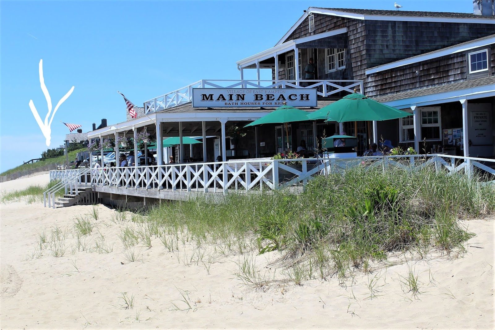


TO SUM UP - I'm not sure. Seems to me I've seen heaps better beaches in the USA - a couple on the west coast, one (CAPE MAY) on the east coast (but I haven't been to FLORIDA and nearby states yet) and several in HAWAII. The guy doing the rating is STEPHAN P LETTERMAN aka DR BEACH who loses a lot of credibility with me by rating HAMOA BCH on MAUI #2. Second best beach in the US? Hell, I thought at least a dozen other MAUI beaches way better. And nearby OAHU has at least another half dozen.
MAYBE YOU CAN HELP - I feel a bit of a phony judging a beach I've not visited. Thing is at 73yo and 10000mi/16000km from EAST HAVEN I can't see me making a return trip to check it out. So if any reader does, feel free to lob in a report, maybe some pix via the prompts on the TRIP REPORTS PAGE. Or to keep it simple, a description via the COMMENTS section at the foot of this page. I'll transfer your input (whether you agree with me or not) up to this section of the page.
STOP PRESS - coincidentally an email about TRIPADVISOR'S TOP 25 WORLD BEACHES 2018 lobbed into my inbox when writing this page. Some of those places look idyllic. But I'm a bit sceptical about others. LA CONCHA at Spain's San Sebastian #6? Been there, was undewhelmed. I visited a dozen Spanish beaches better. BOURNEMOUTH England #14? MANLY Sydney #16? Sydney alone has a half dozen better, Australia hundreds.
TRIPADVISOR doesn't explain its methodology but judging by some of these selections it seems it could be on the number of reviewers' EXCELLENT ratings or maybe something slightly more sophisticated like reviewers' EXCELLENT ratings per 100 reviews. Anyway I've always thought readers' ratings a bit dodgy - too many seem to use the system as an affirmation of their marvelous choice and dish out EXCELLENTS to places which in no way deserve them.
MY TOP BEACH WORLDWIDE
I can hear you thinking this TEZZA dude is way critical - so what is his idea of a world class beach? See below:
WHITEHAVEN BEACH - HAMILTON ISLAND - QUEENSLAND

HAMILTON ISLAND looks flat in this shot but is quite mountainous - with many patches of tropical rainforest.
Pic from WHITSUNDAYS AUSTRALIA com

Note I usually prefer compact beaches which 6km IS NOT - but this place is a standout.
Note too I may be a bit presumptuous claiming WORLD'S BEST when I haven't seen all the world's top beach areas - some of those on the TRIPADVISOR list look pretty good to me.
MY PERSONAL FAVOURITE BEACH

This beach ticks all the boxes for me: it's compact between 2 protective headlands, backed by rainforested slopes, gets good surf, few people because of difficult access and is clothing optional like most beaches in this area (I've been a naturist since childhood).

If you ever visit be aware of rip-currents both ends and usually 2 or 3 along the beach. No worries, relax and go with the flow, stick your arm in the air to attract the few surfer dudes who are usually hanging around here. An ok rock pool in rocks (der) top end.
FUN FACT - there have been several shark attacks this section of coast (not this beach) in recent years. The good news - only one fatality.
WORST BEACH IN MY HOME TOWN

Bottom of my town list because it rarely attracts decent surf....and is not clothing optional (nor are the other 3). Although I once saw 2 young ladies....
Best feature is I live overlooking a nice little bay 300m from the far end.
CENTRAL LONG ISLAND BEACHES
FIRE ISLAND - DAVIS PARK-WATCH HILL BEACH

The above is part of the beach which starts a few km west of MONTAUK runs more than 100miles/160km down the Atlantic side of LONG ISLAND to near JFK in south QUEENS. In some sections it dives across inlets as BAY-HEAD BARRIERS to create what coastal geomorphologists call COASTAL LAGOONS. We would probably class them as COASTAL LAKES. In other areas the coast kinks a bit inland and the sand continues in a straight line as as the seaward side of an offshore BARRIER ISLAND running parallel to LONG ISLAND (the whole barrier island is actually sand built up from millions of years of deposition) separated from the land by a stretch of sheltered water. Because of tidal and river flows there are gaps in these offshore barriers - SHINNECOCK INLET mentioned up-page is one.
NOTE - you tend to get BARRIER ISLANDS on coasts with relatively shallow water offshore. They are a major feature of the US Atlantic Coast and the Gulf of Mexico.
FIRE ISLAND is one of the more eastern of LONG ISLAND's barrier islands.

DAVIS PARK is 4.5mi/7.2km from the ferry pier in SOUTH PATCHOGUE.
FIRE ISLAND is over 22mi/38km long but very narrow like most barrier islands - only 350yds/320m at DAVIS PARK.
Bay is a different colour than ocean because it is much more shallow. These bays can fill in over time - this appears to be happening in several spots along the JERSEY SHORE south of NYC


Sea mist still hanging around on arrival at DAVIS PARK MARINA abt 0930 - soon burnt off.

THOUGHT - I wonder how much of the above flooding may be due to FRESH WATER run-off from storm-filled"mainland" (Long Island) rivers and streams, which can't get out to sea thru the narrow gaps between the barrier islands fast enough?
Maybe the storm surge on the ocean side wasn't as high (although if you click the above link, the storm wave damage was),
Thing is we don't have barrier islands where I live and so I don't know much about this stuff.

The western end of FIRE ISLAND is about 8km/5mi up there in the mist.
As you can see the beach (at least in mid SEPT 2018 is nothing to get excited about. Narrow (check the high tide mark - I'm glad I didn't have to walk the 1300m/1430yds up here from DAVIS PARK at high tide [actually there is a path behind the fore-dune]), plenty of weed debris not all that attractive.

As you can see plenty of new timber on the structure suggesting damage in the March storm.
Beach hasn't rebuilt much - check the high tide mark.
At least the fore-dune here is a bit higher than at MONTAUK.

Thing that gets me was how the area had not rebuilt much after the March storm 6 months before. Compare the above to the newsletter pic below....

Arrow shows storm wave "cut" on fore-dune - which doesn't appear as high as along the beach at WATCH HILL. But that happens when you build on dunes.
A lady in PATCHOGUE told me she used to holiday in a dune-front place on FIRE ISLAND back in the day but the whole street disappeared with SUPERSTORM SANDY. The above may have been one street inland.
NOTE - THIS IS A WORK IN PROGRESS, SHOULD BE FINISHED IN A FEW WEEKS.
tezza OCT21.
DAVIS PARK DAMAGE MARCH 2018
SANDY


2 comments:
thank you for sharing this awesome article. i am also impressed to read
https://marketbusinesstech.com/famous-top-9-best-beaches-u-s-travel
it is the best and informative about the beaches in united states
n9j61l2j18 o2n70l9h67 d5x19r2p03 k3w20g7o09 u8d63t7x12 p6q22t4w39
Post a Comment