Tuesday, May 15, 2018

THE KAIELIA TRAIL

THE KAIELIA TRAIL (and adjoining trails).

done APRIL 2016

ATTENTION: THIS IS A PRETTY LONG PAGE WITH SEVERAL TRAIL DESCRIPTIONS. IF YOU HAVE BEEN SENT HERE BY A SEARCH ENGINE LOOKING FOR ONE PARTICULAR TRAIL, YOU WILL FIND:
KAIELIA TRAIL - immediately below
MOKULE'LA (MOKULEIA) ACCESS ROAD - abt. 40% down page
KUAOKALA ACCESS ROAD (EAST) - abt 60%
KUAOKALA ACCESS ROAD (WEST - 75%
KUAOKAL (RIDGE) TRACK - 65%
and PEACOCK FLAT CAMPING AREA - abt 55% down page


The KAIELIA TRAIL is in western OAHU and goes from the coastal west of the NORTH SHORE into the WAI'ANEA RANGE. In this part of the island the WAI'ANEA separates the southern part of the north-west coast (known locally as the NORTH SHORE) from the rain/trade winds sheltered northern part of the south-west coast (known locally as the LEEWARD COAST)


The WAI'ANEA RANGE is the western range of mountains on AOAHU, running almost parallel to the eastern KO'OLAU RANGE. It contains OHAU'S highest peak - KA'ALA (4025FT/1217M) - image Go Hawaii


THE KAIELEA TRAIL
This is the most used trail in the area because:
* parking behind DILLINGHAM AIRFIELD is better than at other trailheads
* it offers a not too lengthy (2.3mi/3.7km one way) up and back trek which is steep and rough enough to satisfy users they have had a good hike - but not overly so. It won't worry people of average fitness providing they make a few rest stops. The trail is well defined and easy to follow and not technically difficult underfoot.
* views back over the western NORTH SHORE are definitely the best of any trail and by pushing on a bit further via connecting trails it is possible to get overviews of the LEEWARD COAST.
*people seeking a longer trek can continue via several trails to either eventually loop back to the KAIELEA for a descent back to DILLINGHAM or push on to stay overnight at PEACKOCK FLATS CAMPING AREA.
It is also possible to walk all the way to the southern LEEWARD COAST at YOKOHAMA BAY in the far west by descending the access road to the KAENA TRACKING STATION which is in this mountain area further west (see down page), but a permit from the DIVISION OF FORESTRY AND WILDLIFE is needed for this road.

KAIELEA TRAIL
On far western OAHU the WAI'ANEA RANGE separates the western end of the NORTH SHORE from the western end of the LEEWARD COAST. The KAI'ELEA TRAIL traverses all but a small section of the range.
Main road 930 along the NORTH SHORE is the FARRINGTON HWY from HALEIWA abt 8mi/13km to the east of the airfield. It ends abt. 2mi/3.3km further west but it is possible to take a trekking trail another 2.5mi/4km to the far western tip of the island at KAENA POINT.
Main road 93 along the LEEWARD COAST is also the FARRINGTON HWY (I guess the aim is to sometime join north and south sections in the KAENA POINT area) running all the way from the western suburbs of what is considered GREATER HONOLULU abt 21mi/34km east of its western end some 2mi/3.3km from KAENA POINT. Once again a walking trail goes to the point.
Pic details may be clearer if you click-expand image.

The trail starts in the south-east corner of the spacious and free parking area on the inland side of the airfield. After a flat few hundred meters it begins to climb WAI'ANEA'S steep northern escarpment.


This great shot from T0-HAWAII brings out the steepness of the highland escarpment behind DILLINGHAM AIRFIELD.

The trail up the escarpment gains 950/1000ft (290/305m) in around 0.8mi/1.2km but because of 19 switchbacks, the slopes from moderate to steep never become ridiculously steep. Fit people will charge right up, normal types may need a stop or two - but this is no problem because there are many excellent photo opportunities over the western NORTH SHORE.

I shot this from maybe 3/4 the way up the slope - yellow arrow is of course DILLINGHAM AIRFIELD, white the track. An added bonus at times is glider and parachute activity - the airfield hosts both.
Please excuse the clumsy stitching of images via my elcheapo OLYMPUS's 'panorama' setting. These panorama shots usually click-expand nicely.


The coast a bit further to the west from roughly the same camera position. Notice shower out to sea - it wasn't a particularly nice day.

The escarpment track is not very wide but never becomes a bush-bashing exercise. Underfoot are plenty of rocks, roots and gravel - I reckon good shoes are a bonus here but was amazed at the number of people passing the other way wearing sandals and flip-flops. It looked like plenty of folk had decided on a quick mid afternoon up-and-back after a morning on the beach. 
This trail was much busier than others in the area - I passed at least a dozen people on the hour or so I spent DESCENDING the KAIELEA (I did it as a LAST section of a much bigger trek starting further east - see TEZZA'S CIRCUIT down page) whereas in the previous 5 hours I had only seen 3 other trekkers, 2 cyclists and 3 off-road vehicles. I negotiated plenty of single step-downs but my 70 year old shot knees appreciated the lack of flights of stairs.

The upper part of the KAIELEA changes markedly. South of the escarpment edge  it becomes much flatter (actually it undulates with the general gradient gradually up-hill) is relatively straight and widens into a gravel-surfaced road, probably part of the upper area's fire trails.

ON TO VIEWS OVER THE LEEWARD COAST.
The southern end of the KAIELEA joins the KUAOKALA ACCESS ROAD at a t-juncion. Take a left and continue a few hundred meters to the start of the KUAOKALA RIDGE TRAIL (from memory is is signposted 'KUAOKALA TRAIL' - no 'RIDGE') A short distance along is a gate thru which is the first of several overviews of the LEEWARD COAST.


First view of the LEEWARD COAST - the MAKUA VALLEY north-west of MAKAHA which is apparently a military reserve so it may not be a good idea to try over-landing to down there.


My shot above this is suffering from bad weather setting in. This much clearer pic comes from DOBBS: on walkabout - this great site is really worth visiting: has a host of excellent pics of the KAIELIA plus much more detailed route instructions.


But I didn't come UP the KAELIA TRACK - I approached the above area as the LAST part of TEZZA'S BIG WAI'ANEA LOOP (for want of a better name).....

(THERE IS ANOTHER KAIELEA MAP AND ONE MORE OF DODDS GREAT PICS TOWARDS THE FOOT OF THE PAGE).


TEZZA'S BIG WAINEA LOOP
START at "start" (der) top right. Go up TRACK #1 (white) - at the MOKULE'LA ACCESS ROAD. At the top is a road barrier - past here head west on the KUAOKOLA ACCESS ROAD EAST (purple # 2) -until the sign to the left for the KUAKOLA RIDGE TRAI (pale purple #3). At the western end rejoin the KUAOKOLA ACCESS ROAD (in this case the WESTERN SECTION - indigo #4).Walk some 55/65 minutes back east and you will find to the left the junction of the KAIELEA TRAIL (yellow # 5) down to the DILLINGHAM AIRFIELD.
The whole 15+mi/25km trek took me just under 6 hours, and I teamed up with a dude about 20% in who walked much faster then my usual geezer's shuffle.
Once again map details will be clearer if you click-expand image.


MOKULE'LACCESS ROAD - also spelled Mokuleia Access Road
I took this more eastern (3mi/5km) route into the mountains simply because it was closer to the nearest bus stop (in the coastal village of WAIALUA) by 2mi/3.2km. And I was in luck - I managed to hitch a ride from near the bus stop to the trail head.
At the trail head is a locked green gate with enough parking for a half dozen vehicles - plenty more along the adjacent FARRINGTON HWY which is a good 2 lane blacktop here.
BEWARE - island websites say theft from cars is high in this area - don't leave valuables in the vehicle: some even urge windows left down and glovebox open (less than half the parked cars I saw in several visits along the FARRINGTON did the latter).


The 3.5mi/5.8km MOKULE'LA ACCESS RD goes from the FARRINGTON HWY up to a gate just short of the PEACOCK FLATS CAMPING AREA.

Highest peak in this modified GOOGLE EARTH image is also OAHU'S highest - MT KA'ALA (40023FT/1217M) - GOOGLE MAPS shows a road/track up there from a bit further east (left - in this image because you are looking DUE SOUTH, not the usual DUE NORTH) on the FARRINGTON, but I don't know how good this is for driving/trekking - perhaps next visit.
WRONG!! Some time after writing the avove I came across a terrific MT KA'ALA trek account from DODDS on-walkabout - seems the hiking trail leaves from the opposite LEEWARD COAST. 

The short road from the FARRINGTON down to WAIALUA can just be seen at far left.

Behind the locked green gate at the FARRINGTON HIGHWAY (from what I can gather only official FORESTRY AND WILDLIFE vehicles have access, but there is plenty of room for trekkers and bicyclists to pass) is a wide sealed road which tends to be flat and fairly straight for a km or so before the escarpment. This is less sheer than further west behind DILLINGHAM AIRFIELD - slopes vary from moderate to fairly steep but never killer. There are a number of bends but no tight switchback-like as further west. The sealed surface continues to the top but there were a few deep potholes higher up, something cyclists descending at warp speed and trekkers coming down in the dark without a torch (in this respect it would be a much better descent for late trekkers than that into DILLINGHAM which is too narrow and rough in the dark) need to watch for.
Two cyclists, one official vehicle and zero trekkers passed me the other way while I was ascending for abt an hour at my geezers' pace.

There are several good viewpoints along the MOKULE'LA, but not as many nor as good as from the KAIELEA. This one was from near the top - showing mid and northern NORTH SHORE locations: HALIEWA (yellow arrow), WAIMEA BAY - the southern most of the NORTH SHORE'S more famous big wave locations (white arrow), the northern end of the NORTH SHORE a few km past legendary SUNSET BAY (charcoal arrow) and closest camera; WAIALUA (red arrow).


PEACOCK FLATS CAMPING AREA

To the left of the locked gate at top of the MOKUKE'LA is this meadow. Empty here but I think this may be an overflow area - websites talk about each camp-site having a permanent shelter plus picnic tables, an outhouse (but no water) so I think the main camping area is back to the right. A couple walked up while I was studying an info board behind camera - told me they were the only campers. It was mid-week.
This looks like a nice campsite surrounded by pines and eucalypts and with good views back over the north shore. It is popular with off-roaders (who drive in via the TRACKING STATION), trekkers, cyclists,, hunters (much of the general area is made up of hunting reservations - don't wander too far off the tracks) and other outdoors types. Note you need a camping permit from the DIVISION OF PARKS AND WILDLIFE. Apparently the area can get quite busy on nice weekendss.


EAST KUAOKALA ACCESS ROAD
This begins immediately the other side of the closed gate at the end of MOKULE'LA ACCESS ROAD and runs for 2mi/3,.km (perhaps a bit more) to where the KUAOKOLA (RIDGE) TRAIL is signposted to the left. It is gravel surfaced, twisty and undulatiing - but with no killer slopes Initially the general direction is south-west towards the edge of the ridge and then it runs westward along or close to the edge for over a km. Surface was pretty good, although I have seen pix of off-road vehicles (this is the last stage of the access road from the TRACKING STATION to PEACOCK FLATS for vehicles who have come up  from YOKOHAMA BAY on the LEEWARD COAST) having a terrible time in cut up surfaces after heavy rain. 
One private off-road vehicle and one trekker passed the other way the 30 minutes spent along here.
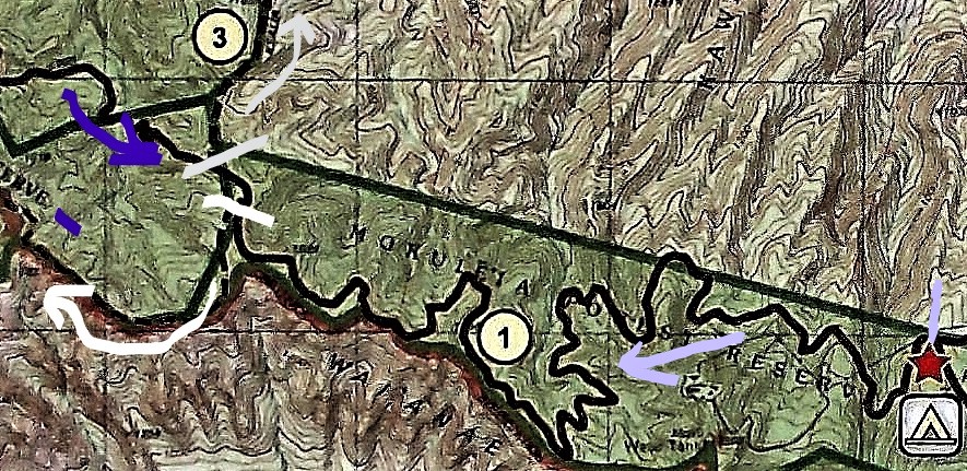
Stage 1 of my trek on the KUAOKALA ACCESS ROAD EAST (#1) started at the far right pale-purple mark at the junction o the MOKULE'LA TRAIL (notice the camping sign for PEACKOCK FLATS) and ended at the white mark at left, where the KUAOKALA (RIDGE) TRAIL (white arrow) takes off to the West.
A few hours later I returned on the roughly parallel KUAOKALA ACCESS ROAD WEST (indigo arrow) and turned down the KAIELIA TRAIL (grey/silver #3) towards DILLINGHAM AIRFIELD.

The above is modified from an information board map erected near the eastern start of the KUAOKALA ACCESS ROAD. 
It was here I met another trekker who had come up from DILLINGHAM AIRFIELD. He planned to return via my proposed route along the RIDGE TRAIL and asked if I wanted to join him. Now I'm a bit of a loner but all the guides say don't hike alone, so I joined in. Turned out real well on account:
*he was a young bloke and walked 50% faster than my geezers' shuffle which allowed me to cover the ground in much less time than originally thought, particularly since like me he didn't believe in rest stops, except to snap pix. I think he was a bit surprised how I kept up on the many steep pinches along the way, but the fact is I'm a very fit old geezer.
*he had real good bush sense and seemed to take the correct track junction every time (he swore he had no prior experience of most of our route) whereas I only manage it one in three (I kid you not).
* he had his car at DILLINGHAM and I hoped to hook a ride with him back to the bus stop. Turned out even better - his home was in HONOLULU and so he could drop me on the outskirts of HALEIWA (I was staying in HALEIWA) along the way.

Pretty good information board at PEACOCK FLATS junction.

There are several good overviews of the lower NORTH SHORE along the EAST KUAOKALA ACCESS ROAD but the weather was setting in and my view was largely obscured by cloud. 
We were lucky,it  only rained slightly so the roads and tracks didn't become muddy.


THE KUAOKALA (RIDGE) TRACK
Let's distinguish this from the similarly named KUAOKALA ACCESS ROAD. The latter which for its western half runs roughly parallel a short distance inland to the north is a gravel road wide enough for two vehicles in most areas whereas the RIDGE TRACK is just that, a trekking track along the edge (or very close) of the ridge, too narrow, twisting, steep in parts, and rough for vehicles. It tended to have lots of rocks, roots and loose stuff underfoot. I reckon the steep pinches and rough surface would be too difficult for most cyclists.
However at no time did I think it too difficult for the average trekker - in fact normally the bonus of several good viewpoints down over the LEEWARD COAST would make this the better option for people heading west towards the TRACKING STATION. However the bad weather made views fleeting.

Doesn't look good.

The best view of the LEEWARD COAST I got thru a break in the clouds.

Our 2.5mi/4.0km/55-65mins westward trek along the KUAOKALA (RIDGE) TRAIL (white arrow - #2) started at the white junction lower center and ended at the junction with the western start of the KUAOKALA ACCESS ROAD (indigo - #1) near the top left corner.
The far left road coming up from the south indicated by the red arrow is the permit-only TRACKING STATION access road from YOKOHAMA BAY.

We saw no other people along here.


 WEST KUAOKALA ACCESS ROAD 

We began our 50/60 minute eastwards trek back along the WEST KUAOKALA ACCESS RD (indigo #1) at its junction with the RIDGE TRAIL at the indigo mark top left. 

I remember the transition was pretty seem-less - but I don't remember seeing any spaced-out structures (the TRACKING STATION is pretty close) or even the parking area near the junction (this would be ideal for permit holders who have driven up from YOKOHAMA BAY and intend to trek the RIDGE TRAIL-WEST KUAOKALA RD loop.
The latter was very similar to its EASTERN SECTION - winding and undulating but never excessively steep, surface okay gravel and supposedly occasional glimpses of the NORTH SHORE which we didn't see because of the weather.
After about 2mi/3.3km (maybe a little more) we reached the T junction to turn left down the KAIELIA (yellow #3) to DILLINGHAM.

We saw 1 other trekker and one (private) off-road vehicle along WEST KUAOKALA RD.


THE FINAL LEG - DOWN THE KAIEL1A TO DILLINGHAM

I have already given details of this trail up page - suffice to say going DOWN it at the end of a very long day was pretty good. We made great time and I found myself at the DILLINGHAM AIRFIELD PARKING AREA nearly 6 hours after starting further east of my starting point at the MOKULE'LA ACCESS RD trailhead.

Unfortunately the rudimentary cropping tool on my computer did't allow me to cut out the trails and roads to the left (west) of the KAIELIA - so concentrate on the yellow #3 trail. The dotted line is the go for trails (solid, winding for roads) - the straight solid lines are mainly borders of hunting zones and similar.

THOSE VIEWS
In the downhill direction, views face you which makes sightseeing easier than when climbing. My shot up page over the airfield from the trail was suffering a bit from the bad weather - this is another much better one I borrowed from  DOBBS: on walkabout
Note the clearer conditions make the north-west tip of the island fairly easy to see.

The ride I got to HALEIWA from my new hiking buddy was a God send - I ended up much earlier than I thought sitting on the rear balcony of my digs behind HAWEIWA BEACH sipping a cold beer while watching a fashion shoot my AIRBNB hostess TERRI had arranged for a boutique owning friend.
Good combination: downing an ice-cold Kona while scoping out a pretty wahini.

ATTENTION: IF YOU HAVE EXTRA INFORMATION OR SEE MISTAKES, PLEASE POST BELOW. BUT IF YOU HAVE A QUESTION, PLEASE ASK IT ON THE FORUM PAGE WHICH I CHECK FAIRLY OFTEN - WHEREAS I REVISIT THESE INDIVIDUAL  LOCATION PAGES ONLY OCCASIONALLY.


Saturday, March 24, 2018

NOUMEA BEACHES


NOUMEA BEACHES - NEW CALEDONIA 
Last visited JAN 2019

This page is becoming a bit lengthy - people seeking stuff on a PARTICULAR BEACH will find:
ANSE VATA BCH  - 5% down page
LEMON BAY - 20
DUCK ISLAND - 30
CHATEAU ROYAL BCH - 65
PLAGE DU MERIDIAN - 70
KUENDO BCH - 75
PLAGE DES NUDISTES - 80
CHS BCH - 85
AMADEE LIGHTOUSE - 90


NOUMEA is the capital of NEW CALEDONIA and paints itself among other things as a beach destination. 
But I'm not whelmed. What we have here, at least for the places I've seem, are way ordinary strips of sand. I'm thinking for NOUMEAN good beaches you need to head OFFSHORE.
Although no doubt the rest of GRANDE TERRE, the big main island of NOUMEA, has some drop dead gorgeous beaches - but I haven't managed to get to them. The only land trip out of NOUMEA I've done is back in the 70's into the mountains, not the coast.

I know the LOYALTY ISLANDS north of GRANDE TERRE and the ISLE OF PINES to the east-south-east, can do the job. Some of their beaches feature on other pages of this blog - see the INDEX.

GRANDE TERRE, THE LOYALTIES and ISLE OF PINES
GRAND TERRE relative to LIFOU and MARE (LOYALTY ISLANDS) and ISLE OF PINES.
Go to the INDEX - click on YEJELE BEACH (MARE), ISLE OF PINES and LIFOU.

This page's beaches relative to CBD and CONTAINER TERMINAL (where big cruise liners dock). The CRUISE TERMINAL where small and intermediate liners tie up is just left of the CBD PLACE MARKER.
For a linear scale it is 5km/3.1mi between top and bottom place markers.


ANSE VATA - last visited JAN 2019

This is probably the city's #1 beach. But I found 2 deficiencies:
- EXPOSED TO THE SOUTH EAST TRADE WINDS (particularly the western half) which seem to blow more often than not in these latitudes.
These can be welcome in the hottest 3 months of the year but can become quite unpleasant in cooler months despite NOUMEA being within the tropics (just).
- TOO THIN: I found in recent years that there is a deficiency of sand from water to back of beach - in Feb 2018/Jan 209 mid and eastern areas areas had only 2m mid-tide and NO BEACH full tide. Bit wider towards the western end - a little over 3m full tide. SANTA MONICA it ain't.
Note my first 2 visits in the mid 70s saw plenty of sand - maybe TROPICAL CYCLONES (HURRICANES/TYPHOONS to you northern hemisphere dudes) have cut a lot of sand.

ANSE VATA mid and western sections look pretty sweet in this 2016 pic from the excellent OUEN TORO HILL viewpoint. Maybe it was low tide on one of those SPRING TIDE (extra low/high tides) days associated with FULL MOON/NO MOON. Didn't get s chance to visit the actual beach that day.


Not so impressive this 2015 low tide shot from eastern end (note wet sand to back of beach).


Ditto this high tide mid-beach shot 2018. Note it widens a bit at far western end. Wind was pretty brisk on the day but wavelets small due to the protection of GRANDE TERRE'S formidable barrier reef - making this a relatively safe beach for swimming but not as good as wind-protected LEMON BEACH immediately east (see down page). 


A PLUS of exposure to those brisk prevailing TRADE WINDS is that ANSE VATA is the WIND and KITE SURFING capital of the south west Pacific.
Several places along the beach concourse rent equipment and give lessons.
That's the rather good DUCK ISLAND in background (see down page) - 5 minute frequent water taxi from mid ANSE VATA for a better beach and some okay snorkelling. Island entryFREE - water taxi less than $20aud return. 

The other plus of ANSE VATA is the precinct of PAVEMENT CAFES/RESTAURANTS across the beach road, particularly good towards the eastern end end. Cool places to sit and check the passing parade and being NEW CALEDONIA, not inexpensive.

SUM UP - compared to the thousand-odd other beaches I've visited I have to rate this one BELOW AVERAGE. Not bad Mind you but nothing to get excited about. Unless you are a WIND SURFER or KITE BOARDER.


ANSE VATA and SURROUNDING AREA
ANSE VATA (the central south facing bay with water taxis/pavement cafes) certainly shows lack of sand in this GOOGLE EARTH image. LEMON BAY at top not much better. PLAGE DU CHATEAU ROYAL which is really a southern extension of ANSE VATA actually looks a bit wider.  
You can see the relative closeness of DUCK ISLAND and QUEEN TORO VIEWPOINT top of eponymous big hill - the later is well worth the walk from ANSE VATA (note city bus #10 goes up and several tourist buses and the Chou Chou train from the CRUISE TERMINAL or DOCK also visit). 
For LINEAR SCALE it's 1200m between place markers of DUCK ISL and WATER TAXIS.

COSE-UP OF EASTERN HALF OF ANSE VATA
Spot the sand. I figure the GOOGLE EARTH satellite must have snapped this just after a TROPICAL CYCLONE cut all the sand out or at the very top of a fortnight's highest tide around FULL MOON or NO MOON (how come they call the latter NEW MOON? - doesn't  make sense, But that's ENGLISH - does SPENDTHRIFT make sense for a big time spender?) 
Note this half of the beach is more protected from the SE TRADES - the best windsurfing/kite-sailing is off the western half.

GETTING THERE
ANSE VATA coupled with the adjacent BAIE DES CITRONS and CASINO areas comprises NOUMEA'S main tourist hotel zone, so access is a relatively short walk for people staying there.
However a majority of visitors these days is made up of CRUISE SHIPS PASSENGERS (over 20 liners visit each month) - access is probably easiest hopping on the ship-booked JUMP ON/JUMP OFF BUS at the CRUISE TERMINAL. But at half the price other JO/JO buses run out of the CRUISE TERMINAL (free frequent 10 minute shuttle from the CONTAINER PORT where most big liners dock) - these are the go. LYVAI TOUR (look for the dudes in the red t-shirts) tends to have more and more frequent buses. I think they are least expensive these days too.
TOWN BUS 12 which I think is called the beach bus also runs from the CRUISE TERMINAL ARE , + town buses 10, 11 AND 70 depart from stops a few blocks inland from the TERMINAL near COCONUT SQUARE. However you will need CPF FRANCS for town buses. LYVAI etc take Aussie dollars and credit cards.
The popular CHOU CHOU TRAINS run past ANSE VATA and BAIE DE CITRONS but don't stop. Once again LYVAI'S CHOU CHOU is abt half the price of the one starting at the ship.


LYVAI JO/JO BUSES outside the CRUISE TERMINAL. 
Note VOYAGER OF THE SEAS at the container port in background - a bit further than this shot suggests: I have cranked a bit of telephoto into the ol' elcheapo OLYMPUS.


-----------------------------------------
BAIE DES CITRONS (LEMON BAY) - last visited Feb 2018

Okay - technically the beach here is called PLAGE DE LA BAIE DES CITRONS, but I like it simple, say LEMON BEACH.
I prefer this one to neighbouring to the east ANSE VATA, mainly because it's SHELTERED FROM THE PREVAILING SE TRADES and HAS MORE SAND AT FULL TIDE.


The beach is set deep within LEMON BAY, shielded from the south-easterlies by the longish headland on which the camera is situated.


3/4 tide shot shows more sand than at ANSE VATA (it's wider at this northern end than mid or south but the beach does not disappear in those places unlike at ANSE VATA) although it still is not what you'd call a WIDE beach.
Note lack of chop and the smallest of wavelets - this is a good beach for kids, and adults who are a bit phased by rougher stuff. The fact that the water shelves fairly gently doesn't hurt either.
However WIND SURFERS and KITE BOARDERS will not be impressed by the sheltered conditions.
Note too there is NO SHORTAGE OF SHADE behind the beach. Also some outdoor showers and rest rooms.


Across the road from the beach are several PAVEMENT CAFES - not as many as at the far end of ANSE VATA but still an attractive feature.

SUM UP - you won't be writing home to mum about this one either but to me it is a step up from its neighbour - to SATISFACTORY. 


Hmmm - not much sand showing here either. Same super high-tide FULL MOON or NO MOON day as featured on ANSE VATA satellite shot. Just had another thought - maybe this was shot just after a TROPICAL CYCLONE ripped thru and cut a hell of a lot of sand from the bay - TROPICAL CYCLONES have been very frequent in recent years. Thing is beaches wax and wane - seemed to have waxed a bit on my Feb2018 visit.

GETTING THERE - same as up page for ANSE VATA.


-----------------------------------------
DUCK ISLAND (ILE aux CANARDS) - visited Feb 2018

MOST CORAL CAYS TAKE SOME REACHING - THIS ONE IS LESS THAN 10 MINS FROM NOUMEA CITY (ACTUALLY CENTRAL ANSE VATA BEACH) VIA FREQUENT WATER TAXI.
But I was left a little perplexed - plenty of gulls BUT WHERE'S THE DUCKS?

DUCK ISLAND AND NEARBY NOUMEA LOCATIONS.
DUCK ISLAND lower left is only 1200 m from the central ANSE VATA water taxi departure point (arrow). About the same from CHATEAU ROYAL'S BCH - but directly you need to wim or wind-surf from there. The OUEN TORO (QUEEN TORO) hill viewpoint is well worth the walk if you don't spend all day on the island.

DUCK ISLAND from QUEEN TORO VIEWPOINT.
Only 1200m off ANSE VATA BECH and 1950 from the viewpoimt/
Note you can see the outer BARRIER REEF (white streak) from here - some 20lkm from the camera. No surprises - NOUMEA'S big island (GRAND TERRE) has the second biggest barrier reef and enclosed lagoon in the world.


A coral cay is a former atoll where the lagoon has been filled or partly filled with detritus eroded from the reef. Wind and wave action piles it above sea level - but  never to an appreciable height. This island can be walked around in around 15 minutes.
Note the size of the surrounding reef in the above GOOGLE EARTH pic. Somewhat surprisingly I found BEST SNORKELING was in the WHITE ARROW area. Boats arrive in the YELLOW area - and the BEST BRACH is behind both WHITE and YELLOW. For those seeking a more secluded section of beach, CHARCOAL does the trick. I forgot to mark the SEA BIRD HATCHERY AREA - it's just north of the SOUTH EAST CORNER near the 200m place marker.

THE BEACH
You are not gonna write home to mum about this one. At the same time it's way better than NOUMEA'S mainland ANSE VATA and LEMON BEACH in that there is plenty of width top of the tide. 
Another plus is this is on the LEE SIDE of the island and thus protected from the prevailing SE TRADE WINDS which I find a pain. On a moderately blustery day it was pretty benign here.
Above we have lotsa room to lay a towel/sarong on the sand at front - behind is the day-resort SUNLOUNGE area: can be rented at what I thought an excessively high fee (but I'm a cheapskate).
Sand was white/yellow. Lotsa coral debris particularly near the water which made my elcheapo chain store REEF BOOTIES a good investment.

SUN LOUNGE AREA
Just the spot if you are the type likes to sit back and suck the frequent drink from the day trip resort bar. A bit above my pension grade unfortunately.

DAY TRIP BAR
Cool bar in center of island. Can also do meals. Being NEW CALEDONIA, prices are not inexpensive.
There is also a REST ROOM area nearby. No accommodation on DUCK ISLAND.


SNORKELING
The best snorkeling seemed to be left (looking out to sea) of the water taxi arrival area. Some okay coral and fishies reasonably close to the sand will keep novice snorkelers happy but hard core dudes have seen much better.
Further out the coral lost colour and size. I didn't continue to the REEF DROP-OFF (white buoys) because I was feeling lazy - but cut me a break: at almost 73 I've lost a bit of enthusiasm for long swims to places might be (but very seldom are) a step up. However a DIVE BOAT tied up out there indicated it could be an interesting spot.
Day trip resort can rent snorkel gear but it ain't a bargain - my Brit mate from the water taxi demurred so I lent him my mask. I always carry a face mask - can do without bulky fins and snorkel..

ALTERNATIVE SNORKELING
These people were about to check out the area off the SECLUDED BEACH area. Seemed fairly popular with snorkellers but I didn't check it. 
ALSO - I did check the area to the RIGHT of the boat arrival spot - a lady told me she saw some TURTLES there. Nada for me - the area featured plenty of sea grass, little coral, some fish - turtles had shot thu. 

STROPPY SEA BIRDS
My Brit mate from the water taxi was underhwhelmed by the aggressive sea birds here at the southern end of the east coast - understandable at a hatchery. I found the usual stick held above the head kept them away.
East coast pretty barren - cops the SE TRADES full on. I'm thinking abt that SAND SPIT you can see far background - must have been from times time when the prevailing winds REVERSE for a short time, the resulting currents dragging sand off the BEST BEACH area. Or maybe there is a permanent tidal current on the waxing or waning tide despite the prevailing south-easterlies - I didn't notice any side drag when snorkelling to the left of this area.


 BACK TO THE MAINLAND
Such is the frequency of the water taxis, I only had to wait 5 minutes for this one.
Once back, I headed left to check out WESTERN ANSE VATA and LEMON BEACH, but you can easily head right for EASTERN ANSE VATA and the PAVEMENT CAFES across the road, the CHATEAU ROYAL beach area and the superior QUEEN TORO VIEWPOINT behind. You can save a bit (not much) of walking by crossing the road to the JUMP ON/JUMP off bus stop and going a minute or two to the NORTH ANSE VATA TURN-AROUND which is very near the SIDEWALK CAFE precinct.

-----------------------------------------------------


CHATEAU ROYAL BEACH - last visited JAN 2019

This one is really a extension of ANSE VATA  but its orientation makes it more sheltered from the south east trades.  


CHATEAU ROYAL WIDE BCH at top starts less than 400m south of ANSE VATA, followed by CHATEAU ROYAL NARROW BCH middle. 


CHATEAU ROYAL WIDE BCH
The wider part of CHATEAU ROYAL BEACH (that's my name by the way - it probably has a local name but I can't find it) is open to the public. This section seemed to be more organised in 2019 than in 2014 - wind/kite surfers had been banished to PlAGE DU MERIDIAN further south and the area off the above beach given over to swimmers plus boats/water taxis in dedicated areas.(image TRIPADVISOR)

CHATEAU ROYAL BCH NARROW
Just south of the previous image (to its left) the beach narrows markedly for about 80m - pretty skinny from sea to back of beach, unlike the 70s when this was a reasonably wide beach. If you click-wexpand you can see wider section of beach in middle ground  and ANSE VATA bay far background.
Interestingly this narrow section is actually in front of the MERIDIEN HOTEL but this is not PLAGE DU MERIDIAN - that beach is immediately south (see down page).


In 2014 this was a popular WIND SURFING/KITE BOARDING beach.
I grabbed my FACE MASK and checked the scene out there - probably only 2m deep 250m from the sand. A lot of sea grass, a few scattered small coral bommies with fish - novice snorkelers may find it interesting but hard core types will be bored.

-------------------------------------------------------------

PLAGE DU MERIDIAN (MERIDIEN BCH)
This is immediately south of the narrow part of CHATEAU ROYAL BCH. and is actually a spit beach before the coast turns due east. Note how compact it is - barely over 100m long. However unlike lots of NOUMEA beaches, it is plenty wide at full tide. The south easterly trades tend to blow offshore making water off the sand fairly smooth - but lack of protective buildings or landscape features means it was nicely cool and the warmish day I visited. Note the bay to the right was very chopped up by the wind and unappealing. There's no beach that side.
Not sure about status re public access - offshore is a designated wind/kite surfing area, but there is a wire fence going inland from that breakwater at top which I found easy to walk around. Only half a dozen beach goers on a nice day when CHATEAU ROYAL BEACH had well over a hundred.

-----------------------------------------------------------------------


BEACHES OF THE NOUVILLE PENINSULA
last visited Nov 2018


The NOUVILLE PENINSULA is west of the CBD and the CONTAINER TERMINAL where bigger cruise liners tie up (smaller ones berth at the CRUISE TERMINAL which is just to left of the CBD place marker). The peninsula is hilly and semi-urban - contains quite a few public buildings including a couple of hospitals and the university. There are a few beaches towards its far end.

KUENDO BEACH
KUENDO BEACH is situated where the N place-marker is on the map above this one. It's about 7km from the CBD on bus #10 - go to the final stop which is marked above, walk another 80m and look for the track leading right which goes 150m thru the park to the beach.
The 400m long beach itself is spit into 2 parts - the southern public section and the northern resort section. Labels will be clearer if you click-expand image.


This is the public beach section of KUENDO. In many respects it's a typical NOUMEA beach - not particularly attractive sand (a fair bit of weed and coral detritus), thin (check the high tide mark in the top photo), water not super clear and fairly shallow for some distance off the sand. However it differs in that its orientation plus the surrounding hills mean the prevailing south easterlies are OFFSHORE, meaning smoother water conditions. And it has a RURAL atmosphere, backed by a pleasant park area (I read some reports which said this was in pretty sad condition not all that long ago - looks like the authorities have spent a bit of money here) instead of the restaurants etc of in-town beaches. I went for a swim - some patches of coral rock offshore with a few fish, but nothing to get excited about.


This shot shows the continuation of KUENDO into the resort area - note the beach is one smooth arc (see GOOGLE EARTH image up page) - my elcheapo OLYMPUS hasn't stitched this panorama shot together all that well.
I'm not real sure how many resorts are on the northern half - the internet talks of KUENDO BEACH RESORT and KUENDO BEACH HOTEL but is never clear on if this is one place with 2 names, or 2 places.
Note how smooth the bay is - I think you may need a TROPICAL CYCLONE SWELL to generate any waves or even wavelets here. This, the shallow water and the park make for an excellent kids' beach.


PLAGE DES NUDISTES
This is about 300m south of KUENDO on the east facing coast, across a slightly raised cleared section of land inland of the steep western headland of KUENDO - see image below. Shorter than KUENDO but otherwise much the same EXCEPT it faces east into the south easterlies and is not backed by parkland. Note no nudists the nice weekday of my visit.


NO NAME BEACH
This is north of NUDISTS BEACH towards the end of the eastern side of KUENDO HEADLAND (see GOOGLE IMAGE up page under KUENDO BEACH heading). NO NAME is my name - no doubt it has a local name but GOOGLE MAPS doesn't call it. Speaking of which.....I wouldn't be a bit surprised if this was not the real PLAGE DES NUDISTES. Seems like the perfect nudey beach - away from the crowds - a bit hard to reach. Which is exactly why this happy camper didn't go there - my 73yo arthritic knees don't appreciate extended walks to places which may involve some difficult access. 
Then again - the GOOGLE nominated PLAGE DES NUDISTES does have decent parking just behind the beach - something NOUMEA's weekend naturists might appreciate.

CHS BEACH
My name, because 2/3 of it it is behind the CHS HOSPITAL (Google Maps gives no name). Note the typical narrowness, particularly above the high tide mark and plenty of marine detritus blown onshore by the prevailing SE Trade winds.
I shot this from a storm-water pipeline showing abt 400m of beach. Behind camera is another 200m odd, backed by housing in the furthest end.
Summing up, I wouldn't write home to mum about this beach.


Location is about 200m south-east of the nudey beach. Note the bus stop on the inland of the hospital - accessed from the beach by a road leaving not far pastthe pipeline
  
-----------------------------------------------------------------
COMING UP
With more NOUMEA visits in 2019 (Lady Tezza sure is a keen cruiser and I can't say no to 8-11 days of relaxation/eating on a huge liner - and all liners calling in at the smaller NOUMEAN islands must also visit NOUMEA insist local authorities) I am not sure which beach to visit. The only one I haven't checked since the 1970s is that at AMADEE LIGHTHOUSE.  The island here is bigger than DUCK ISLAND and the beach goes right around. There is also a surrounding lagoon which offers snorkelling and from my 70s memory, water skiing. My memory is a bit vague after all this time but I seem to remember a nicer beach than at DUCK ISLAND which I regard as NOUMEA MAINLAND'S best.
But the question is - is AMADEE LIGHTHOUSE a NOUMEA beach? It's 25km due south from the Marina guarding a pass in the BARRIER REEF. At 25km, I don't think so.
The other thing is the trip out there is not too easy much of the time. When the SOUTH EAST TRADES BLOW a lot of the way can be choppy and uncomfortable. And not inexpensive.
So don't hold your breath for any upcoming report.


Looks nice. But a (possibly bumpy) 25km? (image PRINCESS CRUISES)


----------------------------------------------------------------


IF YOU SEE MISTAKES OR HAVE ADDITIONAL INFORMATION, PLEASE POST BELOW.
BUT IF YOU HAVE QUESTIONS PLEASE ASK THEM IN THE FORUM SECTION WHICH I CHECK MOST DAYS WHEN NOT TRAVELLING - WHEREAS I SELDOM REVISIT THESE INDIVIDUAL DESTINATION PAGES.