skip to main |
skip to sidebar
VISITED AUGUST 2017
HULOPOE BEACH from the FOUR SEASONS RESORT
My quick visit to LANAI was the best of my 3 weeks on MAUI - and MAUI is not short on great excursions. Every day I went trekking volcano craters, ridge-hiking, jumping into waterfall pools or doing a beach craw, sometimes to key snorkeling spots. But LANAI was my pick.
OVERVIEW
The 6th largest island in HAWAII, LANAI is actually a MAUI sub-district. It is only 9 miles/16km from MAUI'S west coast. Please excuse miss-spelling of KA'ANAPALI. (modified Google Earth image).
LANAI is close to MOLOKAI too.
Note the relative lack of height on LANAI - it is a former DOME VOLCANO which because of less viscous output tends to spread laterally instead of vertically. Heavy erosion has also reduced height - the central caldera rim has disappeared except in the north-east: LANAI'S highest point is there - at 3370ft/1030m, considerably lower than MAUI'S highest point (10020/3055 although WEST MAUI in image is less at 5786/1764). MOLOKA'I reaches 4961/1512.
This lack of height plus the fact that MAUI shelters it from the wet NORTH-EAST TRADE WINDS means LANAI is a pretty dry island. Indeed lack of water was a big problem during the island's 3 agricultural stages, SUGAR, BEEF CATTLE and PINEAPPLES. None survive today, although at one stage LANAI was the world's leader in island pineapple production and was often called PINEAPPLE ISLAND.
LANAI'S low mound shape as seen from KA'ANAPALI BEACH on MAUI.
Total length is abt 23km/14.2mi in this shot.
This map (might be clearer if you click-expand) gives the impression that there is lots of settlement on LANAI. In fact about the only decent collection of housing/people is at LANAI CITY - those other places are mainly areas of tourist interest: go there and you are likely to be on your lonesome. Total POPULATION is about 3100. There is one school, one hospital and one traffic light on the island, all in LANAI CITY which has a population of abt 2800. City it aint.
(image alohaisles.com/)
GETTING THERE
There's a whole bunch of trips out of MAUI which Google will find. But being a bucks-down backpacker I wasn't prepared to spend a bundle on some snorkeling excursion, golfing thing or cross-island scenic trip on off-road bikes/dune buggies/luxury 4wds yada. A dude in my dorm in LAHAINA told me of the LANAI FERRY which will get you across there - after which you can sorta do your own thing. Sounded good.
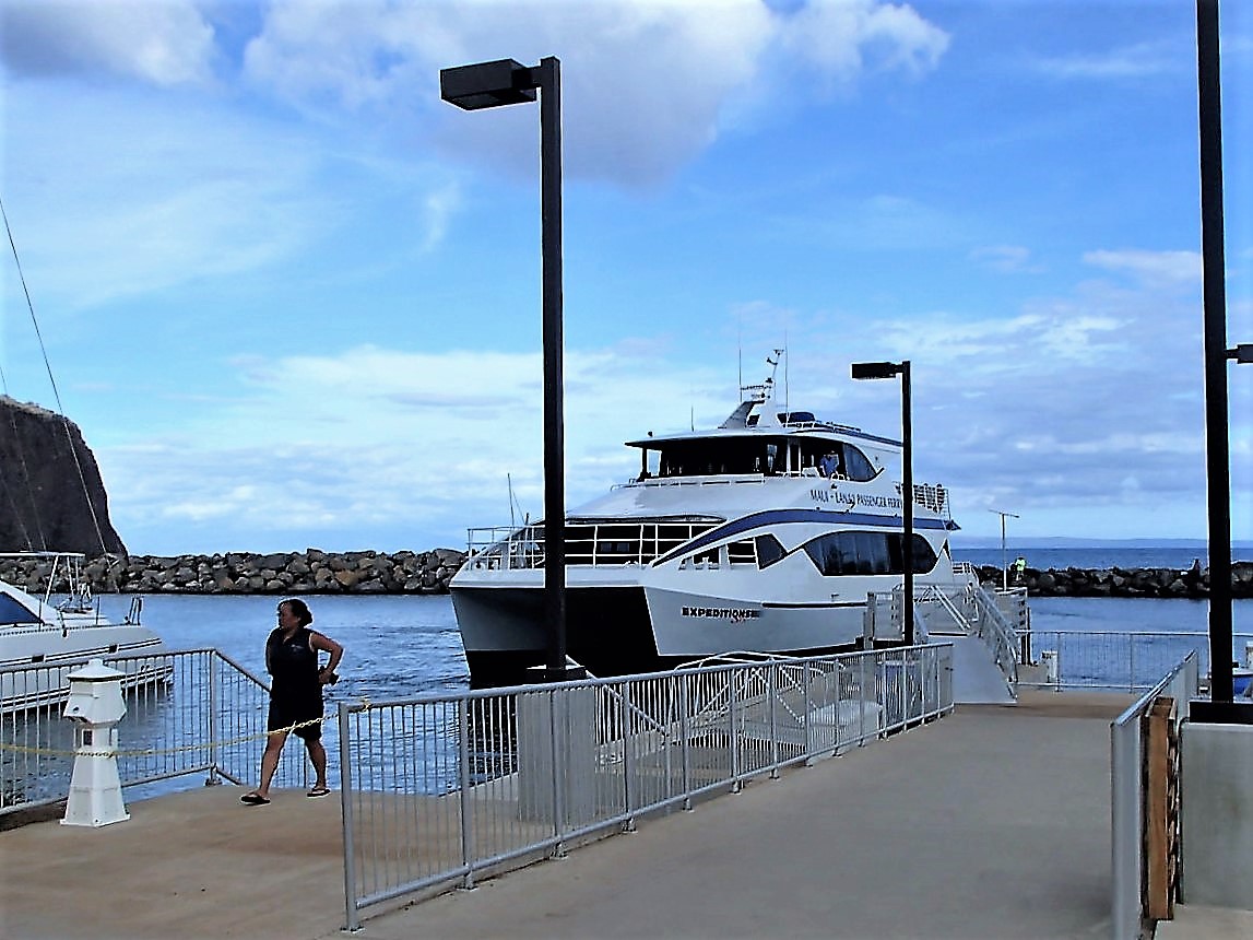
LAHAINA HARBOUR on the MAUI west coast. EXPEDITIONS LAHAINA ferry to LANAI
5 departures/returns per day - see website for times.Cost me $60 return from the pier ticket-office but maybe online bookings cost less. I considered $60 GOOD VALUE in my quest to include another island on my TEZZA'S BEACHES AND ISLANDS list - and subsequently EXCELLENT VALUE considering I judged it my #1 day trip.
Note LANAI in background - a bit of telephoto in this shot.
I was expecting a refurbished old-style ferry (LAHAINA is a refurbished old-style whaling/surfer/hippy town) but what we had here is a modern fast catamaran type craft could do the trip in comfort in around 35minutes (these panorama shots click-expand nicely).
On leaving the harbour was this nice view of surfer-dudes working what is known as HARBOUR REEF (HARBOR fer yu Yanks who spell sensibly)
LANAI in background, maybe a bit small - wide-angel in use.
A bit further out, nice view of MAUI WESTERN HIGHLANDS behind LANAI and....
The KA'ANAPALI hotel strip to the north.
Note calm seas - the straits between the islands are sheltered from the north east trades 95% of days so this is usually a benign crossing.
Day trip snorkeling boats on the approach to NAMELE HARBOUR, no doubt from MAUI - I've read LANAI is a top snorkeling location. I didn't check this area - later had a look at nearby HULOPOE BEACH.
NAMELE HARBOUR
Docked. I've learnt over the years to sit back in my comfy seat and let everyone else "debark". I mean any waiting transport is not gonna take off -why join the slow shuffling lines?
The island shuttle van was waiting outside the pier area to shuttle people to accommodation, the golf course or up to town for $10.
The driver was a font of information on the island geology, geography and history.
Distance to town is about 10mi/16km and takes 20 mins. The initial climb from the coast to the caldera floor (which is approx 1200-1500ft/370-460m above sea level) is winding and scenic. Once on the.....
....CALDERA FLOOR....
....it was reasonably flat but equally interesting.
This used to be sugar cane land, then cattle ranching and finally the world's biggest pineapple plantation. Doesn't look it here but a lot of the journey was thru very DRY looking country - this is a real rain-shadow area. Despite this the soil is very rich volcanic based - the pineapple people solved the low rainfall problem by planting thousands of those COOK ISLAND PINES you can see - dew from the passing moist trade winds condenses on their needles and drips to ground, apparently increasing the height of the water table by a very useful amount.
None of my pix illustrated the above well, so I pinched this one from https://holeinthedonut.com/
LANAI CITY....
....is just a town - as said population is about 2800. Straight line distance from northern-most house in image to southern-most is 1.3mi/2.1km.
DOLE PARK
Town central is DOLE PARK, a nice area of grass and Cook Island Pines. There is no shopping center/CBD as such - the park is surrounded by the island's main institutions like the hospital. police station, Dept of Motor Vehicles, the high/elementary school, several churches and banks, plus a couple of small supermarkets with a larger one just a few blocks away.
Also surrounding the park are several cafe/restaurants, craft shops, realters etc - most in converted houses such as the art gallery above.
This place had some real nice stuff:albeit a bit pricey for this bottom-budget backpacker - best value to me was the volunteer staff member, so bored that he kept me busy for 30 minutes with a huge amount of interesting answers to my questions about the island.
Also in a converted cottage - the LANAI ANNEX of the UNIVERSITY OF HAWAII.
LANAI CULTURAL AND HERITAGE CENTER....
....is in a purpose-built structure across the road from the park. This has picture-boards, models, audio-visual stuf, photos, maps yada on the island's history and economic development. I spent nearly an hour in there - a history/culture nerd could stay a lot longer. Admission free.
One of many displays featuring the cattle ranching days
Ditto the pineapple growing days
The geology section had lotsa stuff including this relief model - my arrows show NAMELE HARBOUR and LANAI CITY.
RESIDENTAL AREAS
I spent the last half hour in town wandering the nearby streets - this is the main road heading north-west out of town. Most side streets were a bit narrower, some much narrower - one lane wide .
Just about every house was EARLY PLANTATION STYLE. Most had been built by the DOLE AGRICULTURAL CORPORATION to house imported workers. For 20s/30s/40s places they were in very good condition - according to my art gallery friend LANAI CITY had been undergoing a REAL ESTATE BOOM because of the high number of mainlanders and people from other Hawaiian islands seeking retirement or holiday homes - once purchased they RENOVATE like crazy, about which the locals say: WE TOO!
Subsequently LANAI has the highest prices for commensurately sized houses of any small town in the USA (although pretty tame compared to my homeland - $US1 million buys a pretty ordinary house in a pretty ordinary Sydney suburb - not that Sydney is a small town).
It was kinda nice to see even the few new places were being built in the original style. This proposed joint was to be on what looked to be a fire-affected lot.
There were not many of these new places but my friend told me heaps of the old joints had been extended - keeping with the original plantation style.
BACK IN THE VAN
Then it was into the van which was returning these people to an early afternoon ferry. I was heading to adjacent HULOPOE BEACH - the driver took a detour and dropped me off.
Interestingly one of the passengers in shot was a MAUI resident thinking of retiring to LANAI - had a bunch of questions for the driver.
HULOPOE BEACH....
....is pretty gorgeous. About 450m/490yds long and plenty wide even at the top of the tide, it has clean sand, clear water offshore and faces south-west, meaning it is a lee shore 95% of the time (when the north-east trades are blowing) and so has smooth conditions - the only time you would get waves and chop is during/after the infrequent storms to the south.
It is on FOUR SEASONS LANAI RESORT land (the resort buildings are in background) but the resort welcomes beach visits from outsiders by providing excellent change sheds and picnic facilities this end of the beach. Cynics will say HAWAII'S strict PUBLIC ACCESS TO ALL BEACHES LAW leaves the resort with no option, but it doesn't have to provide and maintain such excellent facilities.
The only reason I didn't give HULOPOE the BEST RESORT BEACH award on my MAUI'S BEST BEACHES PAGE was because the resort itself is somewhat out of the reach of ordinary holiday makers, unlike KA'ANAPALI on MAUI'S west coast (okay, KA'ANAPALI'S resort prices made this cheapskate traveler's eyes bleed - one reason I was staying in a backpacker dorm back in wonderful LAHAINA).
GOOGLE EARTH IMAGE - beach, resort, harbour. I forgot to add a linear scale - it is 920m/1005yds between the placemarkers of the RESORT and HARBOUR.
There were quite a few people in the water the eastern "public" end of the beach, both locals and what appeared to be a day-trip group from MAUI getting some beach and snorkeling time. I took my face mask out - some okay coral and fishies along the western headland just out of left-frame: the reef extending out into the bay under most of those people. With the benign sea conditions I was not surprised by no rip currents etc.
Those are GOLF COURSE CONDOS on the far headland. Most were built by the resort, but mainland showbiz and IT celebrities have constructed their own holiday homes there. LANAI is very big with this group. BILL GATES got married on the 12th hole. LARRY ELISON of ORACLE bought 98% of the island off THE DOLE CORPORATION and redeveloped the FOUR SEASONS resorts. He has also spent a lot of money on LANAI CITY facilities.
The western end of the beach had sunlounge-umbies set up for FOUR SEASON guests. A benign-slope walking track leads up to the resort - less than 5 minutes. A couple of beach attendants for guests but note - NO LIFEGUARDS (no doubt the beach guys would have rescue/CPR skills - hell I have and I don't work in that industry) although the gentle surf would preclude the necessity. Irregardless - keep a close eye on yer kids: they can get into trouble in the BATH, let alone a small-wave/currentless beach.
FOUR SEASONS RESORT
After the beach I wandered up to the resort which seems to have no restrictions on outsider access. Recently refurbished by LARRY ELISON, it reeked of UNDERSTATED ELEGENCE, whereas most of the hotels back on MAUI did the overstated flashness routine. Costs are mind boggling - check the booking sites: it's hard to get a room at the above joint under $US1000 a night. The beach hotels on MAUI go for $300-500. Strewth, even the latter is more than my WEEKLY teachers' pension.
Part of the cool pool area
I grabbed a beer at the pool-side bar. Interestingly, beverage and food prices seemed not too much higher than main street places back at LAHAINA - and those don't have the outlook or cachet of this place.
Sweet
FOUR SEASONS LANAI RESORT from GOOGLE EARTH. Golf condos to left.
I MISS THE FERRY!!
I gave myself 40 minutes to get back to the 1630 ferry - 10 across the beach and 30 via the coastal "track" which I'd read had some good photo opportunities...
....which was not wrong. The resort/golf course headland from towards the end of the opposite western headland. A little further on....
....the often photographed PHU'U PEHE (SWEETHEART ROCK)
BACK ON THE TRACK (yellow)
Maybe I spent too much time searching for the best camera angle. But my main trouble was I'd last checked Google Earth about a month before - thought the coastal route (yellow) was only a little more than the direct road link (blue) - turned out abt 1500m vs 650m and although starting well deteriorated to bush-bashing the last 500m. I HATE BUSH BASHING on account....
....my old shins are kinda thin-skinned and get knocked about easily by sharp undergrowth.
Consequently the ferry had just left the pier when I finally made it.
No worries, there was a later service at 1845 and my dance-card for back in LAHAINA was empty, so I strolled back to the beach on the direct road route (less than 15 minutes - DUH!), had a beautiful swim/relax and made it back to the pier in plenty of time.
The 1845 arrives.
1930 LAHAINA HARBOUR
"AS THE SUN SINKS SLOWLY IN THE WEST WE BID FAREWELL TO THE LANAI FERRY" to paraphrase JAMES A FITZPATRICK: "TRAVELTALK MOVIE SHORTS" 1929 on.
Actually we are bidding HELLO to mainland MAUI (um ALOHA may seem more fitting but it also means farewell).
Keen-eyed readers might notice we are heading OUT of harbour - because we were doing a short MAN OVERBOARD PRACTICE DRILL: something any safety freaks will appreciate.
So there you have it trendsetters. I urge you to make room for a LANAI visit during your MAUI stay - it looks and feels so different to the bigger island: relaxation personified. HALEAKALA and the ROAD TO HANA might be more the 2 must not misses to gain a good idea of MAUI but I found LANAI even more enjoyable.
----------------------------------------------------------
IF YOU SEE MISTAKES OR HAVE EXTRA INFORMATION PLEASE POST BELOW.
BUT IF YOU HAVE QUESTIONS PLEASE ASK THEM IN THE FORUM SECTION WHICH I CHECK MOST DAYS WHEN NOT TRAVELING - WHEREAS I REVISIT THESE INDIVIDUAL LOCATION PAGES ONLY OCCASIONALLY.
VISITED JULY AND AUGUST 2017
Locals enjoy the Iao Stream
The IAO VALLEY is one of the biggest in MAUI'S WESTERN HIGHLANDS. The highlands are the severely eroded remnants of MAUI'S first volcano - MUANA KAHAHAWAI. Because this is several million years older than MAUI'S other volcano, HALEAKALA. erosion is much more advanced - HALEAKALA is still recognizable as a rounded SHIELD VOLCANO whereas MUANA KAHAHAWAI looks a mess of mountains and valleys. It doesn't hurt that that section of the WESTERN HIGHLANDS has the earth's second-wettest meteorology station.
Oblique Google Maps image - IAO VALLEY.
IAO VALLEY has vast historical significance to Hawaiians and some very pleasant/scenic locations plus very good trekking. As a result it is one of the more visited locations on the island.
The IAO VALLEY gap from KANAHA BEACH adjacent MAUI'S main airport. There is a fair bit of telephoto here - we are abt 8miles/13km from the valley entrance....
....and in the opposite direction, KANAHA BEACH from a few km up the valley. Might be clearer if you click-expand image.
Slope behind arrow is the lower northern foothills of HALEAKALA volcano.
IAO STATE PARK - IAO STATE MONUMENT
This is one of two heavily visited parts of the valley. Besides attractive stream pools, some nice garden areas, viewpoints and trekking opportunities is is also known as IAO STATE MONUMENT - a monument to the 4000 warriors who fell here in a huge inter-island stoush back in 1790. Actually I'm still unsure whether the WHOLE park or just a LIMITED AREA makes up the MONUMENT.
I was lucky - the valley was severely flooded in September 2016 and after extensive repairs this area had been temporarily opened to high season visitors the day of my visit. After high season it closed again to allow further restoration. So check its open status before you go. STATE PARKS has a good website.
SOME IDEA OF THE FLOOD
This house is down valley a few km and somewhat higher than the IAO STREAM which is also some distance away. Houses across the road from which I took this shot had their stone front fences destroyed and I reckon they were another 60ft/20m higher.
THE CAR PARK
The carpark is at the end of IAO VALLEY RD which is the extension of MAIN ST from downtown KAHULUI thru WAILUKU. It's abt 2 miles/3.5km from the valley entrance, only 0.6mi/1km past KEPANIWAI PARK and 5.8mi/9.3km from KAHULUI HARBOUR out of image to right.
Unfortunately public transport does not come up here - the nearest bus stop if for bus#20 in WAILUKU abt a 2.8mi/4.5km walk - shouldn't be too difficult: I managed the reverse on wrecked knees after my big valley ridge hike (okay it was downhill, but anyone with wrecked knees will tell you downhill is harder).
I forgot to add a linear scale - it's 2.6mi/4.2km between the place markers for Car Park and Wailuku (may be clearer if you click-expand).
The carpark is pretty small with abt 50 spaces and was full on this first day of re-opening (that clrar area you can see above closest the river is actually a pedestrian walkway with some nice views down over the stream).
Many people had parked their vehicles alongside IAO VALLEY ROAD and walked in - this avoids** the entrance fee of $5 per car for non-locals.
**at least if they walked behind the toll booth like sneaky me.
Pre-flood Google Earth image of car park and nearby. It's 250yards/230m in a straight line between Upper Viewpoint and Toll place marks
The rebuilt car park area has a new amenities block and possibly the best view in the area of the famous IAO NEEDLE. There was no food available at the time and knowing STATE PARKS' aversion to food trucks etc this is probably permanent.
I didn't see any picnic facilities here, but KEPANIWAI PARK is just down valley and had lots - mind you it is very popular. I also noticed a lot of the native Hawaiian families enjoying the pool areas had picnics laid out on the rocks.
Taking the exit track background-left above you will soon come to....
....THE KINIHAPAI BRIDGE over the tributary of the same name.
This is supposed to be a favourite jumping spot for local kids but on this first day they hadn't yet made it.
For some reason I didn't get a pic of the bridge so I had to pinch this one from WEDENGAGE.COM - but it is totally excellent: the photographer seems to have gone to the effort to get downstream in order to catch the NEEDLE behind the bridge. Can't beat those pros.
Once across the bridge you have a choice of turning DOWN to the left or UP to the right.
If you turn left and head down the side track you access within 30m....
....THE ETHNOBOTANIC LOOP
This is a section of circuitous paths around a garden setting, which as the name suggests, commemorates the various ethnic gardens of HAWAII: Japanese, Korean, mainland settler and particlularly local pre-colonial Hawaiian.
I think this is a PRE-FLOOD pic (once again I had to resort to GOOGLE IMAGES: this one came from the DIVISION OF STATE PARKS) - it wasn't quite as lush when I called by but still a very pleasant place to wander (about 300m of pathway) and sit (no benches but garden border walls did the job).
This area has a bonus - it is the best location to access the....
....IAO STREAM POOLS
Seemed like half the visitors were down there.
The pools looked inviting so after this pic I naturally had to try one. Be careful, rocks can be slippery - note too that flash flooding is not unusual during/after rainstorms.
THE NANNY STATE STRIKES AGAIN
One problem with access to the pool areas and hiking tracks was the proliferation of NO ACCESS signs. Maybe this is because authorities want to do more stabilisation work - however I noticed these signs are very common in other STATE PARKS and NATIONAL PARKS areas.
No worries - so many locals were ignoring the signs that I thought even the most officious ranger would not try to book them - and being a great fan of mass civil-disobedience I joined the mob.
STAIRWAY TO HEAVEN?
Well not quite.
By t
urning right of the bridge you immediately hit a set of stairs which go about 300m up to the IAO NEEDLE viewing platform (Upper Viewpoint on Google Image).
Pic again from WEDENGAGE.COM. There are 130 or so stairs, fairly steep but the trip is relatively short and there are opportunities to stop and rest including....
....AN INTERMEDIATE VIEWING PLATFORM
The outlook down valley is not bad here, as is....
....the view of the NEEDLE.
THE UPPER VIEWING PLATFORM
This is the end of the road for most people. As seen the view of the NEEDLE is good but down-valley is a bit restricted from here. There is also a bunch of information panels on the area's geology, flora and human history.
My pics of this area were way inferior to this great shot also from WEDENGAGE.COM.
MORE NANNY STATE
 I was itching for a nice long trek in the bush. I'd read how native Hawaiians back in the day used to climb the NEEDLE to spot incoming sea traffic and I was wondering how close I could get. It was obvious that a trail left from the UPPER PLATFORM but it was blocked by a railing and the usual sign.
No worries - I figured it unlikely any rangers would be on the trail (my observation in other places is that it takes a hell of a lot to get them off their bums and out of admission booths and admin offices) and so I jumped the fence and took off up the......
....KINIHAPAI-IAO RIDGE TRAIL
That's MY name by the way - because it runs up the high ridge between the IAO STREAM and the major KINIHAPAI tributary.
I was itching for a nice long trek in the bush. I'd read how native Hawaiians back in the day used to climb the NEEDLE to spot incoming sea traffic and I was wondering how close I could get. It was obvious that a trail left from the UPPER PLATFORM but it was blocked by a railing and the usual sign.
No worries - I figured it unlikely any rangers would be on the trail (my observation in other places is that it takes a hell of a lot to get them off their bums and out of admission booths and admin offices) and so I jumped the fence and took off up the......
....KINIHAPAI-IAO RIDGE TRAIL
That's MY name by the way - because it runs up the high ridge between the IAO STREAM and the major KINIHAPAI tributary.
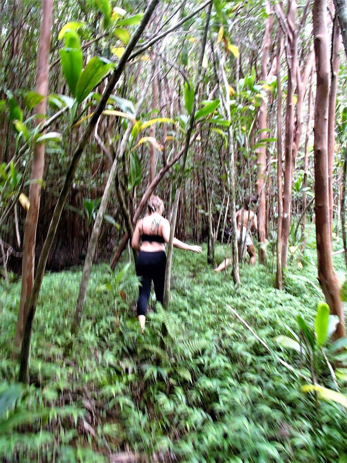
Conditions varied on this track. Gradient was pretty good, from mild to moderately steep but never really difficult. Few steps. The track surface was sometimes good, other times rough with plenty of roots and rocks. Good footwear recommended. I was surprised by relatively little mud for one of the wettest places anywhere. Then again it hadn't rained for several days 4km away down in WAILUKU.
After 40 minutes I met up with 2 local girls and a guy - they seemed to know what they were doing (although the girls had bare feet!) so I tagged along.
This is the closest I got to the NEEDLE - it's actually across the other side of the KINIHAPAI STREAM from the ridge I was on. My new friends told me you can access the base by rock-hopping up the stream but would need ROCK-CLIMBING/BUSH-BASHING SKILLS to go up the NEEDLE. No thanks - we pushed on.
Some nice views of the valley edges up here. These panorama shots click-expand nicely.
WHEN THE GOING GETS TOUGH....
....THE TOUGH TURN BACK.
Progressively the track got rougher and narrower - several times we had to bush-bash and more than once lost the track. Sometimes surrounding cloud misted-out visibility. Finally 90 minutes from the start we decided to give up and head back - we figured we were half way to LAHAINA on the west coast at that stage.
BACK NEAR THE TRAIL HEAD
We made slightly better time on the return trip, reaching the start just under 3 hours after leaving it. We passed 5 other hikers over this time.
OH GEES, DID THAT BLITZ MY KNEES!
Actually this shot shows blitzed shins - the result of bush-bashing thru sharp undergrowth without long duds.
But my 72 y.o. knees were in worse shape - already dodgy from too much jogging in bad/no shoes back in the day and exacerbated by an earlier 6+ hour CRATER HIKE ON HALEAKALA, a 3+ hour WAIHEE RIDGE TREK, several shorter hikes to waterfalls on the HANA ROAD and to several isolated beaches , not to mention a 40km cross-island bicycle ride; they were pretty sad after the IAO VALLEY gallop. And they're still not great at the time of writing 2 months later - maybe the 30+km of walking on MAUI'S west coast the following week wasn't such a good idea.
KINIHAPAI-IAO RIDGE TRAIL.
Purple - top viewpoint Orange - Oaho Needle White - turn-back (approx). White point on far right margin is car-park. Click-expand much clearer.
Ignore Yellow - MISTAKE, but this new version of Google Earth is difficult to correct (at least for this IT-challenged 72yo).
Update - well that was when I first downloaded GE - it now is back to normal allowing me to do the other "maps" on this page normally - but I can't be bothered redoing this one.
WOULDN'T YOU RATHER DRINK COLD BEER ON THIS UPSTAIRS VERANDA....
....THAN WATCH NAKED HIPPY-CHICKS AND TOURISTS DANCE TO THE BEAT OF A BONGO?
My new friends were heading to the Sunday afternoon DRUM CIRCLE at Makena's LITTLE BEACH and asked if I'd like to tag along. But having been a nudist since my teens I'm a bit rlaxed about naked chicks, hippy or otherwise, and I knew there was a bunch of ice cool beers waiting for me back at my WAILUKU hostel. So I declined. Should have got a lift with them the 4km down there - walking hard surfaces downhill (although moderate slopes) is not great for already wrecked knees.
KEPANIWAI PARK
Only 600 yards/1km down the road is IAO VALLEY'S other visitor attraction - actually it seemed more popular than the STATE MONUMENT area. Maybe that's because the garden area is bigger, there are picnic facilities, heritage buildings, an associated NATURE CENTER, parking is probably better, entrance is free and being a COUNTY park vs STATE park, it was repaired of flood damage and reopened earlier - and didn't seem to have those annoying NO ENTRY signs.
The park is mulitfunctional....
....Set up as a HERITAGE GARDEN AREA, it has displays of gardens and housing representing MAUI'S multicultural past. There is stuff representing JAPANESE, FILIPINO, KOREAN, native HAWAIIAN and AMERICAN MISSIONARY history (pic MAUI ALOHA WEDDINGS)
More heritage stuff (another M A H pic - I called in here as an addendum to BANANA BUNGALOW hostel's free WAIHEE RIDGE TREK and had less than an hour which I mainly spent checking the river area, not taking lotsa pics which is surprisingly time-consuming).
Replica of early cane workers' housing - probably from Japan by the looks of the pond - most imported cane workers were from either Japan or the Philippines (another M A H pic)
Early native-Hawaiian meeting hall (pic from Gardenvisit.com)
....away from the heritage area is plenty of PICNIC FACILITIES with big pavilions not unlike above but with seats and tables and adjoining bbq facilities (but I didn't see any hot food vendors) - also limited picnic tables down near the stream.....
THE STREAM HAS MANY POOLS TO DIP A TOE, PADDLE OR TAKE A DIP....
....which once again were proving a hit with locals (this was a weekday but a couple dozen families were down there)
PARKING AND SCENERY
KEPANIWAI PARK can't match the mountain scenery of the MONUMENT AREA up the road, but views of the surrounding area were not too shabby. That's NOT the IAO NEEDLE - it's further up valley.
PARKING was a bit tricky - our van driver had to search around some time for a space even on a week day. There is a smallish overflow lot across the main road from the lower entrance but when I walked by after visiting the MONUMENT AREA on a Sunday it was packed. Once again plenty of people parking roadside. Mind you, the park appeared even more crowded than mid-week maybe because I could hear a good rock band - hey maybe M A W had a shindig going.
HAWAII NATURE CENTER
This compact area adjoins the park. There is a museum with interactive displays, more loop paths thru garden areas, organised hiking programs and educational stuff for kids. Admission is free but I only had time to stick my head in the door of the museum.
This is one area I intend to spend more time at when I return to MAUI - as a matter of fact the whole IAO VALLEY area demands another visit.
Museum (pic from koddler)
Looks good to me (pic MUAI LEISURE GUIDE )
Entrance to the park is 2mi/3.2km along Iao Valley Rd from intersection of Main St and High St Wailuku to right of image.
ATTENTION: IF YOU SEE MISTAKES OR HAVE EXTRA INFORMATION, PLEASE POST BELOW. BUT IF YOU HAVE A QUESTION, PLEASE ASK IT IN THE FORUM WHICH I CHECK MOST DAYS - I REVISIT THESE INDIVIDUAL PLACE PAGES INFREQUENTLY.