Dad and daughter prepare to check the fish-feeding frenzy at Turtle Bay - Perhentian Besar.
Long the backpackers' haven, the Perhentians are now becoming a must-do for a fuller range of travellers. Makes sense - the attractions are user-wide: everyone is looking for white sand beaches, clear water, good snorkelling and nice scenery. And problems of the past like higher than normal crime seem to have been eradicated by some heavy policing - and in July 2011 the usual high season overcrowding was not apparent. Recession in the northern hemisphere may not be all bad.
LOCATION
 One of a number of attractive island sites in far north-east peninsula Malaysia. Kota Bharu is the nearest airport although Kuala Terengganu is a good one to fly out of if you also visit Pulau Redang and Pulau Kapas after the Perhentians. Pulau Lang Tengah is another good one to visit along the way - it is the small island between the Perhentians and Redang. Kuala Besut is the main mainland pier for the Perhentians. Scale - it's 150km from the Kota Bharu placemark to the Puala Kapas placemark.
MAP
 One of the best comes from the efficient De Penarik Beach Travel & Tour booking website. Looks like they got help from the Marine Park Department.
WHICH ISLAND?
The BIG ISLAND (Besar) has:
- better snorkelling off the beach
- more higher range accommodation
- arguably the best beach
- camping sites
The SMALL ISLAND (Kecil) has:
- a better travellers' scene
-more budget accommodation
- better trekking
- more chances to get away from the busy scene
But the islands are so close it's easy to choose a resort on either and jump across to the other to check the scene - water taxi price between the Long Beach on Kecil and the pier at Perhentian Island Resort was only rm10 in July 2011.
Alternatively, why not do as I did in my 1999, 2011 and 2013 visits and split your stay between resorts on both islands? You are moving to a new island and resort, but it only takes 5 minutes and minimal expense.
PERHENTIAN BESAR.

BESAR BEACHES

The southern west coast beaches

(from the south)
 The southern most beach has no resorts. Snorkelling seemed popular both off the beach and from boats at the far end.
 Taken from the same rocks as the previous shot, Teluk beach is next one north. This is where the steep jungle track from the south coast's busier Flora Bay hits the east coast. Teluk is the site of the Teluk Ke Ke camp site.

 Abdul's beach is separated from Teluk by stairs and a short walkway. A longish pier from which this shot was taken halves the beach with Abdul's situated on this southern section. The pier did not exist on my '99 visit and has detracted from the beach's appeal, but this is still a pretty nice area. Okay snorkelling around those patches of coral in shot but not comparable to the other side of the pier. Actually I'm pretty sure Abdul's has moved location and was at the north end of the combined beach in '99. Abdul's is a lot flasher too - but still has some budget bungalows along with a big bunch of flashpacker standard places.

 Tuna Bay. Same beach north of Abdul's pier - it actually curves around the far corner for another 100m or so: the beach is still good and the snorkelling is some of the better stuff I have seen off the beach in Malaysia or Thailand in the last few years with some pretty good coral varieties and fishies. No shortage of piscines hanging around the pier either. Some nice resorts along here - check De Panarak's map up page. Tuna Bay resort is the most highly rated Besar accommodation on Trip Adviser at the time of writing. At the far end it becomes difficult to continue moving northwards - the 250m walk-way I used in '99 over an extended rocky section seems to have fallen or been swallowed by the jungle. I think at low tide you could wade around the rocks but the tides did not suit my visit this time. UPDATE 2013 - I found a jungle track along the water pipeline which goes across to Mama's beach to the north. More details in the TREKKING SECTION.

The northern west coast beaches

 Mama's beach is immediately past the difficult to pass rock section morth of Tuna Bay and is the poorest on the island - non existent at high tide but given to untidy tidal flats with broken coral and sharpish rocks when the water goes out. No matter, the best beach on the island at Perhentian Island Resort is a little over 10 minutes walk away. I stayed at Mama's in '99, not thru choice but because it was the only place I could get into in those crowded days with fewer resorts and difficult forward booking. Not a bad place. UPDATE - I had a few meals here in 2013. Pretty good budget food and the place still seems popular.
 Mama's skinny beach widens about 100m north into what I call Coral Resort's western beach. In fact it looks a lot nicer here than reality - mainly because it has the same low tide blues as Mama's. In '99 that small creek crossing the beach mid-way along (click to expand shot) was dire with pollution. It was considerably improved in 2011 and virtually non-existent in 2013.
Coral Resort has a second beach around the other side of that far headland - seen in the next shot...

 ...Coral Resort's northern beach taken from the Perhentian Island Resort pier - the sand is a bit coarse with broken coral and it also suffers the low tide blues, but overall not a bad little beach. If you are not happy, the best beach on the island is less than 5 minutes up those stairs to the left.
In the lowest quarter of the tide it is fairly difficult to enter the water on account of lots of broken coral underfoot but there is a sandy patch to right of camera where the dive shop parks its boat. I found snorkeling pretty ordinary coral-wise to right of camera and behind towards the Perhentian Island Resort pier, but it was not bad around and past that offshore rock background far right.
I made this resort my first stop this trip, will try to get a trip report done soon.
 Best beach on the island - in front of the Perhentian Island Resort. This is shot from the walkway between Coral Resort and PIR. If you click to expand you can better see the walkway bottom right and part of this bay's pier bottom left. Because the pier is at the end of the bay it does not detract from the appearance as much as say Abdul's.
 Another shot of the beach at PIR. Lovely fine sand, very clear water deep enough at all tides except against the far headland. Note this beach is not exclusive to the resort. You can easily access as far away as Mama's, add a 10 minute jungle trip from the north end of Tuna Bay/Abdul's beach and several guests from my Flora Bay (south island) resort in 2011 took the 25 minute jungle track to spend time on this beach. The best way to access from the more distant locations would be by water taxi - plenty come over from the other island.
 North coast beach
 Turtle Beach is the only west coast Besar beach you cannot access on foot. But it is popular with beach fans who get a water taxi to drop them off for a few hours. Similar sand and water to PIR and some okay snorkelling off the rocks to the north-west - better close to the rocks than out where the snorkelling-trip boats park.
South coast beaches.
 Flora Bay is the longest beach on the island. Unfortunately it suffers quite badly its full length from the low tide blues with very shallow water a long way from the beach at low tide. The falling tide exposes large expanses of mostly sand flats but broken rocks appear some distance behind camera past Arwana Resort's pier. Pretty appealing nevertheless back in '99, it now has perhaps a few too many resorts.
Snorkelling off the beach is very ordinary but Shark Point is at the far end of that distant headland - a 350m swim from the beach (don't ask me how I know) is a very popular spot with the daytrip snorkelling boats because of pretty good coral, fish including some bigger ones and plenty of harmless reef sharks.
 Bubble's Beach on its own little bay on the eastern side of the south coast is another that can only be reached by water taxi - unless you are staying at Bubble's Dive Resort, a rather attractive flash-packer/lower mid range joint behind the trees at the far end of the beach - which was one of the few resorts I saw in 2011 which looked to be running near capacity. This is a pretty good beach with nice sand although not as fine as say PIR's, clear water, deep enough water at low tide and pretty good snorkelling off the beach. Some effective shade from beachside trees most of the day.
TREKKING ON BESAR
If you check the first Google Earth image on the page or the maps below you will see that it is possible to do a circumnavigation of all settled parts of Besar excluding Bubbles by combining jungle tracks with beach walks. The total would take 2 hours or so - if you are not that keen, the smaller sections join some pretty attractive places.
Flora Bay to Perhentian Island Resort/Mama's

This is a reasonably easy walk with only a few steepish slopes and can be done in flip-flops or other light footwear although better shoes are always a good idea. This track in '99 used to leave about mid-beach at Flora Bay but now there is a much clearer and signposted entrance on the western side of Arwana Resort a bit inland from the litttle mosque. The first 10 minutes behind the beach is a trifle hot but once you hit the jungle area there is plenty of shade. After another 10 minutes of mostly not too steep climbing over a low saddle you reach a downgrade where the track splits - for PIR's lovely beach (5 minutes) take the right branch which dives downhill to some squarish metal water towers and then past some of PIR's cheaper A-frame hillside bungalows to emerge beachside near the pier.
To get to Mama's take the left branch which then loops left slightly uphill and continues past the back of Coral View Resort to descend to the rear of the very last huts on the southern end of Mama's - 10 minutes from the junction. By the condition of the track, few people use this section - it is much nicer taking the coastal route between PIR and Mama's.
 This is about the roughest section of the track to Mama's - I think it was put in as an access track for the water pipelines which run between an artesian water plant behind Flora Bay beach and Perhentian Kecil village (it looks like the pipeline goes along the seabed between the two islands).
Mama's to Cocohut/Tuna Bay

In '99 there was a concrete and timber walkway between the 2 beaches but this had been swallowed by he jungle by 2011 - however I figured the locals would want to move between these areas without the expense of a water taxi and went looking for a pathway in 2013....


Cocohut looks a pretty nice flashpacker level resort for those who don't mind a bit of a climb from the beach.
Flora Bay to the southern eastern beaches
Go to the far western end of Flora bay and look for the concrete path which runs from there to the water plant behind a lot of the Bay's accommodation. About 50m from the beach end of the concrete you will see a sign JUNGLE TREKKING to the left.
This is a real tough one - super steep for 10 minutes on each side and with lots of rocks and tree roots which make flimsy footwear a no-no. Very good jungle though. Near the Teluk Beach the track splits but any one of about 4 branches will get you to the sand. This track is a good workout but the beaches at each end are well worth it.

2013 improvement when going in the opposite direction:the departure from the western Teluk side is much clearer now - this is towards the southern end of the beach.
ARWANA RESORT
This is a midrange place at the far eastern end of Flora Bay. I decided to stay here because it also has a dorm - the combination of a dorm, a fabulous pool and a nice comfy lobby with lots of chairs and fans where you can sit around into the night and read etc is pretty appealing after several weeks of backpacking. The fact that it could be pre-paid in aussie dollars on Agoda added to the appeal.
Arwana has Eco Resort in its full title but I could see very little eco about the place - no solar panels, wind turbines or even recycling bins. One poster about preserving soft corals. Unlike a lot of Perhentian accommodation you can buy a beer here. Not sure about wine/spirits/cocktails.
 Arwana from its pier. Note the beach here is not great - virtually non-existent at high tide yet the boat left of shot was sitting on sand at lowest tide. However the sand widens at high tide about 70m to left of camera, although the low-tide blues still prevailed. Big pool behind lobby/restaurant area in shot is surrounded by 3 storey modern blocks of rooms and there are some rather nice beachfront chalets to left of camera. Dorm area is to the far right behind other accommodation.
Food by way of buffets - most guests are on packages. I wasn't but still found the 18rm brekky pretty good value (egg tragics note, no egg station). I can hoover enough down at a buffet brekky to make lunch superfluous. A couple of very good value beach restaurants within 150m to left of camera for other meals which at Arwana were less value than brekky - more like 35rm.
 Part of Awana's lovely pool. Nice water fall to right, pool big enough to make lap-swimming a non-tedious way of burning off buffet calories. Sun lounges neat for swanking it out with a bottle of duty free whisky from Singapore's great budget terminal while checking out the mid-range heart-breakers. Such ladies don't suffer the Macca's/Krispy Kreme lateral expansion to the extent of post Y2000 backpacker babes.
 The dorm area is in a shady area between Arwana's eastern most modern wing and the eastern headland of Flora Bay. I think this may have been put in to attract divers to the dive school, but I found I was the only western guest and they gave me a 2 double bunk room all to myself. Lots of locals in other rooms but as far as I could work out, nearly all seemed to be staff.
My room big, clean, comfy, quiet - my only complaint was the outside bathroom needed a good clean-up which I asked for twice to no avail.
Value? Well my $aud18/rm55 a night could have gotten me a reasonable fan chalet at nearby budget joints - but they didn't have the great pool or comfy lobby. And by this stage of the trip I'd stayed at plenty of budget chalets. Viva la change.
BEER ON BESAR
For some years between my first 2 visits it was hard to get a beer in the Perhentians, but a change to a less fundamentalist regional government has eased the situation somewhat. In the southern western beaches area Tuna Bay has beer. If you are staying at the northern end of the western beaches you will find a beer at Reef Resort and Perhentian Islands Resort. At Flora Bay Arwana had beer in a separate area and at least one of the beach restaurants close to the west could do the job. I didn't look further. Bubbles with English owners probably has beer but I forgot to check. Note booze aint cheap - 2013 prices were between rm12/14 for a 330ml can. I hate beer in cans!
PERHENTIAN KECIL.
Interestingly the small island isn't that much smaller than the big one. As a matter of fact, if lengthy trekking is your thing this island is much better. Fewer beaches to choose from - but there are some nice ones, including a few great get-away-from-it choices.

KECIL BEACHES

East coast beaches
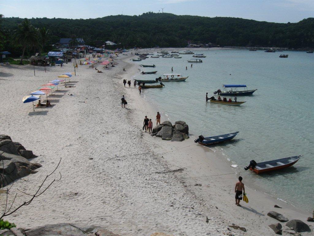 Kecil's famous Long Beach. Old Perhentian hands will bemoan the development - if you click the shot to expand you will see the 2 storey concrete constructions mid beach and the mega pier at the far northern end. Those beach umbrellas/mats are a bit European too - but really there is not too much shade at this beach and at rm10/day - rm2/hour they are not bad value. Anyway there is still plenty of bare sand to lay a towel or sarong. Note the relative lack of people at 2pm on a fine day at the very end of June.
I think the Malaysians could take a hint from busy Thai island beaches and organise their boats into dedicated and more compact buoyed-off areas.
Note the wind-turbines high on the hill in the background - the path to D'Lagoon goes past these.
 This is the section of coast behind camera in the previous shot - ie just south of Long Beach. I noticed on my 1999 visit that at low tide this area developed into a series of small sandy coves for a good 400m - ideal for sunning. The tides were wrong to show these on my latest visits - but this area was quite popular with snorkellers above quarter tide - there is some coral starting someway off the rocks and plenty of fish in the sandy area.
  I thought the northern end of Long Beach was far more attractive - nicer cleaner sand, fewer boats/people/umbrellas - although the water was shallower off the beach as the tide dropped. A real good old time beach bar restaurant, The Pit Stop, at left of image.
 Dave Elliot sent this fabulous shot of Long Beach back in 1994. You can see why some old-timers get so upset about development. My 1999 visit saw the beach more developed, but closer to this shot than my 2011 pic 3 up-page.
 D'Lagoon has the only other east coast Kecil beach (well, the village has a beach but it isn't too touristy). D'Lagoon is way up the northern end of the island. The bay in front used to have really good snorkelling but had sadly deteriorated this last visit - the best stuff was close to the rocks immediately right of camera. Beach doesn't suffer too much from low tide problems and has sand out into the water at such times. Note there are 2 usually deserted east coast beaches, Turtle (10 minutes walk) and Adam and Eve (20m) accessed from D'Lagoon - great for sunsets or just some seclusion. D'Lagoon's biggest negative for some will be its isolation - a pretty strenuous 1 hour+ trek from Long Beach or a water taxi each excursion.
 D'Lagoon Resort seemed to have the highest concentration of budget travellers of all the accommodation I saw. This is shot from the restaurant behind beach - a pretty relaxed place to hang out. Note that apart from budget and flashpacker chalets D'Lagoon also has a dorm.


I called by both new constructions when walking the village-Long beach route - no indication of proposed names.
West coast beaches
Northern west coast beaches

from the north
 Kecil's Turtle Beach - a very short flatish jungle track walk from D'Lagoon on the adjacent west coast. If you click shot to expand you can better see a fair bit of rock and broken coral on the beach, the shallowness of the water off-shore in this mid-tide pic, and how clear the water is. Killer sunsets.
 Next south is Adam and Eve Beach - longer, better sand which extends into the water and deeper water off the beach. This is reached by a signposted short side-track off the main trekking track between the wind generators (sign post after about 20 minutes) and D'Lagoon (15min) - don't be tempted to take the two unposted side-tracks closer to D'Lagoon if coming from that end.

Mid west coast beaches.

 Midway down the east coast, Coral Bay is Perhentian Kecil's second most popular beach. Pretty nice sand, clear water and a big range of accommodation - extending to the rocks in far background and behind camera (this is shot from Senja Bay Resort's restaurant which is at the southern end of the beach).
Biggest negative is the low tide blues - it gets pretty shallow a fair way from the beach at low tide. However no unattractive rocks or mud flats are exposed.
Snorkelling in 2011 was not mind blowing - there were some interesting patches of coral in the buoyed-off swimming enclosure a fair way off the beach to left of camera but a lot of dead and broken stuff closer in. Plenty of fish to keep piscene fans happy.
 Coral Bay and Long Beach are quite close - connected by this well paved 10 minute path with moderate slopes (it was a much more interesting jungle track in 1999). Building activity at each beach end had made the start/end a bit confusing, but look for signs at the far northern end of Coral Bay near the pier and near the southern end of Long Beach. Taking just about any track inland at the latter will get you onto this path. UPDATE 2013 - a lot clearer now.
Note you still need a torch at night.
Inevitably building has started to extend itself along this track and being off-beach there are some nice bargains for newish places. One joint, Tropicana towards the top of the saddle had dorm rooms for rm15 (that's about $us5) and pretty nice individual fan rooms at rm40 (late June 2011). Next visit I wouldn't be surprised to find accommodation and restaurants the full length of this path. (2013 - nope, the biggest change is near the beach as seen below.....)

Note that immediately behind camera is....


The beaches themselves are nothing to get excited about besides seclusion. I snorkelled and found coral very ordinary. The fish scene was not bad and should keep non-hardline snorkellers happy.
I made Shari La my third stop on the 2013 Perhentians visit - will try to talk Lady Tezza into including it in her trip report.
Southern west coast beaches

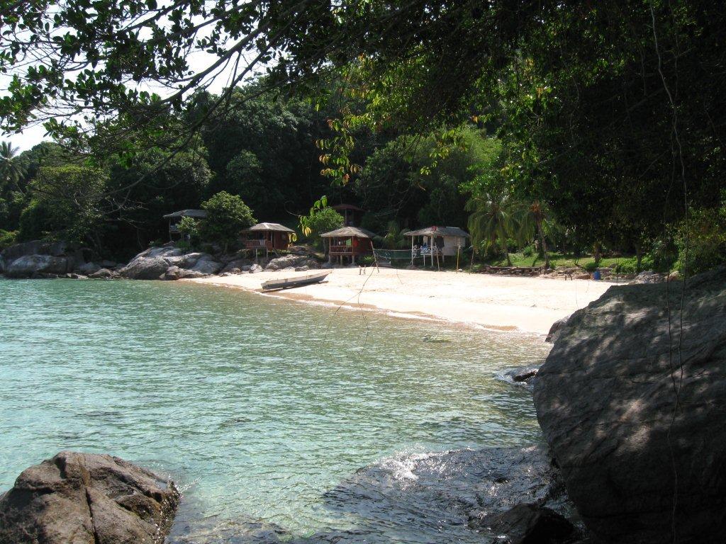 Mira Bay is 25 minutes south of Coral Bay along the surprising good coastal walking track. This place is very appealing - nice sand which extends quite a distance into the water, no apparent low tide blues and one budget resort - click to expand to see some of their chalets more clearly. I'm penciling this one in next visit - it is less isolated than D'Lagoon with Coral Bay and Long Beach restaurants and bars an easy 25 and 35 minute shaded jungle-by-the-sea walk away. Note about one third of the beach is hidden by the rock/headland on the right of shot - but this is still a compact beach.
 2013 - well I didn't stay here latest trip, but called by again. Looked to have the biggest concentration of traveller-types of all the places I visited on both islands (although the closest I got to D'Lagoon, another popular travellers' haunt, was offshore on the arrival speedboat when we dropped some guests off).
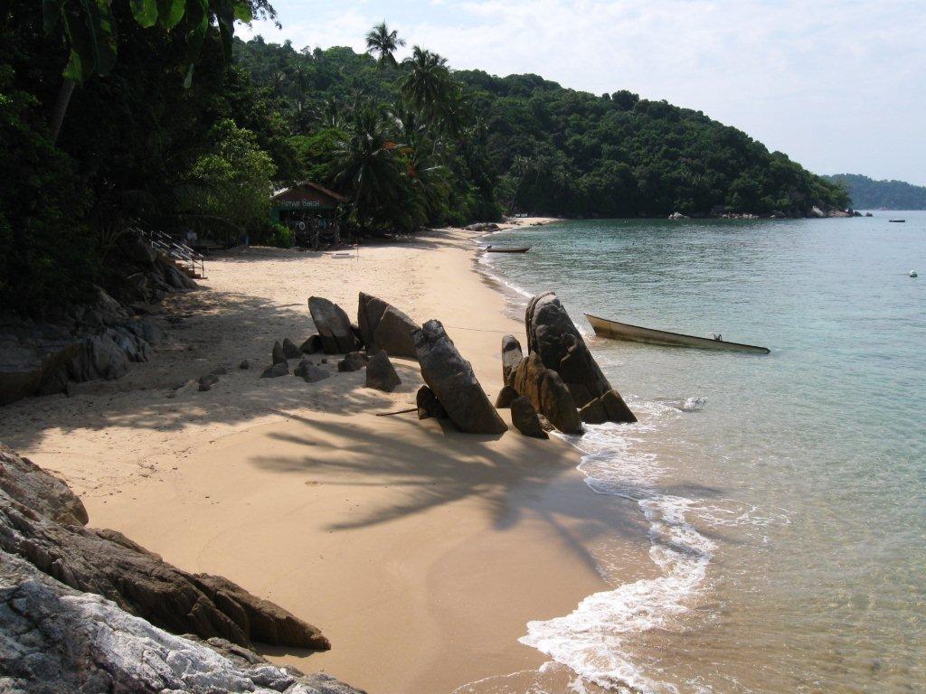 Petani/Impiani Beach is another 10 minutes further south along the track. Technically this is not east coast but on Kecil's south coast. It may well be the nicest beach on Kecil - quite long (those rocks on the sand in far background are actually only a little past mid-beach, and divide Petani beach from Impiani) - lovely water and no low-tide problems, sand maybe not as white as some but real clean and going a long way out into the water before rocks/coral take over.
Arguably you are more isolated from the action of Coral and Long Beaches, but the coastal track continutes 10-15 minutes to the village where there are plenty of shops and restaurants, and this beach is getting pretty close to the south-east and southern beaches of Besar for not too expensive taxi boat trips. Petani Beach resort close to camera is budget/flashpacker standard - the new Impiani (see below) when it opens seems destined to be more upmarket.
 All the old bungalows at Impiani had been pulled down and these rather nice looking jobs seemed about 70% complete. Big race for high season completion probably - this was shot in the last days of June which suggests they are a bit behind.
TREKKING ON KECIL
Walkers on the small island can get a real good workout - a lot of it thru pretty attractive jungle areas.
The Northern Track

This leaves the Long Beach-Coral Beach track pretty close to Long Beach (look for the electricity lines to the wind generators). You can also access from behind some of the beach resorts if you know where to look. The first half hour is mainly a steady climb up to the generators - a narrow jungle path in some areas, a heavily eroded vehicle track in others and a better surfaced vehicle track towards the top. Slopes are mainly moderate but there are a few short steep pinches.
 The wind turbines, sadly not in operation the whole time I was on the Perhentians despite nice wind. However the compound also has a big area of solar panels (foreground) and judging by the hum from the nearby transformers, they were working well.
Note the track to D'Lagoon continues along the fence behind camera (this was taken from the northern end of the solar farm) from where it starts dropping very steeply down a vehicle road. There is also a very nice observation platform of which you can just see part at left of shot - this has good views of the north of the island but sadly not to the south. There is a fantastic stairway which runs from this platform way down to the sea on the upper left coast - don't be tempted to take this as a short-cut to D'Lagoon. See next pix for detail.
After 10 minutes walk down the very steep road you will see a D'Lagoon signposted track leading into the jungle to the right - this winds and drops (no super steep slopes) for another 30 minutes to the resort.
 Pretty impressive set of steps from wind turbines to sea on western side. Click to see observation platform up near wind generators and how sea end of the pier has fallen victim to monsoon season sea wave attack.
 Go down these steps by all means if you fancy a swim in crystal clear water as one couple were doing when I visited, but don't think like me that it looks only a 15 minute rock-hop across to D'Lagoon behind camera. I don't know why I do this - as a former point-break surfer, I hate rock-hopping.
 The trouble with rock-hopping is that unseen transverse gutters from the sea can cause you to climb up/inland - which happened twice along this route. I started the rock-hop off the first flat section of walkway from the water way down there - notice I am now up a fair bit closer to top of stair level. If this wasn't a good enough work-out, I then came to a patch of inpenetrable jungle undergrowth at the top of the second gutter - if there is one thing I hate more than rock-hopping it's bush-bashing - trip roots, thorns, red ants pouring down my shirt etc. Anyway, what looked like 15 minutes turned into a 90 minute saga.
The South-West Coastal Track

This runs all the way from Coral Bay around to the village in the south-east of the island. Maybe an hour in total for a good walker. It is a real nice jaunt - shaded by jungle most of the way but with the sea adjacent and some nice beaches along the way, very good surface, handrails on the few sections of stairs, surprisingly flat for the first section to Mira Beach, not too much worse from there to Petani/Impiani beach, a few steeper but not heartbreaking sections the next 10-15 minutes to the village.
To get to the start, push past the chalets on the rocks immediately south of Coral Bay's beach.
 Part of the south-west track. Note water pipeline which runs all the way from a well just behind Turtle Beach in the far north-west of Kecil to the village in the far south-east.

Village to Long Beach Track
I wasn't aware of this (De Panarik's and guide books' maps don't show it) but my taxi boat driver from the village to Long Beach pointed out an exposed new section thru the trees close to the village which looked very similar to the south-east track.
However this does not make it right thru yet - I went looking at the Long Beach end and all I could find was a small, very rough and steep track along the power lines heading towards the village from where they cross the Coral Bay-Long Beach track. I gave up after 10 minutes - I had done the two other Kecil tracks just before and was in no mood to go slogging up some steep rough jungle path.
A local business owner said yes, you could get all the way to the village, the new track will extend itself along this this way but at the time of my visit (late June 2011) a recent land-slip had made progress along the narrow track additionally difficult.
UPDATE LATE JULY 2011 - mudshark82 who is currently in the Perhentians sent me this info about the village to Long Beach trek: There are certainly some rough parts to trek but there is a big blue pipeline running through the jungle, I followed that for a bit as it had a rough footpath alongside it. Then I got to a point with a tough uphill climb where several trees had been cut down. At this point I was slightly concerned that if I had to go back the way I came I wouldn't make it down on my feet.
Once I reached the top of the clearing I followed a path made by a truck or construction vehicle, my guess, at least 2 years ago. Although tricky at parts this eventually led me to The rear of Rock Garden (?).
think this trek would be much more difficult going the opposite way, but not impossible. There are a handful of points where I had options of different routes I could take and I went with what looked best.
This is one for the adventurer!
Update 2013 - I figured maybe the path had to be finished so I tried again, this time from the village end. I had to make my way past the two new construction sites north of the village......


....from where a very similar paved path to the south-west track (looked about the same age) headed north thru the rainforest very close to the coastal rocks, following the power lines. This was a nice easy walk but after about 10 minutes IT JUST STOPPED. Looks like the dudes ran out of money....

....but I found a reasonable bush track heading north....

So I headed down to the rock platform (there was a poorly defined route heading down, looked like some people had headed that way). Not a good idea - it was reasonably easy going for about 10 minutes, but then I hit a series of gutters cutting into the platform which made me climb way up the seaside rocks and in a few cases into the rainforest for some of my hated bush bashing. After about 50 minutes of that I could see Long Beach but it was still a good 700m away with a few more gutters between. Time to give that the big miss.....

So as soon as I saw the power lines higher in the jungle again, I crossed over and followed the rough walking track alongside. This dropped and climbed, at one stage running beside Rock Garden bungalows which is the southern-most resort at Long Beach (although considerably south and higher than the sand). Finally after climbing more than dropping the power line track came out at the cross island path between Long Beach and Coral Bay, about 300m in from the former.
Time-wise the exercise was a joke - it had taken me about 80 minutes to walk from Coral Bay down the west coast around to the village and then north to where the east coast walking path disappeared - it then took me another 80 minutes to go the last 20% to Long Beach.
But I'm not giving up. Too many people from the village work at Long Beach/Coral Beach for there not to be a quicker/less difficult walking route. With the help of Google Earth, mudshark82's comments above and my own observations along the way, I reckon I might have it figured out....

BOOZE ON KECIL
Plenty of bars and restaurants on Long Beach can provide a beer etc. Coral Bay has beer at the internet joint towards the south of the beach just short of Senja Bay resort. Not sure about newer places like Ombak resort and Ewan's cafe. From memory, D'Lagoon resort had beer. Not sure about the southern west coast places.
SENJA BAY RESORT
When I shifted across to Kecil from Besar in 2011 I stayed at Senja Bay Resort. I chose this because I wanted to base myself at Coral Bay that trip (I stayed on Long Beach in '99) and because Senja is one of the few non expensive places on the island you can pre-book direct via their website by credit card - most joints want an electronic transfer into their bank account which my Aussie bank is not interested in - btw I later found De Panarik's website an excellent way of booking these north east islands by credit card - I used that for Puala Redang).
I got me a big fan/hot water room with breakfast for 100rm a night. This room was probably a bit overpriced, but was certainly spacious and clean and had a great view. The breakfast was basic - 3 bits of toast and jam plus unlimited tea/coffee but for 3rm you could get a plate of eggs (or other stuff off the menu at various prices) to supplement is. The alternative included Asian breakfast looked more filling. Other meals in the big panoramic restaurant overlooking the bay and beach were very good value and pretty tasty. The restaurant showed movies at night. No booze but the adjacent internet place sells this and the host has heaps of info about the island.
Senja service was pretty slick and cheerful. Note they will only service your room if you ask.
 Senja Bay - at the far southern end of Coral Bay's beach. The restaurant is the bigger building 4th from right, the internet joint the blue roof place far left. My chalet is unseen on the 4th level way up in the trees. If you click to expand you will be able to see the small A frame chalets directly behind the sand on the left - at 100rm you are definitely paying for position. There are more expensive aircon chalets for the flashpackers and low midrangers on the lower hill levels. Beach pretty nice here, some sun lounges under trees which give shade for much of the day. Real nice sunsets. Note there are some nicely positioned budget travellers' resorts along the rocks for about 150m right of shot.
 Another Dave Elliot shot - this time from '02. No Senja and few other places. Okay, Coral Bay is now pretty much built out - but you can get similar to the above in 2011 a half hour's walk south at Mira and Petani/Impiani.
 View from my high balcony at Senja Resort. Coral in front of resort pretty ordinary except for a few patches way out near sunbathing platforms. Plenty of fish. Very shallow a fair way off shore at low tide. Apparently snorkelling and diving out around those islands are pretty good. Senja has a dive outfit. Steps up to my chalet a good fitness workout - solidly constructed and well lit at night.
GENERAL INFO
SNORKELLING IN THE PERHENTIANS

I reckon good snorkelling should have nice coral or something special like turtles. The map above reflects this. But plenty of people just like lots of fish to check out - from that viewpoint I could add many other good places. Note with the decline of D'Lagoon all the top places visited by the snorkelling boat trips are off the big island.
 Looking for turtles in the channel between the two islands. Successful too - I waited until the guys saw one and then jumped in.
We followed two separate ones for a several minutes each over a period of about 20 minutes. One was quite big and when I dived down (the water is only about 4m deep here with a mainly sandy bottom) I noticed he/she had two sucker fish attached to the underside. This big one chose our period of observation as a time to swim to the surface for one of the infrequent intakes of air, which gave the surface snorkellers an extra thrill.
I was impressed by the coral and fish at the Perhentians, much better than anything I have seen in Thailand in the past year, and second only in Malaysia to the national park HQ snorkelling zone at Pulau Redang.
Best Perhentian snorkelling off the beach I saw was on the northern side of Abdul's pier on Besar, followed by that island's Bubble's beach. I don't really count Shark Point as off the beach unless you are a ratbag like me and want to do a 350m swim without fins each way - but when I got out there were well over a dozen snorkelling trip boats and a couple of dive boats. I saw 5 reef sharks and some nice coral in the 20 minutes or so I stayed in the good zone. There seemed to be a greater number of bigger fish in this area too. Note very poor broken/dead coral and very shallow water even mid tide closer the beach in this headland zone.
Kecil's D'Lagoon which was impressive in '99 has sadly deteriorated. Stick close to the right side rocks about 40m out for the best stuff.
The best way to experience snorkelling at the Perhentians is to take one of the plentiful snorkelling day trips which typically visit 5 or 6 sites over a period of 3 hours or so for a reasonable 30 to 40rm (June/July 2011). Most resorts and a lot of travel desks and bar/restaurants can lay these on.
The snorkelling trip I took that visit was operated by Arwana Resort on Besar - unlike most, it does 3 sites and hopes you will sign up for the afternoon or next day's trip for another 3 sites. We visited Turtle Bay, went turtle-spotting mid-channel off Abdul's pier and then put in at the pier to check the stuff both sides.
Independently, I've also swum out to check coral/fish off the beach at Coral Bay and D'lagoon on Kecil and Shark Point, Coral View and Bubble's on Besar. Nor to mention lots of repeats at Abdul's/Tuna bay when I stayed on that beach in Sept 2013.

I saw people engrossed in snorkelling at several other spots not known for good coral - but there always seem to be plenty of fish around, and for many people these seem the more interesting attraction.
 Multi-tasking off Bubble's Beach - looks like dad wanted to go snorkelling, mum wanted him to mind the toddler. So dad had junior strapped to his back complete with neat sun-hat. Kid seemed perfectly happy to check the above-water scene and assist with the kicking while dad scoped out the coral and fish.
This is a bit different from my darlin' Anna who around the same age insisted on a set of swimming goggles and would cling to my shoulders as I headed for the bottom. She could last for 30 seconds or so before she let go and shot to the surface for the big breath. Then when I surfaced she would abuse me for going too deep. Daughters.
 Less discerning people don't care if the coral isn't great. As long as the water is super clear and there is enough fish around they are happy - as this lady near Adam and Eve beach seemed to be for an extended time.
GETTING AROUND
You can access most beaches on the same island by walking track. However sometimes these are indirect time-consumers or a real steep slog, so in such cases and for swapping islands it's real neat that the water taxis seem plentiful and reasonably priced.
 Taxi price boards like this are all around the island. (except the village) - prices are pretty good (although note they are for one person - it doubles for two but I would negotiate for a big group - 4 people don't consume x4 the fuel or time as one), less than half those at Tioman for the same distances.
Naturally prices to particular places will vary according to what beach you are on - this 2011 board was at Flora Bay on the south side of Perhentian Besar.
CAMPING
Both camp sites I saw were on the big island - Besar. But Thai locals seem to pitch their tents anywhere so probably you could do the same for one of the quieter beaches on Kecil.
 Dining area of the Teluk Ke Ke camp site at the southern west of Besar. Lots of space behind in a shaded area for tents. Nice beach here and adjacent - see shots up page.
 These tents were pitched at the eastern-most resort on Flora Beach - Everfresh. Note the very steep jungle track across to the other side of the island starts just inland from these tents.
CRIME AND CROWDING
Recent traveller forums have had bad press about high crime levels in the Perhentians. An island business operator said things were very bad until the season before last - and despite what local apologists said, much of the stealing and drug taking was done by island dwellers, not blow-ins from the mainland.
After sustained complaints by island business interests and victims, mainland police did multi raids involving dozens of cops and sustained every day for over a week. They were pretty heavy handed and hauled away any non-tourist who was found in possession of large sums of foreign currency, passports etc or had cameras and other consumer items they could not produce receipts for. End of problem.
 This sign just outside D'Lagoon resort is probably a carry-over from the bad old days. However it's pretty good advice at any time, anywhere. I'm always reluctant to let my bag out of site when swimming at Bondi Beach in Australia.
High season crowding has also been a feature of recent past years with travel forums advising people to book ahead. Not so my visit - all accommdation seemed to have plenty of spare capacity with maybe the exception of Bubble's Dive Resort. But perhaps the very end of June is a bit early in the season? I doubt it - the forum's say any time from the start of June to early September usually sees overcrowding. I reckon the northern hemisphere financial crisis has a lot to answer for - if people and governments spend beyond their means there has to be some downside.
There will be more than some - I'm writing this in mid July 2011. I reckon the Euro as we know it will not exist within a year.
UPDATE LATE JULY 2011 - maybe I spoke a bit too soon. mudshark82 who is currently in the Perhentians tells me things have picked up with visitor numbers and there are very few vacancies at Long Beach and Coral Bay.
What a difference 3 weeks can make. I still reckon the Euro zone as it is now is a goner.
UPDATE SEPTEMBER 2013 - um, well the Euro is still with us and membership of the union hasn't changed. The eauro also hasn't depreciated anywhere near as much as it should. But I reckon we will have continuing crises for many years to come. The whole idea of monetary union without fiscal and political union is unsustainable, the product of arrogant dreamers.
RUBBISH MANAGEMENT
 Looks like the Marine National Park which administers most of the Perhentian Islands has instituted a back to the mainland trash system to avoid unsightly/unhealthy island land-fills. I saw a similar boat at Pulau Kapas which is also within the Marine National Park.
GETTING THERE
Many people fly into nearby Kota Bharu from where airport taxis can take you direct to Kuala Besut, the mainlnand pier for the Perhentians for a reasonable sum. There are booking agents at the airport can organise transport including boat tickets and book you accommodation.
In 2013 we flew in to KB late at night, stayed in a local hotel and caught a taxi down to Kuala Besut pier next morning for rm60.
You can travel to Kota Bhuru from KL and Singapore by the jungle railway. The KB station is not right in town but transfers are good.
Most people entering from Thailand via Sungai Kolok (Golok) make their way to Kota Bharu and then catch a taxi or bus to Kuala Besut. Kota guest houses can organise taxis or minibuses for travellers. SP Bumi also run a bus direct to Kuala Besut from the bus station.
I reckon a better way from the border is a direct taxi to the pier - particularly if you can share the cost with other travellers. The direct route cuts across the inveted L shape border-Kota Bharu-pier route - and avoids Kota's traffic.
From the south on express buses to Kota Bharu from KL, Johor Bahru, Mersing, Cherating and Kuantan ask the conductor to let you off at the junction on route 3 for the side road to Kuala Besut from where waiting taxis will take you the 15km to the pier. There is also a local bus takes this road but it runs infrequently.
It is also possible to catch local buses from as far south as Kuantan direct to the pier but this would involve at least 4 changes, condiderable time gaps and the buses can get super crowded and very very slow.
SP Bumi run a local bus from Kuala Terengganu bus station to the pier about every 2 hours.
In 2011 I came up from Merang, the pier for Puala Redang. I grabbed a private transport guy (there were no taxis at the pier) who took me the one hour tip for rm80 which I thought was reasonable value. Um, maybe not - in 2013 I did the reverse trip in a taxi for rm70.
The pier at Kuala Besut is quite close to the main road bridge across the estuary. There is an arcade with a bunch of tour operators leading to the pier and a heap more on the street adjacent. Any of these can sell you boat tickets (and arrange accommodation if you have not booked) - each place seems to run its own speedboat and these depart fairly regularly for the half hour run. However return boats run at the set times of 0800, 1200 and 1500. Tickets cost 35rm one way/70 return. If you have a return ticket let your accommodation know the day before you depart - it doesn't matter if you have changed resorts and/or islands. Tip - if there is a big crowd waiting for the return boat and you need to make a bus or flight, make sure you are towards the front of the loading queue - otherwise you may have to wait 20 minutes or so for a backup boat.

GETTING AWAY
Accommodation places, restaurants and travel desks on the island have a wealth of information about onward transport from Kuala Besut. They can organise pretty standard stuff like KL or Kota Bharu but can also get you to Taman Negara, into Thailand, the west coast of peninsula Malaysia etc.
BTW on my 99 visit I managed to make the late morning bus out of the Thailand border town of Sungai Kolok to Bangkok by taking the first boat out of the Perhentians and a shared taxi direct to the border - this bus goes up the east coast of southern Thailand and I jumped out on the outskirts of Surathani in time to get down to the town pier on the river for the night ferry to Phangan.
I noticed this latest visit a Thai rail timetable at Senja Resort which showed a late morning train out of Sungai Kolok to Bangkok which would also allow you to make the southern Gulf island night ferries by exiting the train at the station west of Surathani.
If you want to catch a taxi or local bus from Kuala Besut's pier, turn right out of the pier's arcade and walk about 100m to the parking area. In 2011 I caught a local SP Bumi bus here (it doesn't wait but comes down the pier road and does a U-turn in the parking area) to Kota Terengganu for Puala Kapas - 2.2 hours to cover maybe 120km but only about 10rm.
If you are island-hopping to Lang Tengah or Redang you can save a lot of time chartering a boat (there is no regular service at the [late 2013] time of writing). This would not be cheap - people suggested rm 450/500 - but the alternative of going back to the mainland (rm35), catching a taxi to Merang (rm70) and then a ferry out to the other island (rm55 to 70) starts to add up for more than one person and is pretty time consuming. For sure you would need the 0800 boats from the island to make the Lang Tengah/Redang ferries which tend to leave around 1100. If you just miss one, ask around for the Mingstar boat which seems to leave a bit later.
If you travel direct from Perhentian by charter boat I suggest you start reasonably early - some days the sea breeze kicks in and is strong enough by 1100 to ensure a rough, wet trip.
Note a lot of dive joints on Perhentian advertise trips to Redang - you may be able to hitch a ride for a price.
Comimg the other way there are fewer boats on Redang and way fewer on Lang Tengah, so you might find charter costs higher.
 Local fishing boat about stock up on supplies by putting in at the village pier on Kecil.
Lady Tezza's trip report of the Perhentians.
WARNING UPDATE
April 2014
Somtan2000 who is the convenor of the excellent travel site TRAVELFISH, recently posted this warning in his forum section:
-------------------------------------------------------------------
I'm midway through a Perhentians research trip and just want to give a bit of a travel warning for Perhentian Kecil (the smaller, "party" island).
I was told of numerous cases, this season (which really only started a month or so ago), of female travellers having their drink spiked at bars on Long Beach -- particularly the beach bars squatting on the beach down in front of Lemon Grass -- and the women subsequently being attacked and/or raped.
Care should also be taken walking the paved trail from Long Beach to Coral Beach (the one that goes past the Tivoli/Perhentian Tropicana Inn backpacker factory) late at night. It is near totally unlit and walking it alone at 2am while trashed, without a torch and wearing a bikini probably isn't wise. Don't walk it alone, and use a torch (even a smartphone screen will suffice).
Petty theft (again mostly at the bars) but also from guesthouse bungalows is also a problem. Be sure to lock your windows and door before heading out for the evening.
Drugs are all over the shop -- I was offered weed, ketamine and cocaine from a couple of local guys while having a drink down at the beach bars.
Both the drug dealing (in my experience) and the assaults (I was told) are primarily by local guys.
It is imperative that you keep an eye on your drink and stay in control.
If you are assaulted, I was advised to suggest you should file a report with both the police in Kuala Lumpur and with your diplomatic mission and not to bother with the police inKota Bharuor Kuala Terengganu. Personally I'd make the report in KT and KL, but I'm just relaying what business owners on Perhentian Kecil advised me. Kota Bharu is the closest town should you need medical assistance following an attack -- you can get a taxi direct from the port town (Kuala Besut).
Feel free to repost this to other travel forums if you wish.
We'll be writing more about this in the coming weeks, but I just wanted to get this headsup out now.
--------------------------------------
If you are thinking of visiting the Perhentians you might also be interested in nearby PULAU KAPAS, the nicest island I have visited in years and the even closer PULAU REDANG, which is not exactly shabby. Not to mention the even closer LANG TENGAH.
---------------------------------------
NOTE - IF YOU SEE ANY MISTAKES OR HAVE EXTRA INFORMATION PLEASE POST THEM BELOW. IF YOU HAVE A QUESTION PLEASE ASK IT ON THE FORUM PAGE ACCESSED VIA THE INDEX WHICH I CHECK MOST DAYS - I DON'T VISIT THESE INDIVIDUAL ISLAND PAGES VERY OFTEN.
IF YOU VISIT THE ISLANDS AND WANT TO UPDATE US CHECK OUT THE READERS' TRIP REPORT SECTION VIA THE INDEX.
BACK TO iNDEX