The Pass from Fisherman's Lookout - The Pass is a popular surfing area about 15 minutes walk east along the beach from town. You can also walk/bicycle via the footpath/boardwalk behind the beach. There is a car park to the left of camera for people who would prefer to drive - accessed from the Lighthouse Road (CLICK TO EXPAND IMAGES)..
Byron Bay in far northern coastal NSW is one of the big 3 on the Sydney Cairns travellers’ trail - the others being Fraser Island and Airlie Beach-WhitSunday Islands. Surfers ‘discovered’ Byron in the late 60s - at that stage it was a fishing/meatworks town plus a handful of weekend shacks owned mainly by people from the nearby hinterland town of Lismore. These days it is a trendy holiday place plus a residence for a host of arty poseur types sea-changing from Sydney and Melbourne. But it still attracts surfers, not to mention heaps of backpackers, package and family holiday makers, alternative-lifestylers/neo hippies/ferals, and singles/couples/pensioner/family daytrippers from Brisbane and the Gold Coast. I reckon the main street/pub area up near the beach is the best people watching place in Australia. You also get a good spectrum of bikers, street-machiners, wannabe models, surf groupies, schoolies, Japanese and Euro pretend-surfers, original Australians, dopers, drug dealers, White Shoe Brigade Fast Eddie type developers, whacked-out new-agers attending their 14th hot tub seminar to find one’s inner child, and look at me C-listers who think they are A-list. Good value.
 The main town and lighthouse area. Those rocks left of the lighthouse are the eastern most point of continental Australia. The beach to the left of the map extends past Belongil Creek for some 15km to Brunswick Heads. Only the eastern most end of Tallows Beach can be seen in the top right hand of the map. This end of Tallows is also a very good surfing spot. The beach extends south for around 10km to Broken Head and is a great one to ride a bicycle along at anything under half tide. The Julian Rocks can be seen top left - a popular dive location. Byron has several dive operations. (map - Rusty’s Byron Guide)
TOWN BEACHES

 MAIN BEACH in front of the surf club house and the eastern end of the main street. The middle distance becomes CLARKE'S BEACH and THE PASS is at the far end. The lighthouse can be seen above - fantastic views from there.
NORTH TOWN BEACH
 By walking 200m across the car park from the Main Town Beach you come to this nice section. It becomes BELONGIL BEACH in the near distance and runs right up to Brunswick Heads about 15km north.
 This shot was taken from the BBQ area of First Sun Caravan Park which is a nice place to pitch a tent, park your campervan or hire a cabin. Not cheap though.
BEACHES EAST OF TOWN

CLARKES BEACH

Despite dozens of trips to Byron I didn't have a pic of CLARKES BEACH except for the far northern end 2 shots below this - had to pinch the above from http://www.visitnsw.com/
Note CLARKES continues unseen to right of image for several hundred meters to THE PASS BEACH. This section was badly eroded latest Sept 2016 visit.

THE PASS
 This is right up against the lighthouse headland about 1800m from town. When this place works well it is one of the longer surfboard rides in Australia. Mainly a drop-and-turn shoulder with occasional very fast sections. The highest peak in background is the volcanic plug of Mount Warning. Stunning views from the top, but the 2 times I’ve climbed it cloud set in 5 minutes after I reached the summit.
If you think about the orientation of this shot, you will realize you are facing NORTH WEST. It's possible to watch the sun go down over Mt Warning in mid-winter. This is one of the few beaches on the east coast with a westerly aspect.
EAST END OF CLARKES/THE PASS BEHIND

However there was still sufficient sand at all tides on Main and most of Clarke's for sunbathing, beach activities etc
Further Update Sept 2016 - if anything, even more erosion latest pass-by. Needed to wade some sections between town and The Pass in the top 20% of the tide. still plenty of sand elsewhere.
WATEGOS BEACH
 Wategos is tucked in under the Lighthouse just east of The Pass. There is a nice rainforest/headland track which connects the two (and continues on the other side of the beach up to the Lighthouse). Wategos is millionaires’ beach-house country - when I first started surfing this place you could pick up an old fibro weekender for a song. I didn’t. Sob!
LITTLE WATEGOS BEACH

BEACHES NORTH OF TOWN

BELONGIL BEACH
 Clothing-optional (uunofficial)Mid Belongil Beach. This is about 10 25 minutes walk from town. Note that parts of this walk are subject to storm wave erosion and may be hard to pass at high tide without getting wet. The sea entrance to Belongil Creek is about 400m north of this point - most times it is easy to wade or carry a bicycle across and continue another 10km or so.
 The name Belongil Beach actually continues north of the creek to at least Tyagarah Nature Reserve some 2.5km on. The last 2km of this is an official clothing-optional stretch of beach.

Big debate in Byron - the present council is not prepared to waste rate-payers' funds on further protection- and more controversially, realizing the impossibility of holding back the might of a cyclone swell and tidal surge, has forbidden property holders to build further defenses at their own expense.
Sand doesn't look too white when wet.

UPDATE Sept 2016 - this area looked way better in that fortifications were complete. However the beach itself had not improved, tending to disappear along here at high tide.
 An old favourite budget place of mine is Belongil Beachhouse (I noticed in Dec 2013 it was now calling itself Byron Bay Beach Resort). It is located 100m behind the beach about 15 minutes walk north along the sand from town. Their shuttle bus connects with town too. Pretty good dorms and facililites in a nice garden setting plus doubles and family units. Like all Byron places, charges are not inexpensive.
BEACHES SOUTH OF THE LIGHTHOUSE

TALLOWS/SUFFOLK PARK/BROKEN HEAD BEACH
 We have moved about 10km SOUTH of Byron Bay in this pic to the southern end of Tallows/Suffolk Park Beach/Broken Head beach, at Broken Head itself. A gorgeous 8 km long beach. The Lighthouse area at Byron Bay can be seen background far right. Broken Head gets very good surf against the headland this was shot from. There is a caravan park and neat rainforest tracks which go up around the headland to some nice back-beaches further south in BROKEN HEAD NATURE RESERVE.
BEACHES IN BROKEN HEAD NATURE RESERVE

7 MILE BCH runs for abt 7 miles (duh) or 11km to LENNOX HEAD, a good surfing spot.
I forgot to put a linear scale on the image - it is 2.8km in a straight line between the place markers top and bottom
KINGS BEACH
 The first of the back-beaches in BROKEN HEAD NATURE RESERVE is KINGS BEACH, another clothing-optional place.
 Just after I took this shot I was confronted by one of the gays who hang here and instructed I couldn’t take pix at a nude beach. I told him it was clothing-optional, not nude, always had been, is part of Broken Head Nature Reserve and the idea of no cameras in a Nature Reserve is farcical, that the beach was a real nice family place before he and his buddies turned it into a gay beat, and that he could stick his made up-rules up his fundament.
You may think this a bit harsh, but I have no time for strutting self-righteous peacocks doing their Little Hitler act. Note I have nothing against gays apart from that small sub-group of PC freaks who are just looking for an excuse to take offence.
 King’s Beach can be accessed by a great 500m long rainforest track which descends steeply from a car park 1km along a dirt road which leaves the main Broken Head beach road about 400m from the beach picnic area and winds up into the steep hills of the Nature Reserve for several km (Seven Mile Beach Road). There are several other really nice beaches accessed by tracks down from this road. I love riding my wreck of a beach bike along the length of Tallows Beach from Byron and then up into the hills along this dirt road. Trouble is 2013 trip I left it chained to a tree and someone stole it! Hell, you never saw a more disreputable looking mountain bike - perfect for riding on salty, sandy beaches but hardly worth stealing. Particularly as it had a punctured rear tyre/tire at the time.
WHITE BEACH
 This is my MY FAVOURITE BEACH ANYWHERE. It is called WHITE BEACH and is about 1km further south along the coast from King’s Beach. Accessed from the next car park you come to along the dirt-road (about 2km from King‘s Beach car park) - take the LEFT (northern) branch of the track away from the road. Dont try to rock-hop along the coast - way too difficult and I'm a world champ rock-hopper.
This shot is not too representative - a combination of recent storm wave erosion and a very high tide has left little of the beach - normally it is a stretch of blinding white sand with the water line roughly where that first wave line is about half way across the shot. (Update Dec 2013 - the beach was even more eroded when I called by).
The beach is surrounded by steep rainforest-clad hills and you often will have it to yourself - with only the occasional surfer, fisherman, nudist and sometimes camper (there is an unofficial camping area just behind the beach). There is quite a big rock pool near the headland at the far end of the beach. Be careful of rip currents when swimming - there is always one at the far end against the rocks and often a few in other sections unless the surf is very small.

There is a set of short, steep but much easier steps on a track from a small car park about 1 km further south along Seven Mile Beach road to BRAYS BEACH (see below). I haven't had a chance to check its condition lately but I feel it may be have suffered the same fate as the above twin smaller beaches. Maybe even earlier, because there is a very limited amount of wet sand on the Google Earth image below.

Because the access track from the car park on 7 MILE BEACH RD is short, this beach when good has always had more people on it than say WHITE BEACH (longer track, just as steep, difficult surface) but not as many visitors as KINGS BEACH (bigger parking area, longer but easier track). I have never seen nudists on BRAYS BEACH.
ACCOMMODATION
I think Byron Bay is overpriced these days. $aud35 for a dorm bed (2013/16) is common and just to pitch a tent at either of the 2 main town beach caravan parks starts at $35 in non peak season. Crikey! But we live in a price economy, trendsetters, and if the market bears these sort of charges they can‘t be wrong...Um,can they?
Quite a few people sleep in their campervans in the beach car park or at The Pass - the local council is a bunch of green ratbags and in the past used to sic council rangers onto these free campers - but there seems to be fewer hassles these days. Well, there’s always a row of vans when I go down the beach real early morning.
In a visit abt 2011, instead of paying $70 for a basic double in a backpackers sharing cooking and shower facilities, Lady Tezza and I checked holiday-unit booking sites and got a great little unit with kitchen, living room, bathroom, loft bedroom and full resort facilities in the middle of town and 300m to the beach for $80 - Central Apartments. But you will not get this sort of deal at public or school holiday times or on most weekends.
 Byron has over half a dozen backpackers'. This is one of the better ones, Cape Byron YHA, one block from the main street and 2 from the beach. Good facilities including a pool and a dive outfit front right.
 There is a very similar in style and name Byron Bay YHA** another 2 blocks from the beach but only 2 minutes walk from the big Woolworths Supermarket and the intercity bus-stop. All the backpacker joints send minibuses to meet arriving coaches.
Update Dec 2013 - I spent a few nights latest visit in the joint pictured above. Pretty okay place in a good position. Friendly mangagement/staff, nice atmosphere. Biggest hassle was parking - the joint only has 7 spaces in its basement car park (very tight access too) and the council has imposed 4 hour parking limits in the surrounding streets. The similar YHA 2 blocks further to the left on this road has fewer problems in this regard**. Now in the past backpackers came in by bus - well a hell of a lot still do, but an increasing amount travel by car.
**Update Sept 2016. Stone the crows trendsetters! The anti-outsiders council has erected paid parking meters (except fer locals) EVERYWHERE - even in the long tree-studded area across the street from Byron Bay YHA.
Parking meters are unheard of in Australian towns of this small size.
Impact: what had become my backpackers' of choice (I love the position, facilities) not so choice now. Would make my future selection of accommodation Byron Bay Beach Resort out of town on Belongil - except there will be NO future choice: After maybe 40 Byron visits which started with surfing trips in the mid 60s I ain't coming back. I reckon Byron has jumped the shark - at least for budget travelers like me. Okay, I realize this is EXACTLY what anti-visitor Byron Shire Council wants - but the way I figure it is local small business might vote in favor of budget travelers in future.
DUMB ARSE BYRON SHIRE COUNCIL - it's the old classic story: neat place attracts budget travelers. Gets so much good publicity wealthier types start to holiday. The rich dudes decide this is a neat place to live/retire/have the holiday house. Town is inundated with new bunch of cashed up trendoids who soon decide all these budget visitors are a pain in the bum. As is any type of new business which might change the character of their neat little town. So they get themselves elected to the local council and begin to pass anti-visitor/anti business local laws. Hence things like parking meters for outsiders.
Gets better: in recent years they have BANNED FLUORIDE in the water system - hell the anti fluoride paranoia was a conspiracy-theory thing in the 1950s: but trendoids love conspiracy theories. Better have a good dental plan if you want to stay for an extended period.
The council has also banned all fast food franchises incl Maccas and KFC. Impact: tax base so reduced they are strapped for cash resulting in some of the poorest shire roads in NSW. And the NEED for paid parking.
Hell, they even campaigned vigorously against the new expressway from the border on account it would encourage even more Brisbane/Gold Coast visitors on weekends. Um, no matter that the previous section of twisty/hilly two lane was one of the most dangerous sections of highway in Australia with one of the highest fatality rates. How's that for selfish NIMBYISM? Dissuade people from visiting even though it might cost lives - including occupants of the 9 out of 10 vehicles which drive straight past the Byron turnoff.
THE ARTS FACTORY
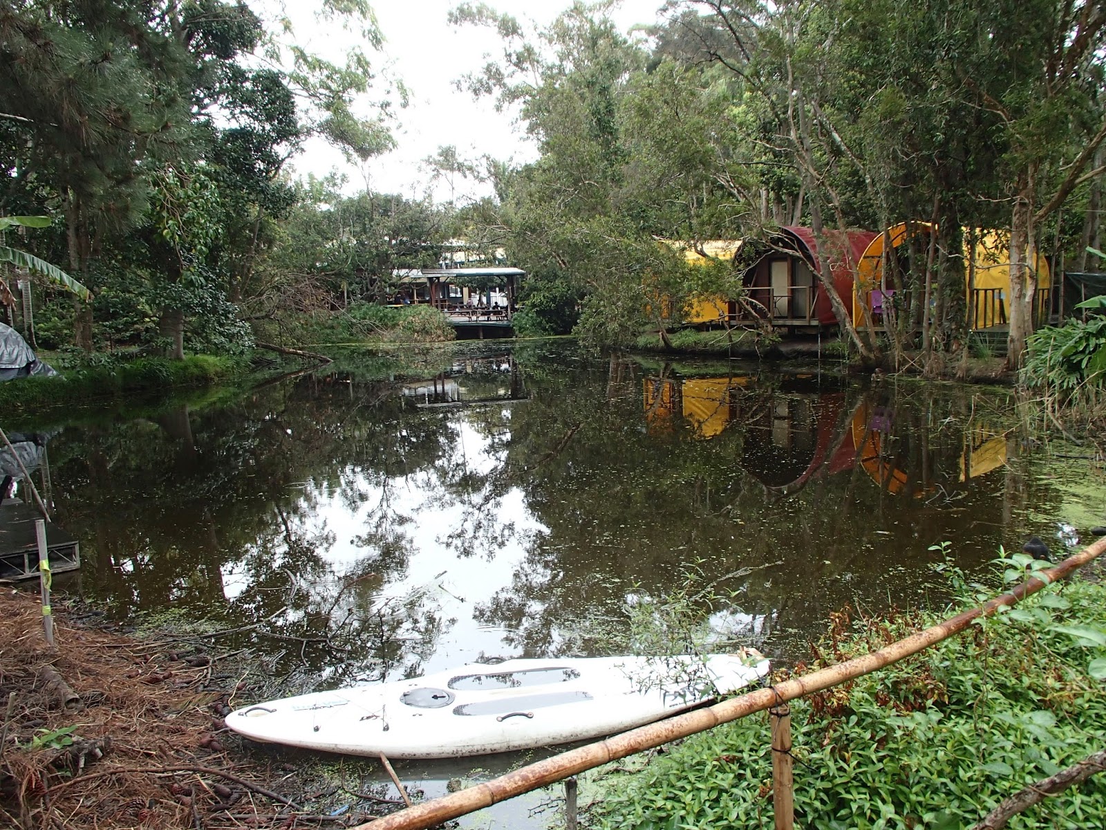
 A real trendy place to stay is about 15 minutes walk north-west from town central - The Arts Factory. This has wigwams, accommodation in an old bus, tents around a kind of canal/lake, plus the more normal dorm-room section seen below. Even a separate camping area out the back which is real popular with weekenders from Brisbane.
 You can do all sorts of new-age courses and treatments here and the place tends to be the hang of wannabe hippies. Lots of people find this a bit pretentious, but I don’t mind people bunging on a bit of side providing they don’t take themselves too seriously. If that sort of thing floats your boat, go for it. The associated Pighouse Movie cinema shows first issue movies and is good for a visit with lie-low type canvas seats. There is a frequent shuttle bus into town and to the beach.

UPDATE SEPT 2016 - for my second pass by that month I decided to stay a few nights at the ARTS FACTORY. Got myself a bottom bunk bed in what they called the WRECK DORM. Kinda thought the place was okay from the point of view of landscaping (lots tree, artificial lake yada) and variety of both accommodation options and people staying. Gotta say the arty thing seems to have faded a bit - only one sign offering palm reads, massage, reiki, theta, meditation etc and that lady was absent. But then maybe new-agers don't work weekends. The WRECK DORM was right on a boundary and a next door cafe/club (I think it had something to do with THE PIGGERY MOVIE joint) played loud (but not super loud) music. I don't think other ARTS FACTORY accommodation places would suffer.
But the real bummer was the kitchen -I could find no clean plates, cooking pots or cutlery in the communal kitchen? The FEW things of use were lying unwashed in the blocked sinks, along with a whole bunch of food scraps? There was such a lack of space on the food storage shelves and in the communal fridge that I had to jam my stuff into already occupied places, increasing the likelihood of someone interfering with my supplies? (and someone did indeed pilfer my stuff).
I managed to dredge up and wash some plates, a cooking pot and
some cutlery, but I never did find a bottle opener or a cup. And both tea
towels (only 2 in a very busy kitchen!) were so used and wet as to be a health
hazard.
When I went down to reception to enquire, they
told me I could hire most of those things by surrendering a photo ID or paying a
small fee. Confusion rules trendsetters - why didn’t they tell me that when I
checked in 20 minutes prior? And the longish lines at reception persuade
you to hang on to your stuff for the duration of stay – but no bag or container
is given to make carting them to and from your dorm easy and less prone to
dropping.
More
confusion – the hire thing is obviously intended to ensure people wash up their
stuff before handing back – but where did the unwashed stuff in the sinks come
from?
 Nice setting
 Kitchen doesn't look inferior to other backpackers' - believe me it was.

UPDATE OCT 2016 - Arts' Factory manager just responded to a review I did on TRIPADVISOR -
THE KITCHEN IS BEING REFURBISHED AS WE SPEAK.....HOORAY! Yes a long time coming, but it is extensive and a complete gut-out overhaul - Yew! No one is happier about that than the long term crew. A much needed improvement in operation by this weekend. The second point - there was always a bottle/can opener - it is the big obtrusive thing that is connected to a bench, so it cannot possible be stolen! It looks like a industrial vice! Maybe we should sign post it?
ACTIVITIES
Besides surfing, hanging on the beach, checking the viewpoints and walks around the Lighthouse, walking or cycling the long long beaches and exploring neat places like Broken Head Nature Reserve you can dive, do learn to surf courses, hang-glide off the highest point near the lighthouse, do all manner of new-age therapies and treatments, play golf, take joy flights, tandem parachute jumps, nature and hippy-spotting trips into the hinterland including the infamous Nimbin and shop/eat/booze til you drop in the neat lively main street precinct which has all sorts of places set up to service the trendy types and others who flock to the place. The Beach Pub, Railway Pub and the Great Western in the main street are great people watching places and all 3 usually have a good band or more between them - particularly the Railway Pub. The Beach Pub shows surfing movies on a big screen at other times and the great Northern always has contemporary sports happenings on several screens.

THE LIGHTHOUSE WALKING CIRCUIT.

Start at the car park above northern CLARKE'S BEACH lower right. STAGE 1 parallels the road and then drops to THE PASS. STAGE 2 goes over the headland to nice WATEGOS BEACH. STAGE 3 climbs from the other side of WATEGOS along a looping path to the LIGHTHOUSE. STAGE 4 drops down to near the start on the scenic (red) TALLOWS RIDGE TRAIL.
Abt 2.75km - just under an hour non-stop but you will stop for pix and maybe a rest or more. Surface good, slopes mainly less than VERY STEEP - the latter only short in distance. Some great viewpoints including the EASTERN MOST ON THE AUSTRALIAN MAINLAND, good for whale watching.
I find it hard to put a linear scale on these Google Earth images with big height differences - it is 760m in a straight line from the place markers of THE PASS and the LIGHTHOUSE.


WHEN TO GO
Byron is primarily a beach destination. Being in far northern NSW many people think you get good beach weather all year. I personally reckon June, July and early August can be marginal temperature wise - and this applies to any place south of Fraser Island in southern Queensland about 200km north of Brisbane. At the same time if my extended trip had no choice but these times, I’d stop in, but maybe just a day or two.
GETTING THERE
Just about all the Brisbane-Sydney buses divert in from the highway. Google for Greyhound-Mc Cafferty’s and Premier. Sydney is about 12 hours - Brisbane 2.5.
The nearest airport is Ballina about half an hour away. Coolangatta on the Gold Coast has more and cheaper flights - about one hour. Brisbane is the nearest multi-international airport - about 2.5 hours (a few international flights come into Coolangatta). All are connected to Byron by shuttle buses - byron easyBus and BRISBANE 2 BYRON - these also pick up at accommodation places in Brisbane and on the Gold Coast.
Despite the fact that a rail line splits town and the single crossing tangles traffic like crazy, the nearest passenger service is to Casino, about 1.5 hours away. Railway buses connect with Byron.
Blanchs Buses is the local Byron service with a route stretching from hinterland towns north of Byron to Ballina 30km south. You can get pretty close to Broken Head by catching a Suffolk Park service and walking along the beach for 15 minutes. Lennox Head, a good surfing and beach resort town with a nice uncrowded backpackers is on the Ballina run. I notice from Blanch's timetable they now have a Ballina Airport connection.
A good Byron and district site.
----------------------------------------------
If you have extra info or see mistakes, please post them below. If you have questions, please post them on THE FORUM, . I check the forum most days when not travelling, but not individual location pages like this one.


 I rate it equal in "untouristy" to Kos Sukorn, Libong and Yao Yai. Main activities are cash cropping and fishing. The 3 low key resorts on the west coast have minimal impact..
 I stayed at the original Siboya bungalow outfit -
  Nice lawn area behind beach and immediately south of restaurant - elcheapo 250 bungalows at left, more expensive 350s start at top. Private houses, some for holiday letting, start further south and to the north.
 You don't go to Siboya Bungalows for the beach - but maybe for the sunsets.
 About 300m north (and south) of Siboya Bungalows the beach improves, but it still aint Phra Nang.
 Some of the private houses at Siboya Bungalows.
  Owner Mr Chung. The perfect host - remembers your name and quietly asks every now and then if everything is okay. Image Siboya Bungalows.
 No TV, amplified music, computers at Siboya Bungalows. The only time the no-music policy is relaxed is at Christmas and at New Year where a buffet-dinner and dance is organised. A long-termer told me this is one of the few times when there is 100% occupancy. Image - Siboya Bungalows.
 My 250 baht bungalow at Siboya Bungalows.
 Beachside sitting-cabanas - perfect place for post-midnight discussions about the meaning of life.
 A regular mid-afternoon game of Tak Raw (volleyball type soccer) with staff, long termers and other guests. Mr Chung (foreground) is a keen participant. Image Siboya Bungalows.
 I hired a bike (right) and explored the rest of the island. Ban Siboya here is the main village, but is pretty basic - a few stores and restaurants - no ATMs, money changers, computer shops. Most roads are dirt, thru flat and lowly undulating countryside with rubber plantations, cash-cropping and rainforest. This concrete section stretches W to E across the island to the small pier for Laem Kraut on the inland side - about 500m down the slight hill from this shot.