done APRIL 2016
ATTENTION: THIS IS A PRETTY LONG PAGE WITH SEVERAL TRAIL DESCRIPTIONS. IF YOU HAVE BEEN SENT HERE BY A SEARCH ENGINE LOOKING FOR ONE PARTICULAR TRAIL, YOU WILL FIND:
KAIELIA TRAIL - immediately below
MOKULE'LA (MOKULEIA) ACCESS ROAD - abt. 40% down page
KUAOKALA ACCESS ROAD (EAST) - abt 60%
KUAOKALA ACCESS ROAD (WEST - 75%
KUAOKAL (RIDGE) TRACK - 65%
and PEACOCK FLAT CAMPING AREA - abt 55% down page


THE KAIELEA TRAIL
This is the most used trail in the area because:
* parking behind DILLINGHAM AIRFIELD is better than at other trailheads
* it offers a not too lengthy (2.3mi/3.7km one way) up and back trek which is steep and rough enough to satisfy users they have had a good hike - but not overly so. It won't worry people of average fitness providing they make a few rest stops. The trail is well defined and easy to follow and not technically difficult underfoot.
* views back over the western NORTH SHORE are definitely the best of any trail and by pushing on a bit further via connecting trails it is possible to get overviews of the LEEWARD COAST.
*people seeking a longer trek can continue via several trails to either eventually loop back to the KAIELEA for a descent back to DILLINGHAM or push on to stay overnight at PEACKOCK FLATS CAMPING AREA.
It is also possible to walk all the way to the southern LEEWARD COAST at YOKOHAMA BAY in the far west by descending the access road to the KAENA TRACKING STATION which is in this mountain area further west (see down page), but a permit from the DIVISION OF FORESTRY AND WILDLIFE is needed for this road.
KAIELEA TRAIL

Main road 930 along the NORTH SHORE is the FARRINGTON HWY from HALEIWA abt 8mi/13km to the east of the airfield. It ends abt. 2mi/3.3km further west but it is possible to take a trekking trail another 2.5mi/4km to the far western tip of the island at KAENA POINT.
Main road 93 along the LEEWARD COAST is also the FARRINGTON HWY (I guess the aim is to sometime join north and south sections in the KAENA POINT area) running all the way from the western suburbs of what is considered GREATER HONOLULU abt 21mi/34km east of its western end some 2mi/3.3km from KAENA POINT. Once again a walking trail goes to the point.
Pic details may be clearer if you click-expand image.
The trail starts in the south-east corner of the spacious and free parking area on the inland side of the airfield. After a flat few hundred meters it begins to climb WAI'ANEA'S steep northern escarpment.

The trail up the escarpment gains 950/1000ft (290/305m) in around 0.8mi/1.2km but because of 19 switchbacks, the slopes from moderate to steep never become ridiculously steep. Fit people will charge right up, normal types may need a stop or two - but this is no problem because there are many excellent photo opportunities over the western NORTH SHORE.

Please excuse the clumsy stitching of images via my elcheapo OLYMPUS's 'panorama' setting. These panorama shots usually click-expand nicely.

The escarpment track is not very wide but never becomes a bush-bashing exercise. Underfoot are plenty of rocks, roots and gravel - I reckon good shoes are a bonus here but was amazed at the number of people passing the other way wearing sandals and flip-flops. It looked like plenty of folk had decided on a quick mid afternoon up-and-back after a morning on the beach.
This trail was much busier than others in the area - I passed at least a dozen people on the hour or so I spent DESCENDING the KAIELEA (I did it as a LAST section of a much bigger trek starting further east - see TEZZA'S CIRCUIT down page) whereas in the previous 5 hours I had only seen 3 other trekkers, 2 cyclists and 3 off-road vehicles. I negotiated plenty of single step-downs but my 70 year old shot knees appreciated the lack of flights of stairs.
The upper part of the KAIELEA changes markedly. South of the escarpment edge it becomes much flatter (actually it undulates with the general gradient gradually up-hill) is relatively straight and widens into a gravel-surfaced road, probably part of the upper area's fire trails.
ON TO VIEWS OVER THE LEEWARD COAST.
The southern end of the KAIELEA joins the KUAOKALA ACCESS ROAD at a t-juncion. Take a left and continue a few hundred meters to the start of the KUAOKALA RIDGE TRAIL (from memory is is signposted 'KUAOKALA TRAIL' - no 'RIDGE') A short distance along is a gate thru which is the first of several overviews of the LEEWARD COAST.


But I didn't come UP the KAELIA TRACK - I approached the above area as the LAST part of TEZZA'S BIG WAI'ANEA LOOP (for want of a better name).....
(THERE IS ANOTHER KAIELEA MAP AND ONE MORE OF DODDS GREAT PICS TOWARDS THE FOOT OF THE PAGE).

The whole 15+mi/25km trek took me just under 6 hours, and I teamed up with a dude about 20% in who walked much faster then my usual geezer's shuffle.
Once again map details will be clearer if you click-expand image.
MOKULE'LACCESS ROAD - also spelled Mokuleia Access Road
I took this more eastern (3mi/5km) route into the mountains simply because it was closer to the nearest bus stop (in the coastal village of WAIALUA) by 2mi/3.2km. And I was in luck - I managed to hitch a ride from near the bus stop to the trail head.
At the trail head is a locked green gate with enough parking for a half dozen vehicles - plenty more along the adjacent FARRINGTON HWY which is a good 2 lane blacktop here.
BEWARE - island websites say theft from cars is high in this area - don't leave valuables in the vehicle: some even urge windows left down and glovebox open (less than half the parked cars I saw in several visits along the FARRINGTON did the latter).

Highest peak in this modified GOOGLE EARTH image is also OAHU'S highest - MT KA'ALA (40023FT/1217M) - GOOGLE MAPS shows a road/track up there from a bit further east (left - in this image because you are looking DUE SOUTH, not the usual DUE NORTH) on the FARRINGTON, but I don't know how good this is for driving/trekking - perhaps next visit.
WRONG!! Some time after writing the avove I came across a terrific MT KA'ALA trek account from DODDS on-walkabout - seems the hiking trail leaves from the opposite LEEWARD COAST.
The short road from the FARRINGTON down to WAIALUA can just be seen at far left.
Behind the locked green gate at the FARRINGTON HIGHWAY (from what I can gather only official FORESTRY AND WILDLIFE vehicles have access, but there is plenty of room for trekkers and bicyclists to pass) is a wide sealed road which tends to be flat and fairly straight for a km or so before the escarpment. This is less sheer than further west behind DILLINGHAM AIRFIELD - slopes vary from moderate to fairly steep but never killer. There are a number of bends but no tight switchback-like as further west. The sealed surface continues to the top but there were a few deep potholes higher up, something cyclists descending at warp speed and trekkers coming down in the dark without a torch (in this respect it would be a much better descent for late trekkers than that into DILLINGHAM which is too narrow and rough in the dark) need to watch for.
Two cyclists, one official vehicle and zero trekkers passed me the other way while I was ascending for abt an hour at my geezers' pace.

There are several good viewpoints along the MOKULE'LA, but not as many nor as good as from the KAIELEA. This one was from near the top - showing mid and northern NORTH SHORE locations: HALIEWA (yellow arrow), WAIMEA BAY - the southern most of the NORTH SHORE'S more famous big wave locations (white arrow), the northern end of the NORTH SHORE a few km past legendary SUNSET BAY (charcoal arrow) and closest camera; WAIALUA (red arrow).
PEACOCK FLATS CAMPING AREA

To the left of the locked gate at top of the MOKUKE'LA is this meadow. Empty here but I think this may be an overflow area - websites talk about each camp-site having a permanent shelter plus picnic tables, an outhouse (but no water) so I think the main camping area is back to the right. A couple walked up while I was studying an info board behind camera - told me they were the only campers. It was mid-week.
This looks like a nice campsite surrounded by pines and eucalypts and with good views back over the north shore. It is popular with off-roaders (who drive in via the TRACKING STATION), trekkers, cyclists,, hunters (much of the general area is made up of hunting reservations - don't wander too far off the tracks) and other outdoors types. Note you need a camping permit from the DIVISION OF PARKS AND WILDLIFE. Apparently the area can get quite busy on nice weekendss.
EAST KUAOKALA ACCESS ROAD
This begins immediately the other side of the closed gate at the end of MOKULE'LA ACCESS ROAD and runs for 2mi/3,.km (perhaps a bit more) to where the KUAOKOLA (RIDGE) TRAIL is signposted to the left. It is gravel surfaced, twisty and undulatiing - but with no killer slopes Initially the general direction is south-west towards the edge of the ridge and then it runs westward along or close to the edge for over a km. Surface was pretty good, although I have seen pix of off-road vehicles (this is the last stage of the access road from the TRACKING STATION to PEACOCK FLATS for vehicles who have come up from YOKOHAMA BAY on the LEEWARD COAST) having a terrible time in cut up surfaces after heavy rain.
One private off-road vehicle and one trekker passed the other way the 30 minutes spent along here.
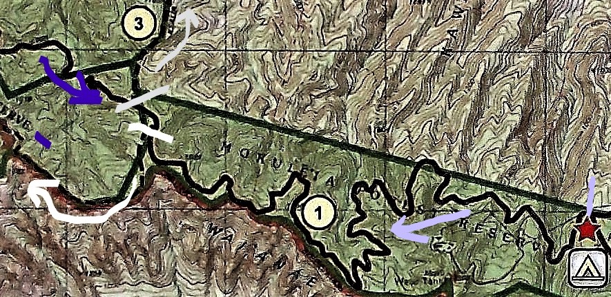
Stage 1 of my trek on the KUAOKALA ACCESS ROAD EAST (#1) started at the far right pale-purple mark at the junction o the MOKULE'LA TRAIL (notice the camping sign for PEACKOCK FLATS) and ended at the white mark at left, where the KUAOKALA (RIDGE) TRAIL (white arrow) takes off to the West.
A few hours later I returned on the roughly parallel KUAOKALA ACCESS ROAD WEST (indigo arrow) and turned down the KAIELIA TRAIL (grey/silver #3) towards DILLINGHAM AIRFIELD.
The above is modified from an information board map erected near the eastern start of the KUAOKALA ACCESS ROAD.
It was here I met another trekker who had come up from DILLINGHAM AIRFIELD. He planned to return via my proposed route along the RIDGE TRAIL and asked if I wanted to join him. Now I'm a bit of a loner but all the guides say don't hike alone, so I joined in. Turned out real well on account:
*he was a young bloke and walked 50% faster than my geezers' shuffle which allowed me to cover the ground in much less time than originally thought, particularly since like me he didn't believe in rest stops, except to snap pix. I think he was a bit surprised how I kept up on the many steep pinches along the way, but the fact is I'm a very fit old geezer.
*he had real good bush sense and seemed to take the correct track junction every time (he swore he had no prior experience of most of our route) whereas I only manage it one in three (I kid you not).
* he had his car at DILLINGHAM and I hoped to hook a ride with him back to the bus stop. Turned out even better - his home was in HONOLULU and so he could drop me on the outskirts of HALEIWA (I was staying in HALEIWA) along the way.

Pretty good information board at PEACOCK FLATS junction.

There are several good overviews of the lower NORTH SHORE along the EAST KUAOKALA ACCESS ROAD but the weather was setting in and my view was largely obscured by cloud.
We were lucky,it only rained slightly so the roads and tracks didn't become muddy.
THE KUAOKALA (RIDGE) TRACK
Let's distinguish this from the similarly named KUAOKALA ACCESS ROAD. The latter which for its western half runs roughly parallel a short distance inland to the north is a gravel road wide enough for two vehicles in most areas whereas the RIDGE TRACK is just that, a trekking track along the edge (or very close) of the ridge, too narrow, twisting, steep in parts, and rough for vehicles. It tended to have lots of rocks, roots and loose stuff underfoot. I reckon the steep pinches and rough surface would be too difficult for most cyclists.
However at no time did I think it too difficult for the average trekker - in fact normally the bonus of several good viewpoints down over the LEEWARD COAST would make this the better option for people heading west towards the TRACKING STATION. However the bad weather made views fleeting.

Doesn't look good.

The best view of the LEEWARD COAST I got thru a break in the clouds.

Our 2.5mi/4.0km/55-65mins westward trek along the KUAOKALA (RIDGE) TRAIL (white arrow - #2) started at the white junction lower center and ended at the junction with the western start of the KUAOKALA ACCESS ROAD (indigo - #1) near the top left corner.
The far left road coming up from the south indicated by the red arrow is the permit-only TRACKING STATION access road from YOKOHAMA BAY.
We saw no other people along here.
WEST KUAOKALA ACCESS ROAD

We began our 50/60 minute eastwards trek back along the WEST KUAOKALA ACCESS RD (indigo #1) at its junction with the RIDGE TRAIL at the indigo mark top left.
I remember the transition was pretty seem-less - but I don't remember seeing any spaced-out structures (the TRACKING STATION is pretty close) or even the parking area near the junction (this would be ideal for permit holders who have driven up from YOKOHAMA BAY and intend to trek the RIDGE TRAIL-WEST KUAOKALA RD loop.
The latter was very similar to its EASTERN SECTION - winding and undulating but never excessively steep, surface okay gravel and supposedly occasional glimpses of the NORTH SHORE which we didn't see because of the weather.
After about 2mi/3.3km (maybe a little more) we reached the T junction to turn left down the KAIELIA (yellow #3) to DILLINGHAM.
We saw 1 other trekker and one (private) off-road vehicle along WEST KUAOKALA RD.
THE FINAL LEG - DOWN THE KAIEL1A TO DILLINGHAM
I have already given details of this trail up page - suffice to say going DOWN it at the end of a very long day was pretty good. We made great time and I found myself at the DILLINGHAM AIRFIELD PARKING AREA nearly 6 hours after starting further east of my starting point at the MOKULE'LA ACCESS RD trailhead.

Unfortunately the rudimentary cropping tool on my computer did't allow me to cut out the trails and roads to the left (west) of the KAIELIA - so concentrate on the yellow #3 trail. The dotted line is the go for trails (solid, winding for roads) - the straight solid lines are mainly borders of hunting zones and similar.
THOSE VIEWS

In the downhill direction, views face you which makes sightseeing easier than when climbing. My shot up page over the airfield from the trail was suffering a bit from the bad weather - this is another much better one I borrowed from DOBBS: on walkabout
Note the clearer conditions make the north-west tip of the island fairly easy to see.
The ride I got to HALEIWA from my new hiking buddy was a God send - I ended up much earlier than I thought sitting on the rear balcony of my digs behind HAWEIWA BEACH sipping a cold beer while watching a fashion shoot my AIRBNB hostess TERRI had arranged for a boutique owning friend.

Good combination: downing an ice-cold Kona while scoping out a pretty wahini.
ATTENTION: IF YOU HAVE EXTRA INFORMATION OR SEE MISTAKES, PLEASE POST BELOW. BUT IF YOU HAVE A QUESTION, PLEASE ASK IT ON THE FORUM PAGE WHICH I CHECK FAIRLY OFTEN - WHEREAS I REVISIT THESE INDIVIDUAL LOCATION PAGES ONLY OCCASIONALLY.


1 comment:
شركة نقل عفش بحائل
شركة شراء اثاث بحائل
شركة نقل اثاث بحائل
شركة العربي للخدمات المنزلية
Post a Comment