skip to main |
skip to sidebar
Jatiluwhih Rice Terraces
visited June 2016
Outlook from one of the several roadside warungs (cafe/restaurants) in the small village of Jatiluwih.
Pre-sunrise from our accommodation. Agung, Bali's highest mountain, is the higher peak.
Although JATILUWIH is supposed to be THE top rice growing area for visitors I'm not too sure.
I thought the terraces were more spectacular around west Bali's BELIMBING, slightly easier to access on arrival and quicker to reach from Kuta at TEGALLALANG a bit further east, the countryside maybe a bit nicer to walk thru at east Bali's SIDEMAN - and of course if you want to walk an attractive rice growing area with quick access from Kuta and a heap of nearby accommodation, the UBUD RICE FIELDS do the job real well- although they can't match the others terrace-wise.
But yeah, JATILUWIH is a pretty good combo of these other places - the terraces look pretty good, they are very easy to access from the village, the whole area is not excessively far from Kuta and the busy south, and the general countryside is attractive. And certainly if walking tracks thru such countryside is your thing, it has more and longer of these than the other places.
Jatiluwih is slightly less than 60 km from the airport - subtract a few for Kuta. The trip should take around 2.25 hours unless very late at night or early am.
Jatiluwih's surrounding rice are stretches in a narrow V south of the village, roughly following several parallel ridge/gully lines. The east, west and south place markers indicate the directional extent of the walking tracks. It's hard to put a linear scale on images with uneven relief - it is 3km in a direct line between the 2 place-markers at "village" and "south.
The village is a tiny gem - here is the eastern section from our accommodation's restaurant. There's a whole bunch of warungs/cafes overlooking the rice fields along this section. The best IMHO is BILLY'S TERRACE CAFE right at the top where the road does a sharp right.
More of the same a little further up the road. These are good images to click-expand.
Much the same area from the top of one of the ridges in the rice fields. There is a rather deep gully between this and the village.
Jatiluwih village from Google Earth. The touristy section pictured above is between the two placemarkers. I ventured up around the corner - we have the typical Balinese ribbon village with a few very short streets off to the side. Straight line distance between the 2 place markers is 375m.
Village beyond corner. Not touristy at all. No doubt you could get a very cheap meal but our accommodation TERAS SUBAK and other places in the touristy zone could do that. But that area had few stores - there were quiet a lot of small places along the above strip if you needed the basics.
OUR ACCOMMODATION
TERAS SUBAK was one of the first places reached entering the village from the eastern side. The road in shot was quite busy during the day with lots of day-tripper cars and buses arriving. After dark things were pretty quiet until about 0530 when workers began congregating across the road from the camera prior to setting off into the adjacent fields - see below.
TERAS SUBAK (the low place associated with the 2 white vehicles - the higher roof is a rather flash restaurant popular with day trip coach groups) from the rice fields. The peak behind is GUNUNG BATUKARU, Bali's second highest peak at 2276m. It has Bali's biggest crater (shaded area at top) but this is open to the south west side, so there is no lake like nearby BATUR. Bakukari is actually the western most of the string of volcanoes which make up Bali's central vocanic area.
Be aware when booking accommodation that a lot of places giving a JATILUWIH location are actually several km outside town - often in neighbouring villages.
TERAS SUBAK was the least expensive place we could find right in town at $aud29 (about $us21 at the time) with breakfast - as a matter of fact it was one of the better value joints in the whole area.
Of course "better value" implies it was an okay place - and indeed it was. One of the better upcountry joints I've stayed at over the years.
Our room (one of 4) was spacious, had plenty of natural light and okay lighting at night. No aircon, but a fan was fine - places this high don't get real warm. You can see the clothes storage and sink at back - the bathroom was behind the wall in left of image - not too pokey with good quick hot water.
The king size bed had a soft mattress. I prefer something fairly firm but I must admit this one was deliciously comfy. The general condition of the room was a bit rough around the edges, but well short of the need to refurbish.
Outside was a nice patio - a good place to sit and watch the passing parade on the main street. Not to mention the rice fields and sunrise.
The free wifi was patchy - mainly because the staff kept forgetting to turn the modem on each morning.
Outlook from our patio - people walking in the fields mid shot (better seen if you click-expand) are on the main walking track which starts about 30m east of TERAS SUBAK.
TERAS SUBAK roadside restaurant. Views here not as good as up the street (tip - the joint closest to the corner [BILLY'S TERRACE CAFE]was best in this regard) but place attracted a reasonable number of passing day trippers and was popular with locals. The latter may have been because prices were typical Bali budget restaurant in level - very good value: it's hard to get a cap cay for 20k (abt $us1.50) in touristy areas these days. The inclusive breakfast was basic - a choice of omelette, toast or pancake plus tea/coffee but big eaters can find plenty of extra stuff on the pay menu. The food itself wasn't too bad at all, the beer cold and the service pretty good.
WALKS
Some of the rice field walks (coloured routes - others are roads and lanes) around JATILUWIH. These signs were placed at the start and finish of each route and also at strategic spots along the way.
THE SHORT WALK
This is a popular one, because not only does it NOT take up a big chunk of a day-tripper's time (often these dudes have other up-country destinations on their dance card) but also gives a very good exposure to rice growing country - it's all there: the terraces, irrigation and drainage ditches, threshing areas, other produce growing areas, nearby field workers and oxen etc.
Short walk in yellow - about 650m long/say 25mins with stops. Interestingly, it doesn't seem to be on the map-board one image above this. Nor was it on the hiking map our accommodation gave us. Maybe it is a very recent addition to the area's treks - done to provide day-trippers with a nice short informative walk. Other walks are a bit time-consuming.
My "start" and "finish" points are of course interchangeable - I did them that way because most walkers seemed to be doing the same. I reckon the day-trip guides might like it because their patrons have an excellent elevated (above the road) warung right opposite the finish (BILLY'S TERRACE CAFE). Views are definitely better in this higher southern part of town. However if you are very unfit you will find the opposite direction easier - there is the warung/restaurant of TERAS SUBAK virtually across the road from the finish and an elevated flasher place behind. Note TERAS SUBAK views not as good but food/drink prices a steal.
The SHORT WALK starts across the main road 30m east of TERAS SUBAK. This path along the top of one of the ridges is also part of the LONG WALK.
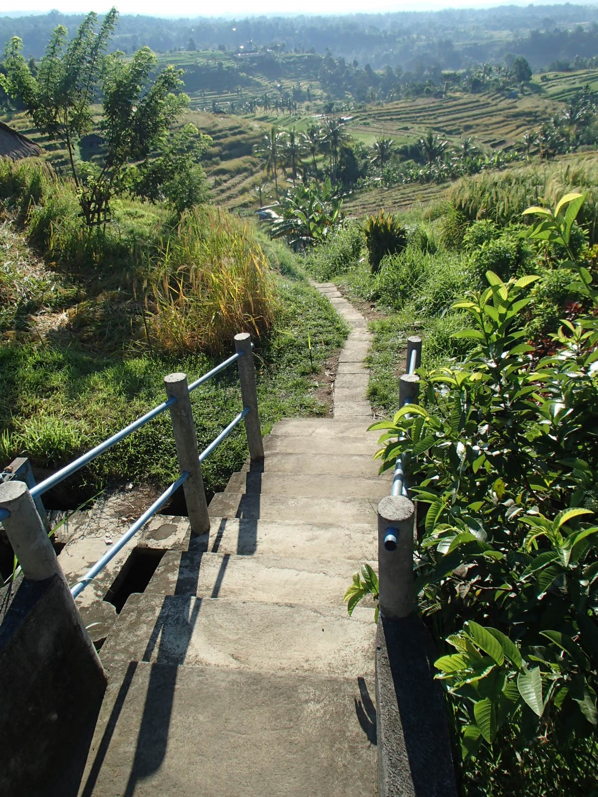
A short distance behind camera a sign directs SHORT WALK trekkers hard to their right - where the track quickly starts to drop into the gully which parallels the above ridge.
This is shot from towards gully bottom looking back up the track - slope not too steep if you decide to walk the route in the opposite direction.
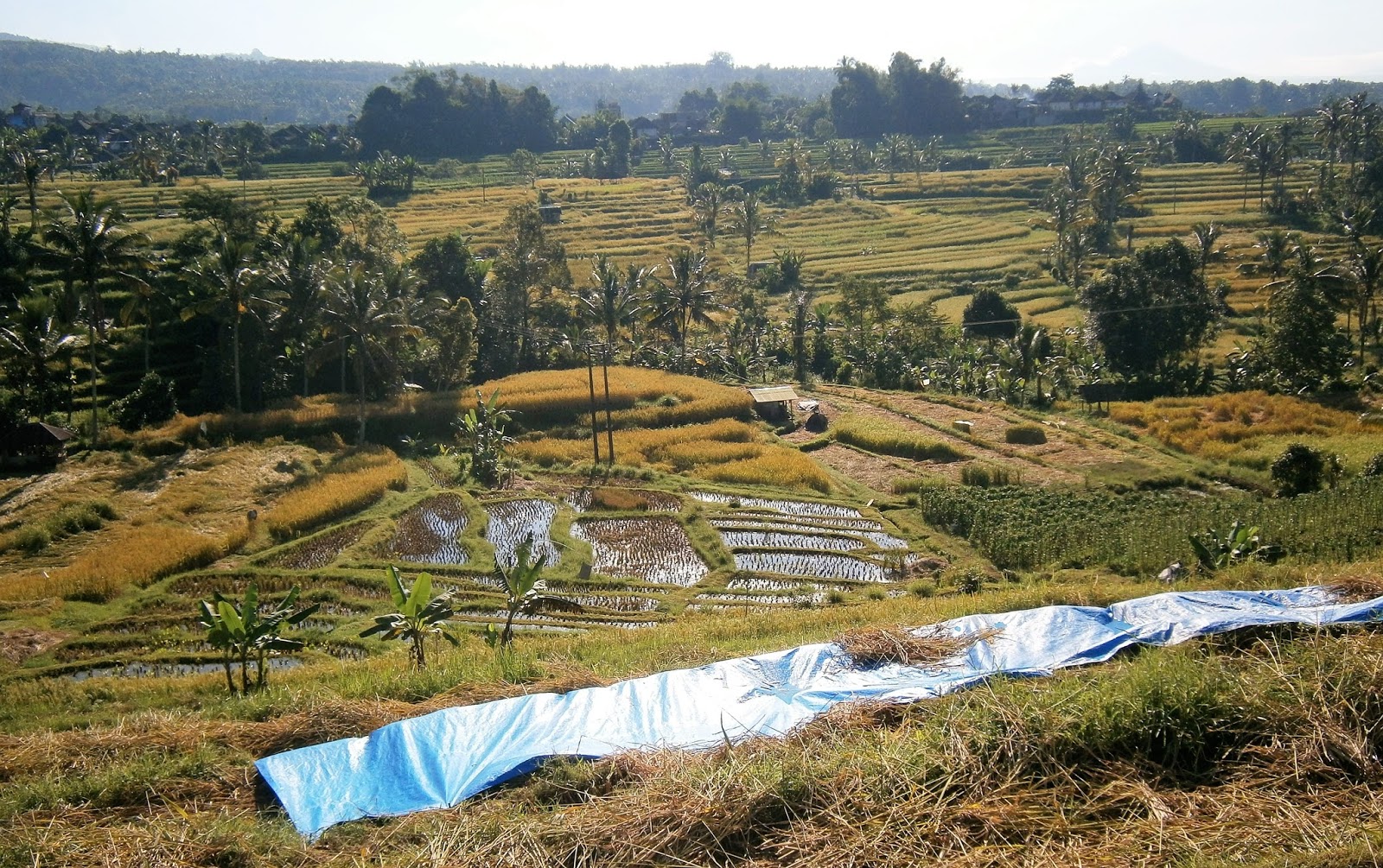
At the bottom of the slope you turn hard left and begin to move along a creek/irrigation ditch for abt 300m. This is real nice country: views of rice terraces, other produce areas, some uncleared patches of bush and bamboo, water buffalo in pens, field workers up close - yada.
After following the gully bottom for several hundred meters the sign leaves no doubt where you need to do a hard right to begin the climb back up to the village.
This climb has the steepest gradient and most steps of any walk in the area. However you are climbing for only 200 meters max and so it will not tax people of reasonable fitness.
If unfit, it may be better to start here and descend this slope - as said, the climb out of the gully at the other side is a fair bit easier.
The view immediately after regaining the main road right at the tight corner about 450m up the street from the starting point which is opposite the last building top-center of image.
Outlook walking back down the main road is not bad either. The track from the gully comes up roughly where that structure is top right.
THE LONG WALK
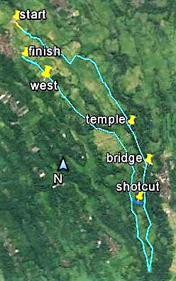
Long is the correct term - this one goes for abt 7.5km and took me the best part of 2.5hours (although I ambled along and had plenty of stops). It starts at exactly the same point and finishes only 30m further south than the SHORT WALK .
No linear scale on this image - straight line distance between "start" and "shortcut" place-markers is 2.6km
Starting point once again 30m east of TERAS SUBAK, These panorama images click-expand nicely.
Hands off message to tourists.
Go past the signed-posted right turn for the SHORT TRACK - a short distance further along the ridge the path does a dropping left turn, quickly followed by a right. Note "TRACKING ROUTE"sign keeping walkers on the straight and narrrow. Well not so narrow - most of this walk was on similar width "lanes" - locals use these to motorcycle around and transfer the harvest and equipment on compact 4 wheel things. Very easy underfoot of course - no rocks, roots, steps etc.
The few hundred meters along this section is the steepest of the 7.5km (fits my category of FAIRLY STEEP, which is under my STEEP, VERY STEEP, HEARTBREAKER categories - not to mention DON'T SEND FLOWERS). I also did it the other direction and can say it would force unfit people to have a rest.
Cool local
Nice
About 15 minutes into the walk you hit this intersection. Bear left. The right hand track is a diversion which I deal with down page.
Image a bit blurry - I shot this on the move.
About 35mins into the walk the track descends into a wooded area, does a right and left and in another 10min reaches this temple area (abt 2.2km into the treck). This is the PURA LUHUR BESIKALUNG. It looks to be a pretty imposing structure, but was closed to public entry to 2 times I passed by. Good news is that there is a fairly modern bathroom block a short distance to the left of pic.

Past the temple the track parallels a small river. Vegetation is much the same as above - not too much rice growing down here, but certainly some vegetable plots and quite a few fruit trees incl citrus and banana. Also some good bamboo patches. After about 10 minutes you reach this bridge - the path on the other side leads to the lower section of a fairly big village called BABAHAN - the LONG TRACK needs you to keep going this side to the right of image. Note far right of image the path-side TRACKING ROUTES sign as shown up page - complete with "YOU ARE HERE" arrow. The locals have gone to a lot of effort to make these walks user-friendly.
Past the bridge the track continues to follow the river. Scenery and activities are similar, in addition to which are several chicken hatcheries and a piggery.
Less than 10 minutes from the bridge you will come to an intersection - the track leading uphill to the right is a SHORTCUT which cuts about 2km off the walk. I found this short section fitted my STEEP category - a real good work-out. Once again less fit people may not be whelmed.
If you don't want to shortcut and to do the full walk, continue alongside the river (I think the track may veer left a bit at the intersection). This continues for another km or so where another sign instructs you to turn hard right, where you begin the slow gradual climb back to JATILUWIH village.
Slightly less than a km on from the turning point you will reach the intersection where the SHORTCUT rejoins. In hindsight I have to say the SHORTCUT makes sense - there is not too much to see on the longer almost 2km loop. I did it because I could say I had done all the sign-posted walks**
**that's not to say that keen trekkers cannot do more - these tracks have branches and extensions which lead to local roads and you can access many neighbouring villages and attractions like temples if you are real keen. TERAS SUBAK'S map has a reverse side which shows many of these in all directions around JATILUWIH - of course a rental moped or your own vehicle would make this much easier.
The return track follows a ridge all the way to JATILUWIH. Slopes mainly gentle to moderate - maybe one short section reaching the lower part of FAIRLY STEEP. Note the workers center-left of image.
Finally back to the haripin area of JATILUWIH. That's the nicely positioned BILLY'S TERRACE CAFE at right. I resisted a visit - I scuttled down to TERAS SUBAK near the last roof in image on account Lady Tezza would want reassurance I hadn't been trampled by a water buffalo in my near 3 hour gallop thru the boon docks. Besides, the beer at TERAS SUBAK was likely to be colder than BILLY'S on account of fewer customers.
THE DIVERSION
Seen in white above, this is not really a short cut of the LONG WALK on account it is roughly the same distance at 1300m (and in fact takes a bit longer because the last 25/30% narrows to a bush track). But okay, it was on the trekking maps and so I had to check it out - pleasant enough, it heads along a parallel ridge above the main track, rejoining just short of the temple.
Interestingly, TERAS SUBAK's map showed a variation - a short track leading off from roughly the "narrows" place-marker and heading left towards the return part of the blue LONG TRACK which terminates at "finish". I couldn't see any evidence of the cross track but it was dead easy to miss these narrower paths if un-signposted. And not being shown on the official map boards, perhaps the locals thought it didn't warrant a sign post.
Here's the DIVERSION heading off to the right from the main LONG TRACK about 15 mins from the start near TERAS SUBAK. The diverstin branch is not as wide or paved as well as the main track, but is still used for agricultural purposes and so is pretty good - at least for the first 70% or so.
Some real nice countryside along here.
After about 800m the agricultural laneway comes to a dead end. At first it's hard to see this narrow continuation of the route - it dives down the side of the ridge and into an area of bush and non-rice farming.
Note the flattened rice in the pic - there were lots of instances where fairly large sections of a rice field had been smacked down. Locals told me a recent storm with very strong winds was the cause.
The route becomes a real narrow track thru mixed farmland and bush. After a few minutes it crosses this stream, after which it begins a short climb to....
....emerge thru the gap at right onto the main track. I walked past this point (slightly north of the temple) twice previously and missed the side track completely. In retrospect, the usual tracks diagram at far left indicates where to divert if you want to do my DIVERSION walk in reverse.
From this intersection you can either turn left towards the camera and go back to the village at the TERAS SUBAK end (abt 2km) or turn right and complete the LONG WALK - back to the hairpin area of the village is abt 3.5km via the SHORTCUT or 5.5km via the full route.
THE EAST TRACK
This is the only track on the official tracks board that doesn't start in town. Having done it I can report that it doesn't really show anything new, so if you are a bit bushed maybe this is the one to give a miss. On the other hand if like me you have to do all the tracks and like to see the full area, it is not wasted time.
In a way it is a bit like the DIVERSION - it is another that ends with a haul along a very narrow path and a final climb up to join the LONG WALK track.
To reach the start you need to walk along the main road north-east of JATILUWIH for abt 700m from the TERAS SUBAK end of town. This is thru pleasant countryside although the road (it's not a major arterial route) is quite busy.
Total distance from "start" to "warung" is about 1400m. Downhill except the last 150m or so - slopes gentle to moderate.
The start of the track is well sign-posted. The first few hundred meters similar in appearance to the LONG WALK track. About 250m in you turn hard right and head downhill past a walled religious shrine or similar. Not far past this the track turns left again and continues downhill thru some nice rice growing country. After about 400m the wider track ends...but similar to the DIVERSION, there is a much narrower path which continues a short distance to where it reaches a creek and drainage ditch. Here you should turn left and continue to walk along the concrete top of the drainage ditch. After about 300m......
....you will see the building top right. I recognized this as the only open warung on the LONG WALK track. Near those bushes ahead I found a path which led uphill (I think it may have started with a few steps) just past the warung on this side, where you can turn left and quickly reach the LONG WALK track.
It's about 1km back to the TERAS SUBAK part of the village on the LONG WALK track.
GETTING THEREEvery driver in the south touting for a fare can take you up here. It is such a popular day trip many can show you pix of the area. Plenty of tour companies run vans and coaches to the area. As said before, many have JATILUWIH as part of a multi-destination tour. It's kinda a natural for people also wanting to see the LAKE BRATAN/BEDEGUL region not too far to the north-east.
Our driver from Sanur approaching the toll booth about 3km short of JATILUWIH. Cost is 45k + 5k for parking. Keep your ticket - there are similar booths at the start of walks: cost 20k but when we showed our ticket the dude waved us past. I guess van and coach passengers don't get an individual ticket at the initial toll booth.
We paid 400k for the trip up from Sanur. I thought this a bit high but at the time I was too lazy to go get competitive quotes. We arranged for the same driver to come up at the end of our stay and transfer us back down south. I have found up-country drivers use the "captive market" and less competition things to charge outrageous prices.
Trip took 2h 10mins - it's not very far but the traffic for 70% of the trip is horrendous. Btw - the last 8km or so leaves the main arterial route and takes a side road to JATILUWIH. This is badly broken up and very narrow in parts, esp. through villages. I don't know how those tourist coach drivers do it.
From Kuta time taken should be about the same and prices similar (although if I had the time, I'm sure I could get it down to 300k each way).


1 comment:
Thanks for such a thorough guide, it was super useful for us. This kinda post would be even better with a link to the route on Google maps, like in the screenshots. Thanks, Jethro.
Post a Comment