
WHICH ONE MUM?
The Yosemite region has dozens of trekking trails. There is a bunch of good ones in the north of the park along Tioga Pass Road and in the Hetchy Hetchy resevoir areas, others in the south including Mariposa Grove, a great selection in Yosemite Valley itself and more just to the valley's south along Glacier Point road. You can see what's available in these areas on the National Park's Hikes page.
VALLEY TREKS
I had a short Tioga Pass Road gallop earmarked but as usual I was running late (too many great places along highway 395 up the eastern side of the Sierras) and drove across the high and scenic Tioga in the dark. So my trekking was confined to trails heading up from the valley itself. National Parks has a great map showing the various trails and a lot of other valley detail HERE
No shortage of choice from the valley - the big daddy of day hikes** is the HALF DOME trek, a tough but very scenic 14mile/23km round trip walk which gains 4800ft/1500m. However the last super steep section has cable-assist, and to keep crowds down on this tricky section National Parks has a lottery system for permits, I didn't have a permit and worked out probably the next best was the 4 MILE TRAIL-PANORAMA TRAIL loop.
**there are overnight treks too. Hell, the awesome JOHN MUIR TRAIL starts at Happy Isles in the valley and goes 210 miles/338km to Mount Whitney meandering thru King's Canyon and Sequoia National Parks. If 338km is a bit short you can branch off onto the PACIFIC CREST TRAIL of WILD movie fame.
 Didn't meet anyone as cute as Reese on my treks.
(image Pittsburgh Post-Gazette)
THE BIG LOOP - 4 MILE TRAIL/SENTINEL DOME SIDE TRACK/PANORAMA TRAIL

My BIG LOOP involves the following: 4 Mile Trail from valley floor to Glacier Point - side trail to Sentintel Dome - Panorama Trail back to valley floor.
GLACIER POINT is one of the most visited viewpoints in Yosemite. I didn't fancy the 30mile/49km drive from the village but the hike up the 4 Mile track sounded okay - particularly when I read there are some great and unique outlooks along the way.
And having reached Glacier Point, I'd be a mug not going a bit higher to SENTINEL DOME. Accounts say the extra height gives views even better than Glacier Point.
But then I'd have to get back to the valley. Didn't have a partner to drive me down and apparently it is real hard to score a vacant seat on one of the buses which do the trip. I didn't want to backtrack down the 4 Mile. Then I read up about the really long Panorama Trail which includes the popular Mist Trail with its views of NEVADA and VERNAL FALLS.
 START - white far left FINISH blue upper middle.
4 Mile Trail in white, side trail to Sentinel Dome in yellow, Panorama Trail in blue.
This is a loong walk at 16.4miles/26.2km. Fair bit of climbing/descending too. The valley floor at the start is 4000ft/1120m above sea level. Highest point is at Sentinel Dome - 8127ft/2477m, meaning lowest to highest is a difference of 4127ft/1258m.
Getting back from the end of the Panorama to my rental at the start of the 4 Mile seemed easy - use the free valley shuttle buses which run around the valley floor. Didn't quite work out that easy.
 I spun and tilted the image to try to bring out the verticality involved. Here we are looking from the north directly south.
COMPARISON WITH MY GRAND CANYON TREK
My Grand Canyon epic less than a week before was not exactly a stroll in the park, but the Canyon stroll was actually shorter (23km v26), had a lower highest point (7200ft v 8127), less verticality (3100ft v 4127) and a shorter duration (9 hours v 10).
You are probably not surprised to know the Big Loop left me feeling considerably more used up than after the Grand Canyon thing. But it wasn't the distances or uphill slogs - one main factor whacked me around more; the killer descent on the Mist Trail. More later.
PREPARATION
I'm a seriously old dude but very very fit. However I knew the distances, slopes and heights involved both at the Canyon and in Yosemite required extra preparation. Check the link above to see what I did. It didn't hurt that after the Grand Canyon I had done a trek to LONE PINE LAKE, about a quarter of the way up the MOUNT WHITNEY TRAIL (and as far as you are allowed to go without a permit). This was only a little over 4 hours return but involved higher altitudes again (the lake is at 10500ft after a 8300ft start and is thus good for altitude acclimatization).

Lone Pine Lake with Mt Whitney behind. Picture pretty smokey due to big fires in the south-east Sierras. Also made Yosemite views less clear the next day. This is a nice shot to click-expand.
I also had my hiking poles, good trekking shoes and socks, trail mix/power bars and electrolyte. I carried less water than in the Canyon. Not only were temps lower but water is available at Glacier Point, so I figured 1L was enough for the 4 Mile Trail (water available at the top) and 2 would get me back down the Panorama.
THE 4 MILE TRAIL
4.7miles/7.5km 4000ft/2200m to 7200ft/2200m for a 3200ft/approx1000m climb
 This diagram on display in the YOSEMITE VILLAGE VISITORS' CENTER shows the route of the 4 mile trail starting just out of frame lower right to Clacier Point top left. The highest point on the image is Sentinel Dome. Much clearer when click-expanded.
 0915 - I was lucky to get one of the last parking spots in the roadside area opposite the trailhead. This was on a Saturday morning in the August school holidays. Note a lot of people were heading off to the right where there are some real nice picnic areas and flat walking trails along the Merced River. If you miss out on a park here the best bet would be to head on a few km to the one of the Village's big parking lots and catch the free El Capitan shuttle bus which drops off here. There is a bigger picnic parking spot off the main road a short distance behind the image but the one way Southside-Northside Drives mean a 20+km trip to get back there. If you are running late maybe check it first on the way in.
I hit the trail at 0947 after a false 0930 start - I left my hiking poles leaning against the front fender - DUH!
The first 5 minutes of the trail are along the valley flat. When the climb begins the slopes are pretty moderate and seldom get steeper the whole way. There is no section I'd class as steep although less fit dudes like my circumferrentialy-enhanced internet friend Kananga (the only man [still alive**] who can hoover a 12inch/300mm coconut-cream pie in under 35 seconds) may disagree.
**might have something to do with his sensational squeeze - the super sensual Siam Soonay who is the CPR champion of central Kranji - as I pointed out on the Grand Canyon page, this scintillating sweetheart has given the kiss of life almost as often as a pash of passion.
The surface of the lower trail and some of the upper-most section is badly broken bitumen - may have been sealed to assist wheelchairs but even when in good condition the slopes would demand an Olympic-class wheelchair athlete or a big super-fit pusher (put that wheelchair away Kananga - Soonay aint a big dude). The broken/discontinuous surface now makes it impossible for wheelchairs. Skaters should shelve any plans of fanging down-hill - check "discontinous" above. At the same time this surface is not a difficult one to walk - ditto unsealed central areas of the track which are relatively smooth underfoot. Shaded by trees and cliffs over 50% of the way. There were few stairs, mainly single. A moderate number of trekkers heading up, but not crowded. Few descending - may be more later in day.
 About a mile up the track the forest clears a bit and you start to get some views of the valley. That trail you can see top-center of image is the start of the Upper Yosemite Falls track.
 A bit higher gives a reverse tunnel view of the main valley to the west. The classic U shape of the glacier-cut valley comes out well here. That's the famous El Capitan of climbing fame at right. Smoke from big south-west Sierra forest fires makes image less clear.
 Higher still starts many outlooks of the lower and upper Yosemite Falls (black arrows). There are very few other valley outlooks where you can see both falls. Note absolutely no water falling (marks are discouloured rock/moss) - these falls are normally dry by September but California's prolonged drought saw same earlier in August.

 I reached GLACIER POINT at 1231. That's 2 3/4 hours for the 4.7mile/7.5km climb - an average of 1.7mph/3.1kph, faster than my roughly equivalent (steepness and length) Bright Angel Trail route out of the Canyon - maybe on account the 4 Mile was at the start of my trek and considerably cooler.
Glacier Point was quite crowded - on account of the carpark only 200m away. Check the smoke.
There is a cafeteria and gift shop up here. WCs of course plus a spot to refill water bottles - covered by bees when I called by. Not for long.
 One of the two viewpoints has a good outlook of the valley floor - that's CURRY VILLAGE of camping/other accommodation fame image-central. YOSEMITE VILLAGE is out of frame higher-left.
I would be finishing my big trek near far right of frame about 7 hours later.
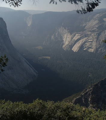
 The outlook towards the northern face of the valley was pretty special too. Check HALF DOME, highest point at left, and the spectacular TENAYA CANYON glacier-cut hanging valley to its left. The black arrows point to NEVADA FALLS (top) and VERNAL FALLS. I'd be doing the excruciating descent alongside them about 6 hours later. Click-expand may make details clearer.
 Schematic at the viewpoint labels features.
4 MILE TRAIL SUM UP
I was feeling so good at the top of the trail I could have gone a posse of pole-dancers without raising my pulse. On reflection, a bunch of hot ones would blip it up a beat or two. Okay, I'll come clean - the old ticker would be beating so hard it would blitz the sensors on my Fitbit. Send for Nurse Betty!
 I'm thinking Nurse Betty may not be best choice in the heart calming stakes. Who cares? Send for her anyway!
Um, sorry about that - got carried away.
Although it gives me some ideas for my upcoming birthday bash.
POLE DANCER IMAGE REMOVED ON DIRECTION OF GOOGLE - CRIKEY, WHAT IS THIS WORLD COMING TO WHEN READER WOWSERS DICTATE WHAT WE POST AND VIEW?
Whoa!! But wait a minute - my 70th was last week! DARN- MISSED OUT AGAIN!!
image pinterest.com
Although fantasy above is maybe a bit in front of reality below....
 ....I gotta admit my fiscal situation** means Lu Lu is more the go.
image Baltimore Sun
**maybe it wasn't such a good idea to short the Euro. But when are people going to wake up that the 'Tuero' as we know it now will not exist in the not too distant future?
Could a fit person do the 4 Mile without my extra work-outs? Easy.
Could a person of normal fitness (which these days is pretty unfit) do it? I think so, but lots of stops would be needed and they might suffer next day.
Could a Kananga do it? No chance. The circumferencially enhanced Kranji Kid has 2 rest stops and a defibrillator station on the 5 steps up to his preferred Prue's Parisian Patisserie on the Payoh promenade.
THE REVERSE TRIP - quite a few people ride up and walk down. I reckon even unfit people could manage this (maybe not the grossly unfit). It is not so steep and rough that it is a knee-wrecker so most people should have few problems with this. But cut those toe nails - even ordinary length toe nails can get miserably sore banging up against the front of shoes on prolonged downslopes.
SIDE TRAIL TO SENTINEL DOME
This is a relatively short one at abt 1.6miles/2.6km one-way from Glacier Point. Height gained is 927ft/almost 300m.
For car carried crazies a shorter path leads in from a Glacier Point Road car park which is a good 7miles/12km from the Glacier Point car park (and abt 13miles/22km from the start of Glacier Point Rd which in itself is quite a long way from Yosemite Village). The walk in is pretty flat except for the final haul up the side of the dome.
 Tilted Google Earth image shows path from Glacier Point to Sentinel Dome in yellow. Glacier Point Road parking area is out of frame top left. You are looking slightly south of due east here.
I found the track between Glacier Point and Sentinel Dome not too rough and of similar steepness to the 4 Mile Trail. However the penultimate 400m steepened, moving out of my "moderate" into "fairly steep" category. And....
 ....the last 200m up the side of the Dome was a step up in gradient again. We are talking properly "steep" here, but no way into "heartbreaker" territory.
 Sentinel Dome is one of the highest points on the valley rim. Notice it is roughly equivalent to the top of Half Dome left of image. Compare this to the shot from Glacier Point up page.
 Even though I passed no-one on the climb from Glacier Point, there were a fair few people clambering around the Dome (although nowhere near as crowded as the Point). This is because the Dome is not too difficult to access from the car park on Glacier Point Road.
SIDE TRAIL SUM UP
The short distance up from Glacier Point will not trouble fit people. The average person may be less than gruntled by the last 600m. Really unfit people will not like it at all. They will find the walk in from Glacier Point Rd car park much more to their liking although they still have to haul themselves up the side of the Dome.
Me personally?....it may be because I didn't really stop to rest at Glacier Point, but when I got to the top of the Dome I was starting to feel a bit used up. I was glad I was as at the top of my trek and could look forward to all-downhill from then on. Hur hur hur - that's what I thought.
THE PANORAMA TRAIL
Distance - 8.5miles/13.5km vertical change - 3200ft/975m
 This is a big one - the 8.5miles/13.5km is nearly twice the distance of the 4 Mile, but because I was heading to the valley bottom I thought it would be easy. Hur hur hur.
Tilted Google Earth image is misleading - the constant downhill from Glacier Point to Illiloette Falls (top left) doesn't look downhill all the way. Similarily, the uphill section to the left of Illiloette Falls doesn't come out very well. I was underwhelmed with this uphill.
In this image you are looking just slightly west of due south.
 Maybe this gives a better idea of slopes involved. Here we are looking almost due north.
I started the descent from Glacier Point at 1316 after taking on some trail mix, energy bars and electrolyte plus adding an extra liter of water to my supply.
The approx 1400ft/420m descent to Illiloette Falls is slightly over 2 miles/3.2km and is a doddle - the path slopes reasonably gently and has a good surface. The last few hundred meters steepens but is no problem. There are more or less continuous valley, south face and waterfall views along here. There is one trail branch near the falls but the correct route is clearly signposted.
 Illilouette Falls - not too much water here but must be spectacular in a non-drought year and particularly in Spring/early summer with snow melt. This is a branch of the Merced River - the water drops 370ft/110m from approx 5800ft/1770m.
 Whoa! I wasn't wrong about peak flow. I pinched this one from World of Waterfalls.
 A short distance upstream from the falls, this family was having a ton of fun in a kind of slide-rock area. National Parks advises against swimming etc in above falls areas - people have been swept over the drop - but this was no problem in this low-flow period.
NO FUN MUM - heading on from Illiloette Falls the track does a sneaky trick. It starts to head uphill! Now I'm no stranger to uphill stetches on a descending track, but usually they are short duration. Bu no - initially via a set of switchbacks, the climb is almost a mile/kilometer and a half, gaining some 800ft/250m. I was not amused. The slope wasn't a killer at about equal to the 4 Mile Trail but at its start I had been on my feet for 6 1/2 hours, much of it uphill and was beginning to feel a little second hand. The climb seemed to go on forever - actually about 25 minutes.
One nice point - about half a mile on from Illiloette Falls is a short-unsignposted side track which goes about 100m to PANORAMA POINT. This reportedly has some of the best views of the whole trail - it is unsignposted because a landslide took the viewpoint's safety rails and National Parks thinks it may not be such a good idea to encourage visitors.
I took a few pix but the smoky conditions seemed extra bad here (maybe it was the angle of the late afternoon sun) making for mediocre results.
 Valley from Panorama Point
 You are a fair distance around the valley top towards the north here - so HALF DOME is seen from the back. Because you can't see the glacier-sheared eastern face it looks more like a full dome.
At the top of the climb I was back to about 6600ft/2000m. The trail levels out here for approx a km and then starts to drop over a similar distance to the top of NEVADA FALLS which is abt 5900ft/1800m above sea level.
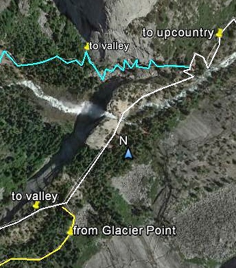
Before reaching the upper falls area is a junction with an important decision:
Go left onto the JOHN MUIR TRAIL and you have a longer but apparently kinder descent to near a junction with the Mist Trail below Vernal Falls, or even further to the valley floor short of Happy Isles.
Go straight ahead and you reach the MIST TRAIL, a considerably shorter but knee/ankle/hip killing, often wet and much more scenic descent alongside the two waterfalls.
 Trail choices above Nevada Falls. The yellow trail is the upper Panorama track. The white one is the John Muir Trail. Blue is the Mist Trail. I came down the yellow trail and chose to descend into the valley via the blue Mist Trail.
A lot of people were doing a shorter loop - up the John Muir from the valley and back down the Mist Trail. People like me with bad knees and high fitness should maybe consider the opposite direction.
Straight line distance between lower "to valley" and "to upcountry" place markers is 760m.
 This great schematic in the village Visitors' Center shows the two options - the Mist Trail at left and the part of the John Muir Trail at right. Note the descent down the John Muir isn't classed by reviewers as easy, but they rate it considerably less trying than the Mist Trail.
Time - 1735. I chose to go staight ahead towards the Mist Trail on account I'm a waterfall fan - even though my beat up knees (too much jogging on hard surfaces back in the days or poor shoes/no shoes) hate tough descents
 This is the bridge across the Merced River above Nevada Falls. I found a lot more people on this section of the track - they had come up the John Muir from the relatively nearby valley and were going back down the Mist. This loop is one of the most popular walks from Yosemite Valley. Note that the above part of the track is actually a continuation of the John Muir as it heads into the mountains.
 This nice pool is just upstream from the bridge. I should have stopped for a splash of water and a rest but it was 1750 and I wanted to get back to my car before dark (fat chance). In high water times more than one poor soul has been swept out of this pool, under the bridge I'm photographing from and....
 ....over the falls. It's a 594ft/181m drop.
 1800: These people are turning down THE MIST TRAIL to begin the descent alongside Nevada Falls. The John Muir Trail continues to the right - stay on it and you will eventually reach Mt Whitney several hundred miles later - Little Yosemite Valley, Half Dome and Tenaya Lake are much closer .
The thing about the Mist Trail is it seems to keep going on and on. Lower down, the steps were maybe not as tough as those pictured below, but they still were extremely taxing on my by this time (abt 9 hrs) fairly used up body (hey, at the date of this walk I was a week off my 70th birthday - so cut me some slack.)
EVEN LESS FUN, MUM!
 The Mist Trail as it descends alongside the two waterfalls is a killer. Quite a lot is similar to the above - extremely steep, rough granite steps. Spacing is uneven - often too close, frequently the step-downs are those large knee/ankle/hip bashing ones; in dry conditions they were slippery with dust (I saw several people fall - would have myself except for my trusty hiking poles which also probably saved my knees. Note in high river flow periods this section is often covered with spray from the falls - and is consequently even more slippery). Pay attention to the trail - don't get distracted by views of the cascading water to the side: stop for those. There are several places you can walk off the trail, drink in the scene and get some nice pix, like....
 ....this spot, part-way down NEVADA FALLS.
I reached the top of VERNAL FALLS (5044ft/538m) at 1853. The opening pic at the top of this page shows the outlook.
 There is a fair bit of telephoto in this shot - it is actually 320ft/98m from camera to pool. Dudes alongside pool had rock-hopped a hundred meters to get there - I was at the base of the falls 20 minutes later - didn't bother abt any rock hopping.
The steep descent continued alongside Vernal Falls and then a bit further down valley, although maybe not quite as bad as the path pictured up-page. In all, the killer trail past the two waterfalls and further is well over a mile and I seemed to be on it for at least an hour. I read somewhere there are over 600 stairs along here. 600 aint the big deal - more important: well over half are rough, high and treacherous.
 Shot from the bottom of Vernal Falls - time 1908. Looks ok at this time of low-flow - would be awesome in spring/early summer.
A little over a mile below the bottom of Vernal Falls I reached the valley floor . The last half had pretty gentle gradients. The lower junction of the John Muir trail is along here. Much of the route below Vernal Falls is well sealed and would be wheelchair suitable. I passed HAPPY ISLES and finally emerged on the CURRY VILLAGE road loop at 1947. I had been going over 10 hours. Shuttle bus stop #16 was a mere 150m to the left and I only had to wait a few minutes for one of the village-route shuttles to appear.
WHICH WAY ON THE WATERFALL LOOP?
90% of people I encountered seemed to come up the John Muir and go down the Mist Trail. I think this is the go for people who are not very very fit and have no knee/hip problems. But please be careful on those slippery treacherous step-downs.
I personally would do it the other way - I reckon the killer climb UP the Mist Trail would fit into my "VERY STEEP" rating (which is below "HEART BREAKER" and "DON'T SEND FLOWERS" categories). If I was fresh I would look at it as a challenge. And my knees would by all accounts find the descent down the John Muir much more friendly.
MY BIG LOOP REVERSED?
Would a reverse of my full walk, starting at the Curry Village end and descending the 4 mile trail, be a better bet?
I'm not sure. I'm thinking for me personally it would be much the same. Certainly the first hour or so would be a bit harder balanced by the last few km not bashing me about as much.
THE BIG LOOP SUMMED UP.
I did my extra training for the big Grand Canyon trek, but if that was a 10 effort-wise, the Yosemite Big Loop was a 12. I finished the Grand Canyon feeling pretty good - the Big Loop a bit second hand.
But the value of extra training is how you bounce back - next day I had no aches and pains and felt pretty fresh. Just as well - on my dance card I had penciled in some Yosemite Falls treks plus getting to my San Francisco digs before dark.
Well I almost did it.
BACK TO THE RENTAL
This didn't work out as planned. I arrived at the valley bottom too late to get the El Capitan shuttle bus which stops running at 1800 (memo to self - read the fine print). The village shuttle dropped me as close as possible to the 4 Mile trailhead car park - at stop #7. Following was about a km hike across valley to Southside Drive and a short walk down the road.
It was pretty dark this moonless night heading across the valley trail - I began thinking about Black Bears. But there were a few people out riding bicycles and walking with torches. Besides which, why would a veteran from the land of the world's most poisonous snakes and spiders, ferocious car-sized wild pigs, man-eating crocs, baby-stealing wild dogs and sex-crazed Drop Bears** worry about Black Bears? They aint exactly Grizzlies.
By the time I got back to my car, drove the hour+ to Yosemite Bug resort, showered and cooked/downed some tucker it was past 2300. Once again I had the delightful experience of hauling myself into my dorm top bunk in the dark. At least I didn't have to make it up from scratch like the night before.
**Drop Bears are a branch of the Koala family. They think it's top sport to drop from their favourite eucalyptus trees onto the heads of unsuspecting passers-by. Which they en-wrap in a kind of ..um..bear hug. They are randy little buggers and like to dry hump any vacant ear holes.
 Bloke at left is C Dundee's mate Strop. Strop's slightly shell-shocked appearance is down to his north coast NSW hobby farm being over-run with Drop Bears - poor dude is suffering severe brain bonk.
Actually ol' Strop is a bit of a worry - all that melon-trauma has seriously impacted his equilibrium - the farm runs sheep and Stop is always talking about his girlfriend Baa Baa Raa.
And you thought New Zillund** has a monopoly on sheep-shaggers. Our fush and chups eating cousins from THE LAND OF THE MURDERED VOWEL can't even corner the market in good rugby teams these days.
(image Adelaide Advertiser)
**Ah beyoodiful New Zillund.
Where men are men. And the sheep run scared.
WORD EATING DEPARTMENT 31 Oct 2015 - I wrote the above about 3 weeks ago. But New Zillund has just won the RUGBY WORLD CUP which of course makes them best in the world.
Can't get any better than that.
That strange noise you recently heard was 43 million Kiwi sheep breathing a collective sigh of relief (New Zillunders aren't good losers).
DAY 2
Any trekking day 2 had to be a lot shorter than THE BIG LOOP on account I wanted to check the VISITORS CENTER in Yosemite Village and hoped to make my accommodation in San Francisco before dark.
The full UPPER FALLS TRAIL would be too time consuming but going half way to the first view of the upper falls sounded appealing - reports said there was a fair bit of uphill stuff which would give me a good workout, but the first viewpoint was short of the killer steps on the upper part of the upper falls trail which I needed to avoid considering the previous day's bashing on the MIST TRAIL descent.
And I figured I had time to do the nearby short circuit to the lower falls.
 Modified Google Earth image shows both 2nd day treks. Lower right we have the easy Lower Falls loop. To the left is the part of the Upper Falls track I did to the first view of the upper falls. Straight line distance from the car park place mark to the upper falls place mark is 1.65km - just over a mile. But if you want to walk up to the viewpoint just above and to the right of the falls you are looking at 6km/3.8miles. The vertical difference is 780m/2560ft.
 Nice schematic from Visitors' Center gives a different perspective of both trails. Upper Falls track begins bottom far left - ends top right for people with time and ability to get there.
I parked in the big village parking area - lotsa traffic coming in early this Sunday in August, but the lot was less than 20% full at around 0930. The lot is only 600m from the visitors' center but there was a waiting free shuttle so I jumped aboard - time was at a kind of premium.
 I'm not a big fan of visitors' centers/location museums etc - but I enjoyed my wander around Yosemite Valley Visitors' Center. There was lots of stuff on how the valley was shaped by the old time glaciers, several terrific schematics (as featured on this page) showing the main hiking trails and.....
 ....no shortage of stuff on the original inhabitants of the valley.
Note that in this general area there is a pretty good general store - deli-coffee shop, a NP information booth, US post office, museum and art gallery. A bit further gets you to an ATM, a bigger general store and an accommodation booking place.
LOWER YOSEMITE FALLS
This is one of the shortest, easiest and most popular treks in the valley. It is close to Yosemite Village and on the way to the nearby Upper Falls trailhead.
 Section of excellent schematic in the Visitors' Center shows the layout of the loop track. It is fairly flat, sealed/wheelchair accessible (National Parks says right (western) half only but they are probably taking into account people with upper body problems - the east track slopes seemed pretty benign) and short at 0.5 miles/0.8km.
There is no car park but it's less than a mile (1.6km) from the village. Once again I found one of the free shuttles waiting and saved myself a bit of time.
Check the Valley Loop Trail left of image - 0.6mi/1km of pleasant forest walk got me across to the Upper Falls trailhead.
 Another perspective of the Lower Falls loop trail - this one from a display board at the trail head.
OOPS. NO WATER
 Most years see no or little water in September/October but California's drought meant the falls were dry in mid August.
 This one from the National Park's hiking website shows a better flow.
 I got the impression that a lot of this area between the two sides of the loop trail would have flowing rivulets of water and some standing ponds most times of the year.
LOWER FALLS LOOP SUM UP
If my big Grand Canyon trek the week before was a 10, my previous day's Yosemite Big Loop a 12, I'm calling the Lower Falls Loop a 1. No problems for anyone. Wheelchair people and Big Bob from Biloxi might find going anticlockwise on the loop best to hit the steepest part downhill (um ---fer those tragics can only tell the time on a digital watch or 'phone we are talking right hand (eastern) side of the loop first).
UPPER YOSEMITE FALLS TRAIL
On this second day I wanted something to give me a good workout - but maybe for only 4 or 5 hours return. My research told me that going half way along the Upper Falls Trail would do the job. I wasn't too upset about not going the full distance. The falls were dry, the smokey conditions would have diminished the views from the top which apparently are almost as good as from Glacier Point but from the opposite side of the valley, and my reading of the steep switchbacks on the higher part of the trail suggested they were in the same category as the Mist Trail: I reckon my knees may not have been able to handle another work-out on the descent.

 My walk is outlined in yellow on the upper image but is best followed if you click-expand the lower cropped schematic featured in the Yosemite Visitors Center.
The full trail up to the falls overlook is a 7.6miles/12km round trip gaining some 2559ft/780m - my truncated walk was 3 miles/4.8km return gaining just over 1000ft/300m
The trail begins at the car park for camp #4 alongside the main Northside Drive. At busy times it may be better to park in one of the big Yosemite Village lots and catch a frequent free shuttle the short distance to stop #7. I walked the flat pleasant 600m path thru the forest from the Lower Falls loop.
Soon after leaving the car park, the Upper Falls trail begins to climb. Gradients are moderately steep, a bit more so than say the 4 Mile Trail, and there is a series of switchbacks which seem to go on for ever. My mate Kananga would be underwhelmed. The condition of the trail was a bit rough without becoming unpleasant - plenty of step-ups (dreaded step downs in the opposite direction of course), some with quite big vertical differences (these are the knee killers on descents) but fortunately there were few cases where the step up/downs were extremely close together unlike the Mist Trail. Even better, I can't remember any staircases. However there were some tree roots in places and quite a few of the stairs were slippery with dust - I'm glad I had my trekking poles although I didn't see anyone fall. At least 50% of the distance was tree-shaded. This trail seemed popular - more so than the previous day's 4 Mile (but that was somewhat earlier in the day).
 You don't have to head too far up the trail before the good views become apparent. I reckon I'm abt 500ft/160m above the valley floor here. Sorry abt the smoke - I've mentioned before the impact of the big forest fires in the south west Sierras.
I'm thinking that's SENTINEL ROCK highest mid image, SENTINEL DOME is the higher point (although it looks abt equal from this aspect on account it is further from the camera) just to its left, and the famous GLACIER POINT is the area slightly lower far left. If you disagree, please post in below.
 There are nice valley floor view along here. I think that is YOSEMITE LODGE - please post in if I'm wrong.
 Higher again. Columbia Rock - distance from trailhead 1.0 miles/1.6km, At 5036ft/1535m it's just over 1000ft/300m above the valley floor . As such the views are more expansive again. Here we are looking almost due east - that's HALF DOME upper center image. GLACIER POINT is at right. YOSEMITE VILLAGE is mid left of shot. I reached this point at 1319 - abt an hour 20 after leaving the valley floor. That's not even 1mph/1.6kph - good grief, I mentioned before I'm no Speedy Gonzales, but maybe the previous day's BIG LOOP impacted me more than I thought.
But who cares? I was feeling good and powered on to FIRST VIEW.
Soon after leaving Columbia Rock the trail gets more difficult - but thankfully only for a short distance. It both steepens into what I would classify as QUITE STEEP (but considerably below my "HEARTBREAKER" category) and gets more sandy underfoot. I read somewhere that this is a land-slip area. Fortunately the really steep section is little over 400m in length. Shortly after the trail flattens, turns a corner to head directly north and starts dropping - maybe 200ft/65m in 5 minutes. When it flattens out you should start looking across the narrow side-canyon for the Upper Fall - I missed it completely on account of no water/no noise and the fact that it drops midway along the canyon wall rather than further north at the gulley-head where you would expect a waterfall to be. So I had to backtrack several hundred meters to the point of first view. I believe this general area is known as FIRST GATE. It took me about 15 minutes to get from Columbia Rock to first view.
 First view in mid August 2015 was not all that impressive - absolutely no water coming over the falls. So I went online looking for something more normal.......
 .....and found this nice one on the National Park website, shot more or less from the same position. Note National Park informs that you may meet conditions similar to mine often in the area's driest period - September and October.
Going back down was not too bad at all despite the relatively steep, sometimes slippery and multi-stepped conditions. I think I might have been subconsciously thinking of the want to be in 'Frisco before dark because it took only an hour. Still that's only abt 1.7mph/2.8kmh. I arrived back at the trailhead at 1450.
FOR PEOPLE WHO ARE INTERESTED - ONWARD TO THE UPPER FALLS
It's another 2.8 miles/4.4km with a vertical rise of 1600ft/490m to the Yosemite Falls overlook.
 From what I have read, much of it is very steep with multi-switchbacks and often slippery conditions. Shade is lacking for much of the way.
The outlook over the valley is apparently a bit restricted at the falls overlook - no worries, it's only another 0.75 miles/1.2km to the even higher YOSEMITE POINT (6936ft/2114m v 6526/1989) - out of view to the right of the above image - where....
 .....the oulook is apparently outstanding in good conditions (this is another image taken from the National Park's hiking website)
UPPER FALLS TO FIRST VIEWPOINT SUM UP
I notice that I went a fair bit short of half-way. Nevertheless I thought it was a pretty good work out although less than 3 hours return is chicken-manure compared to my 10 hour Big Loop on the previous day.
Compared to the Big Loop's 12, I'm giving this one a 6.
How would I have gone without the extra preparation I did? I reckon this trek was no harder than many I have done in the Thai Islands. Certainly the latter have way steeper, rougher, more treacherous trails. I've never had problems on any of them in my pre training for the Grand Canyon days.
That answers the question about how a fairly fit person would go.
How would a normal person (fairly unfit) go? I reckon they would be able to do this walk, but would need to take a fair few stops.
How would an definitely unfit person go? Fergeddaboudit. If my svelte-challenged mate Kananga took off on this one he would be hoping his babe, the sensationally scintillating Siam Soonay** remembered to throw the PORTAZAPPA (Mk11) into her backpack.
 I'm thinking if I had to follow Soonay up the Yosemite Falls Track I'd be soon needing the PORTAZAPPA (Mk11) too.
**Soonay is a dancer/sharp-shooter at Bangkok's Ballistic Banana Club. She is so toned she has muscles on her ---- -----. No problems for Soonay galloping up the Upper Falls Trail.
IF YOU SEE MISTAKES OR HAVE ADDITIONAL INFO PLEASE MENTION THEM BELOW - BUT PLEASE DIRECT ANY QUESTIONS TO THE FORUM SECTION - I DON'T LOOK AT THESE INDIVIDUAL PAGES VERY OFTEN BUT I CHECK THE FORUM MOST DAYS.

(image Pittsburgh Post-Gazette)
THE BIG LOOP - 4 MILE TRAIL/SENTINEL DOME SIDE TRACK/PANORAMA TRAIL

Vernal Falls on the Mist Trail section of the Panorama Trail
My BIG LOOP involves the following: 4 Mile Trail from valley floor to Glacier Point - side trail to Sentintel Dome - Panorama Trail back to valley floor.
GLACIER POINT is one of the most visited viewpoints in Yosemite. I didn't fancy the 30mile/49km drive from the village but the hike up the 4 Mile track sounded okay - particularly when I read there are some great and unique outlooks along the way.
And having reached Glacier Point, I'd be a mug not going a bit higher to SENTINEL DOME. Accounts say the extra height gives views even better than Glacier Point.
But then I'd have to get back to the valley. Didn't have a partner to drive me down and apparently it is real hard to score a vacant seat on one of the buses which do the trip. I didn't want to backtrack down the 4 Mile. Then I read up about the really long Panorama Trail which includes the popular Mist Trail with its views of NEVADA and VERNAL FALLS.

4 Mile Trail in white, side trail to Sentinel Dome in yellow, Panorama Trail in blue.
This is a loong walk at 16.4miles/26.2km. Fair bit of climbing/descending too. The valley floor at the start is 4000ft/1120m above sea level. Highest point is at Sentinel Dome - 8127ft/2477m, meaning lowest to highest is a difference of 4127ft/1258m.
Getting back from the end of the Panorama to my rental at the start of the 4 Mile seemed easy - use the free valley shuttle buses which run around the valley floor. Didn't quite work out that easy.

COMPARISON WITH MY GRAND CANYON TREK
My Grand Canyon epic less than a week before was not exactly a stroll in the park, but the Canyon stroll was actually shorter (23km v26), had a lower highest point (7200ft v 8127), less verticality (3100ft v 4127) and a shorter duration (9 hours v 10).
You are probably not surprised to know the Big Loop left me feeling considerably more used up than after the Grand Canyon thing. But it wasn't the distances or uphill slogs - one main factor whacked me around more; the killer descent on the Mist Trail. More later.
PREPARATION
I'm a seriously old dude but very very fit. However I knew the distances, slopes and heights involved both at the Canyon and in Yosemite required extra preparation. Check the link above to see what I did. It didn't hurt that after the Grand Canyon I had done a trek to LONE PINE LAKE, about a quarter of the way up the MOUNT WHITNEY TRAIL (and as far as you are allowed to go without a permit). This was only a little over 4 hours return but involved higher altitudes again (the lake is at 10500ft after a 8300ft start and is thus good for altitude acclimatization).

Lone Pine Lake with Mt Whitney behind. Picture pretty smokey due to big fires in the south-east Sierras. Also made Yosemite views less clear the next day. This is a nice shot to click-expand.
I also had my hiking poles, good trekking shoes and socks, trail mix/power bars and electrolyte. I carried less water than in the Canyon. Not only were temps lower but water is available at Glacier Point, so I figured 1L was enough for the 4 Mile Trail (water available at the top) and 2 would get me back down the Panorama.
THE 4 MILE TRAIL
4.7miles/7.5km 4000ft/2200m to 7200ft/2200m for a 3200ft/approx1000m climb


I hit the trail at 0947 after a false 0930 start - I left my hiking poles leaning against the front fender - DUH!
The first 5 minutes of the trail are along the valley flat. When the climb begins the slopes are pretty moderate and seldom get steeper the whole way. There is no section I'd class as steep although less fit dudes like my circumferrentialy-enhanced internet friend Kananga (the only man [still alive**] who can hoover a 12inch/300mm coconut-cream pie in under 35 seconds) may disagree.
**might have something to do with his sensational squeeze - the super sensual Siam Soonay who is the CPR champion of central Kranji - as I pointed out on the Grand Canyon page, this scintillating sweetheart has given the kiss of life almost as often as a pash of passion.
The surface of the lower trail and some of the upper-most section is badly broken bitumen - may have been sealed to assist wheelchairs but even when in good condition the slopes would demand an Olympic-class wheelchair athlete or a big super-fit pusher (put that wheelchair away Kananga - Soonay aint a big dude). The broken/discontinuous surface now makes it impossible for wheelchairs. Skaters should shelve any plans of fanging down-hill - check "discontinous" above. At the same time this surface is not a difficult one to walk - ditto unsealed central areas of the track which are relatively smooth underfoot. Shaded by trees and cliffs over 50% of the way. There were few stairs, mainly single. A moderate number of trekkers heading up, but not crowded. Few descending - may be more later in day.


I pinched this off the National Park treks site linked up page - shows what it can be like.

Glacier Point was quite crowded - on account of the carpark only 200m away. Check the smoke.
There is a cafeteria and gift shop up here. WCs of course plus a spot to refill water bottles - covered by bees when I called by. Not for long.

I would be finishing my big trek near far right of frame about 7 hours later.


4 MILE TRAIL SUM UP
I was feeling so good at the top of the trail I could have gone a posse of pole-dancers without raising my pulse. On reflection, a bunch of hot ones would blip it up a beat or two. Okay, I'll come clean - the old ticker would be beating so hard it would blitz the sensors on my Fitbit. Send for Nurse Betty!

Um, sorry about that - got carried away.
Although it gives me some ideas for my upcoming birthday bash.
POLE DANCER IMAGE REMOVED ON DIRECTION OF GOOGLE - CRIKEY, WHAT IS THIS WORLD COMING TO WHEN READER WOWSERS DICTATE WHAT WE POST AND VIEW?
image pinterest.com
Although fantasy above is maybe a bit in front of reality below....

image Baltimore Sun
**maybe it wasn't such a good idea to short the Euro. But when are people going to wake up that the 'Tuero' as we know it now will not exist in the not too distant future?
Could a fit person do the 4 Mile without my extra work-outs? Easy.
Could a person of normal fitness (which these days is pretty unfit) do it? I think so, but lots of stops would be needed and they might suffer next day.
Could a Kananga do it? No chance. The circumferencially enhanced Kranji Kid has 2 rest stops and a defibrillator station on the 5 steps up to his preferred Prue's Parisian Patisserie on the Payoh promenade.
THE REVERSE TRIP - quite a few people ride up and walk down. I reckon even unfit people could manage this (maybe not the grossly unfit). It is not so steep and rough that it is a knee-wrecker so most people should have few problems with this. But cut those toe nails - even ordinary length toe nails can get miserably sore banging up against the front of shoes on prolonged downslopes.
SIDE TRAIL TO SENTINEL DOME
This is a relatively short one at abt 1.6miles/2.6km one-way from Glacier Point. Height gained is 927ft/almost 300m.
For car carried crazies a shorter path leads in from a Glacier Point Road car park which is a good 7miles/12km from the Glacier Point car park (and abt 13miles/22km from the start of Glacier Point Rd which in itself is quite a long way from Yosemite Village). The walk in is pretty flat except for the final haul up the side of the dome.

I found the track between Glacier Point and Sentinel Dome not too rough and of similar steepness to the 4 Mile Trail. However the penultimate 400m steepened, moving out of my "moderate" into "fairly steep" category. And....


SIDE TRAIL SUM UP
The short distance up from Glacier Point will not trouble fit people. The average person may be less than gruntled by the last 600m. Really unfit people will not like it at all. They will find the walk in from Glacier Point Rd car park much more to their liking although they still have to haul themselves up the side of the Dome.
Me personally?....it may be because I didn't really stop to rest at Glacier Point, but when I got to the top of the Dome I was starting to feel a bit used up. I was glad I was as at the top of my trek and could look forward to all-downhill from then on. Hur hur hur - that's what I thought.
THE PANORAMA TRAIL
Distance - 8.5miles/13.5km vertical change - 3200ft/975m

Tilted Google Earth image is misleading - the constant downhill from Glacier Point to Illiloette Falls (top left) doesn't look downhill all the way. Similarily, the uphill section to the left of Illiloette Falls doesn't come out very well. I was underwhelmed with this uphill.
In this image you are looking just slightly west of due south.

I started the descent from Glacier Point at 1316 after taking on some trail mix, energy bars and electrolyte plus adding an extra liter of water to my supply.
The approx 1400ft/420m descent to Illiloette Falls is slightly over 2 miles/3.2km and is a doddle - the path slopes reasonably gently and has a good surface. The last few hundred meters steepens but is no problem. There are more or less continuous valley, south face and waterfall views along here. There is one trail branch near the falls but the correct route is clearly signposted.


NO FUN MUM - heading on from Illiloette Falls the track does a sneaky trick. It starts to head uphill! Now I'm no stranger to uphill stetches on a descending track, but usually they are short duration. Bu no - initially via a set of switchbacks, the climb is almost a mile/kilometer and a half, gaining some 800ft/250m. I was not amused. The slope wasn't a killer at about equal to the 4 Mile Trail but at its start I had been on my feet for 6 1/2 hours, much of it uphill and was beginning to feel a little second hand. The climb seemed to go on forever - actually about 25 minutes.
One nice point - about half a mile on from Illiloette Falls is a short-unsignposted side track which goes about 100m to PANORAMA POINT. This reportedly has some of the best views of the whole trail - it is unsignposted because a landslide took the viewpoint's safety rails and National Parks thinks it may not be such a good idea to encourage visitors.
I took a few pix but the smoky conditions seemed extra bad here (maybe it was the angle of the late afternoon sun) making for mediocre results.


At the top of the climb I was back to about 6600ft/2000m. The trail levels out here for approx a km and then starts to drop over a similar distance to the top of NEVADA FALLS which is abt 5900ft/1800m above sea level.
Before reaching the upper falls area is a junction with an important decision:
Go left onto the JOHN MUIR TRAIL and you have a longer but apparently kinder descent to near a junction with the Mist Trail below Vernal Falls, or even further to the valley floor short of Happy Isles.
Go straight ahead and you reach the MIST TRAIL, a considerably shorter but knee/ankle/hip killing, often wet and much more scenic descent alongside the two waterfalls.
A lot of people were doing a shorter loop - up the John Muir from the valley and back down the Mist Trail. People like me with bad knees and high fitness should maybe consider the opposite direction.
Straight line distance between lower "to valley" and "to upcountry" place markers is 760m.

Time - 1735. I chose to go staight ahead towards the Mist Trail on account I'm a waterfall fan - even though my beat up knees (too much jogging on hard surfaces back in the days or poor shoes/no shoes) hate tough descents


The thing about the Mist Trail is it seems to keep going on and on. Lower down, the steps were maybe not as tough as those pictured below, but they still were extremely taxing on my by this time (abt 9 hrs) fairly used up body (hey, at the date of this walk I was a week off my 70th birthday - so cut me some slack.)
EVEN LESS FUN, MUM!


I reached the top of VERNAL FALLS (5044ft/538m) at 1853. The opening pic at the top of this page shows the outlook.

The steep descent continued alongside Vernal Falls and then a bit further down valley, although maybe not quite as bad as the path pictured up-page. In all, the killer trail past the two waterfalls and further is well over a mile and I seemed to be on it for at least an hour. I read somewhere there are over 600 stairs along here. 600 aint the big deal - more important: well over half are rough, high and treacherous.

A little over a mile below the bottom of Vernal Falls I reached the valley floor . The last half had pretty gentle gradients. The lower junction of the John Muir trail is along here. Much of the route below Vernal Falls is well sealed and would be wheelchair suitable. I passed HAPPY ISLES and finally emerged on the CURRY VILLAGE road loop at 1947. I had been going over 10 hours. Shuttle bus stop #16 was a mere 150m to the left and I only had to wait a few minutes for one of the village-route shuttles to appear.
WHICH WAY ON THE WATERFALL LOOP?
90% of people I encountered seemed to come up the John Muir and go down the Mist Trail. I think this is the go for people who are not very very fit and have no knee/hip problems. But please be careful on those slippery treacherous step-downs.
I personally would do it the other way - I reckon the killer climb UP the Mist Trail would fit into my "VERY STEEP" rating (which is below "HEART BREAKER" and "DON'T SEND FLOWERS" categories). If I was fresh I would look at it as a challenge. And my knees would by all accounts find the descent down the John Muir much more friendly.
MY BIG LOOP REVERSED?
Would a reverse of my full walk, starting at the Curry Village end and descending the 4 mile trail, be a better bet?
I'm not sure. I'm thinking for me personally it would be much the same. Certainly the first hour or so would be a bit harder balanced by the last few km not bashing me about as much.
THE BIG LOOP SUMMED UP.
I did my extra training for the big Grand Canyon trek, but if that was a 10 effort-wise, the Yosemite Big Loop was a 12. I finished the Grand Canyon feeling pretty good - the Big Loop a bit second hand.
But the value of extra training is how you bounce back - next day I had no aches and pains and felt pretty fresh. Just as well - on my dance card I had penciled in some Yosemite Falls treks plus getting to my San Francisco digs before dark.
Well I almost did it.
BACK TO THE RENTAL
This didn't work out as planned. I arrived at the valley bottom too late to get the El Capitan shuttle bus which stops running at 1800 (memo to self - read the fine print). The village shuttle dropped me as close as possible to the 4 Mile trailhead car park - at stop #7. Following was about a km hike across valley to Southside Drive and a short walk down the road.
It was pretty dark this moonless night heading across the valley trail - I began thinking about Black Bears. But there were a few people out riding bicycles and walking with torches. Besides which, why would a veteran from the land of the world's most poisonous snakes and spiders, ferocious car-sized wild pigs, man-eating crocs, baby-stealing wild dogs and sex-crazed Drop Bears** worry about Black Bears? They aint exactly Grizzlies.
By the time I got back to my car, drove the hour+ to Yosemite Bug resort, showered and cooked/downed some tucker it was past 2300. Once again I had the delightful experience of hauling myself into my dorm top bunk in the dark. At least I didn't have to make it up from scratch like the night before.
**Drop Bears are a branch of the Koala family. They think it's top sport to drop from their favourite eucalyptus trees onto the heads of unsuspecting passers-by. Which they en-wrap in a kind of ..um..bear hug. They are randy little buggers and like to dry hump any vacant ear holes.

Actually ol' Strop is a bit of a worry - all that melon-trauma has seriously impacted his equilibrium - the farm runs sheep and Stop is always talking about his girlfriend Baa Baa Raa.
And you thought New Zillund** has a monopoly on sheep-shaggers. Our fush and chups eating cousins from THE LAND OF THE MURDERED VOWEL can't even corner the market in good rugby teams these days.
(image Adelaide Advertiser)
**Ah beyoodiful New Zillund.
Where men are men. And the sheep run scared.
WORD EATING DEPARTMENT 31 Oct 2015 - I wrote the above about 3 weeks ago. But New Zillund has just won the RUGBY WORLD CUP which of course makes them best in the world.
Can't get any better than that.
That strange noise you recently heard was 43 million Kiwi sheep breathing a collective sigh of relief (New Zillunders aren't good losers).
DAY 2
Any trekking day 2 had to be a lot shorter than THE BIG LOOP on account I wanted to check the VISITORS CENTER in Yosemite Village and hoped to make my accommodation in San Francisco before dark.
The full UPPER FALLS TRAIL would be too time consuming but going half way to the first view of the upper falls sounded appealing - reports said there was a fair bit of uphill stuff which would give me a good workout, but the first viewpoint was short of the killer steps on the upper part of the upper falls trail which I needed to avoid considering the previous day's bashing on the MIST TRAIL descent.
And I figured I had time to do the nearby short circuit to the lower falls.


I parked in the big village parking area - lotsa traffic coming in early this Sunday in August, but the lot was less than 20% full at around 0930. The lot is only 600m from the visitors' center but there was a waiting free shuttle so I jumped aboard - time was at a kind of premium.


Note that in this general area there is a pretty good general store - deli-coffee shop, a NP information booth, US post office, museum and art gallery. A bit further gets you to an ATM, a bigger general store and an accommodation booking place.
LOWER YOSEMITE FALLS
This is one of the shortest, easiest and most popular treks in the valley. It is close to Yosemite Village and on the way to the nearby Upper Falls trailhead.

There is no car park but it's less than a mile (1.6km) from the village. Once again I found one of the free shuttles waiting and saved myself a bit of time.
Check the Valley Loop Trail left of image - 0.6mi/1km of pleasant forest walk got me across to the Upper Falls trailhead.

OOPS. NO WATER


LOWER FALLS LOOP SUM UP
If my big Grand Canyon trek the week before was a 10, my previous day's Yosemite Big Loop a 12, I'm calling the Lower Falls Loop a 1. No problems for anyone. Wheelchair people and Big Bob from Biloxi might find going anticlockwise on the loop best to hit the steepest part downhill (um ---fer those tragics can only tell the time on a digital watch or 'phone we are talking right hand (eastern) side of the loop first).
UPPER YOSEMITE FALLS TRAIL
On this second day I wanted something to give me a good workout - but maybe for only 4 or 5 hours return. My research told me that going half way along the Upper Falls Trail would do the job. I wasn't too upset about not going the full distance. The falls were dry, the smokey conditions would have diminished the views from the top which apparently are almost as good as from Glacier Point but from the opposite side of the valley, and my reading of the steep switchbacks on the higher part of the trail suggested they were in the same category as the Mist Trail: I reckon my knees may not have been able to handle another work-out on the descent.


The full trail up to the falls overlook is a 7.6miles/12km round trip gaining some 2559ft/780m - my truncated walk was 3 miles/4.8km return gaining just over 1000ft/300m
The trail begins at the car park for camp #4 alongside the main Northside Drive. At busy times it may be better to park in one of the big Yosemite Village lots and catch a frequent free shuttle the short distance to stop #7. I walked the flat pleasant 600m path thru the forest from the Lower Falls loop.
Soon after leaving the car park, the Upper Falls trail begins to climb. Gradients are moderately steep, a bit more so than say the 4 Mile Trail, and there is a series of switchbacks which seem to go on for ever. My mate Kananga would be underwhelmed. The condition of the trail was a bit rough without becoming unpleasant - plenty of step-ups (dreaded step downs in the opposite direction of course), some with quite big vertical differences (these are the knee killers on descents) but fortunately there were few cases where the step up/downs were extremely close together unlike the Mist Trail. Even better, I can't remember any staircases. However there were some tree roots in places and quite a few of the stairs were slippery with dust - I'm glad I had my trekking poles although I didn't see anyone fall. At least 50% of the distance was tree-shaded. This trail seemed popular - more so than the previous day's 4 Mile (but that was somewhat earlier in the day).

I'm thinking that's SENTINEL ROCK highest mid image, SENTINEL DOME is the higher point (although it looks abt equal from this aspect on account it is further from the camera) just to its left, and the famous GLACIER POINT is the area slightly lower far left. If you disagree, please post in below.


But who cares? I was feeling good and powered on to FIRST VIEW.
Soon after leaving Columbia Rock the trail gets more difficult - but thankfully only for a short distance. It both steepens into what I would classify as QUITE STEEP (but considerably below my "HEARTBREAKER" category) and gets more sandy underfoot. I read somewhere that this is a land-slip area. Fortunately the really steep section is little over 400m in length. Shortly after the trail flattens, turns a corner to head directly north and starts dropping - maybe 200ft/65m in 5 minutes. When it flattens out you should start looking across the narrow side-canyon for the Upper Fall - I missed it completely on account of no water/no noise and the fact that it drops midway along the canyon wall rather than further north at the gulley-head where you would expect a waterfall to be. So I had to backtrack several hundred meters to the point of first view. I believe this general area is known as FIRST GATE. It took me about 15 minutes to get from Columbia Rock to first view.


Going back down was not too bad at all despite the relatively steep, sometimes slippery and multi-stepped conditions. I think I might have been subconsciously thinking of the want to be in 'Frisco before dark because it took only an hour. Still that's only abt 1.7mph/2.8kmh. I arrived back at the trailhead at 1450.
FOR PEOPLE WHO ARE INTERESTED - ONWARD TO THE UPPER FALLS
It's another 2.8 miles/4.4km with a vertical rise of 1600ft/490m to the Yosemite Falls overlook.

The outlook over the valley is apparently a bit restricted at the falls overlook - no worries, it's only another 0.75 miles/1.2km to the even higher YOSEMITE POINT (6936ft/2114m v 6526/1989) - out of view to the right of the above image - where....

UPPER FALLS TO FIRST VIEWPOINT SUM UP
I notice that I went a fair bit short of half-way. Nevertheless I thought it was a pretty good work out although less than 3 hours return is chicken-manure compared to my 10 hour Big Loop on the previous day.
Compared to the Big Loop's 12, I'm giving this one a 6.
How would I have gone without the extra preparation I did? I reckon this trek was no harder than many I have done in the Thai Islands. Certainly the latter have way steeper, rougher, more treacherous trails. I've never had problems on any of them in my pre training for the Grand Canyon days.
That answers the question about how a fairly fit person would go.
How would a normal person (fairly unfit) go? I reckon they would be able to do this walk, but would need to take a fair few stops.
How would an definitely unfit person go? Fergeddaboudit. If my svelte-challenged mate Kananga took off on this one he would be hoping his babe, the sensationally scintillating Siam Soonay** remembered to throw the PORTAZAPPA (Mk11) into her backpack.

**Soonay is a dancer/sharp-shooter at Bangkok's Ballistic Banana Club. She is so toned she has muscles on her ---- -----. No problems for Soonay galloping up the Upper Falls Trail.
IF YOU SEE MISTAKES OR HAVE ADDITIONAL INFO PLEASE MENTION THEM BELOW - BUT PLEASE DIRECT ANY QUESTIONS TO THE FORUM SECTION - I DON'T LOOK AT THESE INDIVIDUAL PAGES VERY OFTEN BUT I CHECK THE FORUM MOST DAYS.


6 comments:
We are a thailandcosmeticcenter.com Wholesale Suppliers Distributors & Overstocks and Customer Returns. thailandcosmeticcenter.com has been helping customers and companies of all sizes since it was first founded. We know how difficult and confusing it can be to do business in this particular industry. Our sales team has a vast network of sources including manufacturers and retailers, which can offer you the widest varieties of wholesale closeout merchandise at the lowest possible cost. Helping you maximize your investment. Here are options for the Wholesale Cosmetics, Thailand Cosmetics, مستحضرات التجميل, factory voox Thailand and Voox dd cream or Voox dd Soap.
You might wanna check this new destination called cayo santa maria at cayo-santamaria.com this is a beautiful beach resort!
Sensible zoning for that corner, but oh so close to the holy, untouchable two blocks of Empire!
browser
have read many blogs in the net but have never come across such a well written blog. Good work keep it up
PADI IDC Gili Islands 2013
Best packers and movers in Faridabad, household shifting service in Faridabad, home relocation in Faridabad, car carriers service in Faridabad, car transport in Faridabad. packers and movers Faridabad
I definitely appreciate your blog. Excellent work!
Bay of Plenty
Post a Comment