VISITED APRIL 2016
ATTENTION - THIS IS A LENGTHY PAGE. IF YOU HAVE BEEN DIRECTED HERE by GOOGLE OR SOME OTHER SEARCH ENGINE, YOU MAY SAVE TIME FINDING YOUR PLACE OF INTEREST AS FOLLOWS:
- DIAMOND HEAD is IMMEDIATELY BELOW
- KOKO CRATER AND RIDGE CLIMB is 22% down page.
- MAKAPU'U HEAD is 45% down page
- LANIKAI PILLBOXES 65%
Not sure how those percentages will work on your device - but the above gives you some idea.
DIAMOND HEAD CRATER
DIAMOND HEAD from WAIKIKI BEACH
DIAMOND HEAD is on the south coast of OAHU, HAWAII'S major island, about 2.5mi/4km by road from central WAIKIKI.
MISTAKE ABOVE - when marking this map I've put the WAIKIKI place marker too far west - that is actually the location of the AIRPORT as can be seen below. WAIKIKI below is in the right place - some 5miles/8km SSE of the airport and much closer to DIAMOND HEAD than shown above.
The above HONOLULU place marker IS ALSO MISLEADING. Greater Honolulu is a fairly big city and extends across much of the southern coast in this image, with offshoots going up mountain ridges and the gullies between - WAIKIKI and DIAMOND HEAD are actually parts of HONOLULU. The natural place to put a HONOLULU place marker is in the DOWNTOWN/CITY/CBD AREA which is between the first "W" and"a" in "Waikiki" above. I have it way too far west - just east of PEARL HARBOUR entrance.
My apologies - as a map maker I'm a great retired economist. On account it's too time consuming to change all these maps the errors continue for the next 7 maps - HALEIWA has the first island map with no mistakes.
CORRECTED WAIKIKI-HONOLULU CBD MAP
No linear scale - the straight line distance between the Pearl Harbour and DIAMOND HEAD place markers is 11.5miles/18.4km.
CLOSE-UP OF DIAMOND HEAD CRATER AND SURROUNDS
The coastal road to the south of the crater is DIAMOND HEAD ROAD which wraps around the eastern and northern sides and becomes MONSARAT AVE not far from its notation on the image (which may be clearer if you click-expand).
The park area to the left (west) alongside the coast is KAPIOLANI PARK. The WAIKIKI HOTEL ZONE is out of image just past the north end of the park.
Area under "V" of "Viewpoint" contains 2 pedestrian tunnels and several steep sets of stairs.
I caught a bus up from WAIKIKI (several routes pass the stop shown - see THE BUS website) and walked the side road to the car park on the crater floor (1100yards/1000m). I then took the path up to the south rim VIEWPOINT (details down page).
I found a long wait for a bus on return - a local advised me to walk 200m west to the next stop where bus #2 picks up every 10/15 minutes.
IN THE CRATER
The crater floor a short distance after entering via the tunnel under the northern rim.
Southern rim in background - viewing platform at highest point.
Last entrance 16.30.
Crater floor from the southern rim observation area. ENTRANCE TUNNEL highlighted by yellow arrow - abt 250m long, not too claustrophobic if you walk thru like me. Side path separates walkers from traffic. As you can see the north rim is considerably lower than the south.
Parking area central, had a lot of daytrip vans and buses, waiting taxis plus many rental cars. $5 per car: S1 for walk-ins like me.
The buildings adjacent the parking area house State Park administrative areas and the gift shop/interpretive kiosk. There are also rest rooms in this area.
Lower slopes of walking track to the southern rim observation deck (partial arrow top-center). Track starts adjacent carpark and is about 1km/1100yard long. Officially classified as a MODERATE trek, I found it varied. The above early section (30%) was a bit of a doddle - not too steep, paved and no steps. The middle 50% got a bit tougher - steeper (moderate but not killer) and the track surface deteriorated to dirt with a series of switchbacks and few step ups (but I can't remember any stairs). Plenty of stairs last 20% plus 2 tunnels, some sections quite steep - will tax unfit people but a few stops will get them thru. Certainly there was no shortage of people at the top. Or walking the track as you can see.
The best view from the top is probably to the west - most prominent are the towers of WAIKIKI and HONOLULU CITY (arrow denotes entrance to Kahanamuku Lagoon which is generally thought to be the coastal division between the 2 places).
Open green area left middle is KAPIOLANI PARK which is a real good spot to spend time - has tennis courts, an outdoor fitness area, a cricket oval (!), other sporting arenas, a live music dome and houses the HONOLULU ZOO. The more treed area adjacent the shore is a favoured picnic area and adjacent is unseen is QUEENS BEACH which is an extension of the various WAIKIKI beaches.
Housing area closest camera is part of the DIAMOND HEAD/KAPIOLANI suburban area.
180 degrees gets this eastern outlook. Peak in background is KOKO CRATER (see down page for my climb). The fact its top is well above the horizon emphasises how much higher than DIAMOND HEAD it is. Headland to its right is the western rim of the HANUAMA BAY CRATER). You can trek this too, but it's not legal.
Southern view (actually there's a bit of west in this) shows the DIAMOND HEAD holiday resort towers which are about 1400yds/1280m west of the end of the WAIKIKI strip. A popular tourist accommodation alternative. Turning left slightly allows a view of some of the DIAMOND HEAD COAST areas - discontinuous small beach zones along here with an offshore barrier reef which has quite a few passes (openings) offering keen surfers some okay waves (um...awesome waves when the swell is up but not when I visited).
Viewing platform is actually an old WW2 pillbox. There is another viewpoint a bit to the left (north) and not quite as high.
Keen trekkers can climb up from adjacent coast to the rim - I wasn't all that keen.
Some of the climbing slopes mentioned above from DERUSSY BEACH, part of the WAIKIKI BEACH STRIP. As I said, I wasn't all that keen on scrambling on up.
There is a fair bit of telephoto in this pic - the top of the cone is actually /3.5km in a straight line from here - in reality it appears almost twice as far and a little more than half as high. Still pretty impressive.
-------------------------------------------------------------------------------
KOKO CRATER
Outlook worth the climb
LOCATION OF KOKO KRATER
We are moving east along the south-east coast of OAHU - another 7.5miles/13km on from DIAMOND HEAD in a straight line.
KOKO CRATER is in south-east OAHAU, 11miles/18km from central WAIKIKI by road: 9miles/15km in a straight line.
MISTAKE ABOVE - note when marking this map I put the WAIKIKI place marker too far west - that is actually the location of the AIRPORT. WAIKIKI is some 5miles/8km SSE of the airport - it's more or less immediately past the last "i" of "Waikiki" above.
The HONOLULU place marker IS ALSO MISLEADING. Greater Honolulu is a fairly big city and extends across much of the southern coast in this image, with offshoots going up mountain ridges and the gullies between - WAIKIKI and KOKO HEAD are actually within GREATER HONOLULU. The natural place to put a HONOLULU place marker is in the DOWNTOWN/CITY/CBD AREA which is just above the last"i" in "Waikiki". I have it way too far west - just east of the PEARL HARBOUR entrance.
My apologies - as a map maker I'm a great retired economist.
KOKO CRATER GENERAL AREA
KOKO CRATER (upper right) is NNE of top snorkeling spot HANUAMA BAY. Note too top body surfing spot SANDY BEACH close to the right of the crater.
I caught a bus to the stop shown on the coastal hwy, took the side-road down into the gulley towards the crater, turned off onto a bush tack after a few hundred meters which got progressively harder to climb forcing me to divert across to the old rail track for the second half of the ascent.
The suburban area to the left is part of the HAWAII KAI district of east HONOLULU. The inlet is KUAPA POND.
Labels may be clearer if you click-expand image.
KOKO tuff cone from the bus stop area on the coastal highway. Side access road to the base nearby actually drops into a gully from the hwy.
KOKO cone from gully. Old rail track goes up side of cone from this angle (PALE YELLOW ARROW). I took a bush track starting at lowest SMALL YELLOW ARROW - crossed to rail track around highest SMALL YELLOW ARROW.
PALE YELLOW ARROW rail track. My bush-track route (SMALL YELLOW ARROW) started well but got progressively steeper with lotsa gravel promoting "wheelspin" (well foot slip) so I crossed to the rail track at approximately the location of the upper SMALL YELLOW ARROW.
Structure at top is not viewpoint but a slightly higher communications/radar tower closed to the public.
Closer look at the climb route.
Although an easier climb, I found the rail line SERIOUSLY STEEP in parts and I'm an extremely fit old geezer. Less toned people will need a couple of rest stops Gaps between sleepers was a bit much for one step which made things more difficult - fortunately there was only one small 15M section where a washaway had removed material under the line resulting in a 2m + drop for people unsure of foot (parents, watch your kids here).
If you take the rail line from the base there are apparently 1048 steps.
Rail line constructed by the military in WW2 for cable-assist trolleys ferrying personnel and supplies to the pillbox/radar tower which is the present viewpoint.
OUTLOOK TO THE SOUTH FROM KOKO VIEWPOINT (LANA'I LOOKOUT)
HANAUMA BAY is an ocean-breached tuff cone, considerably lower than KOKO. You can climb its rim on the road marked by PALE BLUE ARROW but signs warn you could be prosecuted.
OUTLOOK TO THE EAST FROM KOKO VIEWPOINT
ARROW points to MAKAPU'U HEAD on the south-east corner of the island (see down page). It is possible to wander around some bush paths near the viewpoint as woman is demonstrating.
On a clear day it is possible to see the neighbouring island of MOLOKA'I from KOKO. Wasn't real clear but I could just make out its outline beneath distant clouds mainly to right of YELLOW ARROW - I've tried to outline it with interrupted PALE YELLOW LINE (a bit hard to see).
On exceptional visibility days apparently you can see MAUI'S offshore island of LANAI to the right of MOLOAKA'I out of frame in this pic (um....maybe that's whey they call this lookout LANA'I), but no way was this possible the day of my visit.
The eastern extension of gorgeous SANDY BEACH area can be seen lower right margin but the main beach itself is just out of frame-closer.
All may be clearer if you click-expand image.
KOKO CRATER FLOOR
The YELLOW ARROW points to the BOTANICAL GARDENS. The BLUE ARROW - the EQUESTRIAN CENTER/HORSE RANCH. The WHITE ARROW - mumerous bush riding/trekking trails within the crater proper.
As you can see the south-eastern rim of the KOKO cone is considerably lower than this south-western location.
THRILL SEEKER
Note dude in pic above this (lower right of BLUE ARROW) - scrambled down for a close-up or an adrenaline rush? Maybe both.
The crater rim to the north-east of LANA'I LOOKOUT also drops considerably.
Note how suburban areas have extended up some of the easier ridges in the backing mountains and up the gullies between.
OUTLOOK TO THE NORTH FROM KOKO VIEWPOINT
The rather impressive ridge of mountains is the KO'OLAU RANGE which runs behind GREATER HONOLULU (actually quite a lot of suburbs run up gullies and lower ridges) and separates the HONOLULU COAST from the south-eastern WINDWARD COAST. The experts tell us this is part of the rim of the giant and ancient KO'OLAU VOLCANO which once dominated the eastern half of OAHU. There are some neat trekking trails and wateralls up there - see OAHU - OTHER NEAT PLACES - HONOLULU MOUNTAINS.
Note that the south coast tuff cones like KOKO and DIAMOND HEAD are from much more recent eruptions.
Water in image is UPPER KUAPA POND - residential areas part of the HAWAII KAI district.
OUTLOOK TO THE EAST FROM KOKO VIEWPOINT
WAIKIKI-HONOLULU CITY skyscrapers under BLUE ARROW (click-expand may show them better). DIAMOND HEAD prominent just to the left. Ocean bight is MAUNALUA BAY with lower KUAPA POND and part of HAWAI KAI residential closer.
DESCENDING
descending is not fun when you have 70 year old busted knees from too much jogging back in the days of bare feet or poor joggers. Was a case of "OUCH! OUCH! OUCH! OUCH!"
Part way down I was overtaken by 3 maniacs RUNNING flat out. I expected to pass them later all crashed and burned - expectation wrong. I believe there is a DOWNHILL RUNNING sport - maybe these dudes were stars.
Note some people were descending bum and hands on sleepers. Did I say seriously steep?
MORE BUS TROUBLE
I walked the 1km from the foot of the rail track up to the bus stop on the coastal hwy. Trouble was all passing buses that time of afternoon were jam-packed with people exiting super popular HANAUMA BAY and wouldn't stop. After 2 blew by I decided to walk down the highway to the KOKO MARINA CENTER in part of HAWAI KAI'S residential area where I thought other buses exiting the suburban area were more likely to have a seat. The first along picked me up.
Note the old HITCH-HIKING talong the hwy thing didn't work - I figured the high proportion of holidaying couples/families made the odds of being picked up low - but it was more likely my appearance: a cross between mass murderers SADDAM HUSSEIN and CHUCK MANSON. Hell, I wouldn't pick me up, and I know what a prince I am.
In conclusion -1: I have to share this great shot of HANUAMA BAY and KOKO tuff cones I found on VolcanoCafe.
In concludion - 2: In preparing pics for the MAKAPU'U HEAD section below, I realised that a bit of cropping would bring out this less seen view of both KOKO CONE and CRATER from the east (actually that's closer to "from the north-east" - hence HANAUMA CRATER is mostly hidden behind KOKO).
------------------------------------------------------------------------
MAKAPU'U HEAD 5
OUTLOOK FROM MAKAPU'U SUMMIT VIEWPOINT
OAHU LOCATION - MAKAPU'U HEAD
MAKAPU'U HEAD is at the very corner of south-east OAHU. We have moved abt miles/5km by road and a little less in a straight line NE of KOKO CONE/CRATER.
The "LH" above stands for "LIGHTHOUSE"
MISTAKE ON MAP ABOVE - when making this map I put the WAIKIKI place marker too far west - that is actually the location of the AIRPORT. WAIKIKI is some 5miles/8km SSE of the airport - It's more or less immediately past the last "i" of "Waikiki" above.
The HONOLULU place marker IS ALSO MISLEADING. Greater Honolulu is a fairly big city and extends across most of the southern coast in this image, with offshoots going up mountain ridges and the gullies between - WAIKIKI is actually parts of HONOLULU. The natural place to put a HONOLULU place marker is in the DOWNTOWN/CITY/CBD AREA which is under the dot of the last"i" in "Waikiki" above. I have it way too far west - just east of the PEARL HARBOUR entrance.
My apologies - as a map maker I'm a great retired economist.
MAKAPU'U HEADLAND IN PROFILE

This is shot from the northern end of MAKAPU'U BEACH (see modified map and pics below) and comes from WIKIPEDIA'S great MAKAU'U page. on account I took no profile pics. I tried to mark points of interest but BLOGGER'S browser wouldn't upload the modified image - SO....if you click-expand you may be able to see the LIGHTHOUSE seemingly half-way up the eastern (left) slope. The SUMMIT VIEWING PLATFORM is on the higher flat step to its right and the even higher pillboxes featured down page are at the loftiest point on headland (they are not THAT much higher - look it because they are CLOSER to camera). The MAKAPU'U BEACH VIEWPOINT is on that flat section near the right edge of pic - it's considerably higher than it looks from the pillbox pics down page. I noticed quite a few tracks from that viewpoint up this side of the headland to the pillboxes - apparently keen trekkers prefer this to the easier paved road which is hidden in this shot. Looked very steep and slippery to me.
The 647ft/I97m headland was part of the south-east KO'OLUU RANGE where it drops into the sea and was more resistant to erosion than the section immediately west (right).
MAKAPU'U HEADLAND - MAIN FEATURES
The coastal hwy comes in at left lower from HONOLULU CENTRAL 16miles/26km to the west, turns left at MAKAPU'U and heads up the lower WINDWARD COAST. You can keep going or turn inland and return to HONOLULU via the PALI HWY (19miles/31km). The short approach road to the HEADLAND parking area is well signposted and has a dedicated turn-right lane (see top left corner of image below).
The 1.5mile/2.4km walk from the parking area up to the SUMMIT VIEWPOINT (pale blue line) is on a good paved road, only open to service vehicles and will not kill a person of average fitness. Slopes are MODERATE, never approaching my STEEP classification. That and plenty of spots to take a rest, check the increasingly good outook and snap a few pix, allowed people of all shapes and sizes to make the ascent. Typical of peak season were plenty of families with little kids - I saw few moaning about the climb: even fewer being carried. Befitting a 70yo geezer, I strolled up (hurrying is fer younger people) in well under an hour.
MAKAPU'U LIGHTHOUSE is located under the first "m" of "summit viewpoint".
Note there is no bus stop anywhere on this image - the nearest is 20 minute's walk (1mile/1.6km from the parking area) north - the interchange at SEA LIFE PARK. Buses 22 and 23 from HONOLULU via the southern coast terminate here - you can swap to bus 57 which goes north along the southern WINDWARD (east) COAST and then dives inland to return to HONOLULU via the PALI HWY tunnels. There are opportunities along the way to swap to other buses including the fabulous #55 which goes right up around the north of the island and terminates half way down the north-west coast at interesting HALEIWA.
I walked to MAKAPU'U from SANDY BEACH a little over 2miles/3.6km west and exited from SEA LIFE PARK after checking the MAKAPU'U BEACH VIEWPOINT along the way.
MAKAPU'U HEADLAND TREK PARKING AREA
The free parking area lower right has a fair few spots (and I'm sure there was parking both sides when I went by) - augmented as seen by curbside parking along the approach road from the coastal hwy.
No parking on hwy - but if the above area is full (it wasn't on my very nice August peak-season day) there is more parking (most of which turns over quickly) at the MAKAPU'U BEACH VIEWPOINT who's short access road is only 200 yards from the the top left of this image.
THE SUMMIT VIEWPOINT(S) ISN'T(AREN'T) THE HIGHEST POINTS.
On reaching the (only open) SUMMIT VIEWPOINT at the end of the ascent road and taking the pic at top of thIs MAKAPU'U section, I saw to the west quite a few people scrambling about on top of maybe 4 old WW2 pill boxes a fair bit higher than I was.
Above,I have OBLIQUED and ROTATED this GOOGLE EARTH image - you are looking slightly south of DUE WEST here. I may have cranked too much vertical exaggeration into it - the SUMMIT VIEWPOINT is at about 500ft, the pillboxes abt 650ft - a difference of 150ft. Looks more.
The 5 minute climb up there was not too difficult - moderately steep in parts - on a gravel surfaced bush track (actually several tracks to pick from).
Note on image the eastern-most location of the LIGHTHOUSE and its considerably lower position (GOOGLE MAPS suggests it's around the 400ft mark). It's accessible by a 400 yard long road/track along the steep eastern escarpment of the headland which leaves the main track to the summit about 200yards from the SUMMIT - apparently popular with trekkers although the lighthouse itself is closed to visitors. I didn't have the time to check the area.
Higher area across the gap from the pillboxes top of image is part of the KO'OLAU RANGE. This runs away to the west to behind most of GREATER HONOLULU and out of image to the north (right) behind most of the east coast. The mountains are the former rim of the huge ancient KO'OLAU VOLCANO which once dominated the eastern half of OAHU.
OUTLOOK FROM THE PILL BOXES
Yellow line has LIGHTHOUSE under. The highest 2 parallel white lines are 2 new SUMMIT VIEWPOINT areas (still under construction and with path blocked when I called by). ABOVE the lowest white is the SUMMIT VIEWPOINT I took the pic top of this section from.
MAKAPU'U LIGHTHOUSE
I couldn't see the lighthouse from the older SUMMIT VIEWPOINT - so I pinched this shot from WIKEPEDIA too.
I think it must be taken from about where the new highest SUMMIT VIEWPOINT is located.
The remains of the old caretaker's cottage is nearby but has been closed since the LIGHT automated in the 1970s.
NORTH-EAST OUTLOOK FROM MOKAPU'U HEADLAND
Furthest island is MANANA ISL aka RABBIT ISL, named after its colonial era wildlife. Nearer is the low KAOHIKAIPU ISL. Both were caused by volcanic activity and are off limits because they are BIRD SANCTUARIES.
Note the two lower pillboxes.
The next main HAWAIIAN island east, MOLOKA'I, was faintly visible thru the haze to the right of this pic (to the EAST-SOUTH-EAST) but I couldn't see any sign of more distant MAUI'S offshore island of LANAI let alone MAUI itself (apparently it is visible on exceptionally clear days).
MOKAPU'U PILLBOX OUTLOOK NORTH ALONG THE WINDWARD COAST.
This is probably the best aspect from the headland. The higher and more western location of the pillboxes allows a view of 1000ft/300m long MOKAPU'U BEACH which is hidden from the original SUMMIT VIEWPOINT (see opening pic).
The white arrow points at the headland behind northern BELLOWS BEACH. The fabulous LANIKAI PILLBOXES (see down page) are on the eastern side of this headland.
The connected WAIMANIO-BELLOWS BEACH runs between the two YELLOW ARROWS (actually runs further each end). This strip of sand was my personal favourite on OAHU.
MAKAPU'U BEACH - BEACH VIEWPOINT - SEA LIFE PARK CIRCLE
MOKAPU'U BEACH is about 1000ft/300m long. Beyond it can be seen the SEA LIFE PARK circle - very popular as is the adjacent CHIEF'S LUAU.
The BUS INTERCHANGE is at about 9 o'clock on the circle.
Note the viewing pad and access path of MOKUA BEACH VIEWPOINT bottom left corner - looks low but check pic under this which was taken from there.
LOWER CLOSER SHOT FROM MOKAPU'U BEACH VIEWPOINT.
MALAPU'U BEACH is one of the prime body-boarding and body-surfing spots on OAHU. This is one of the few locations on the WINDWARD COAST not protected by an offshore barrier reef - subsequently ocean swell tends to get to the beach with little impediment meaning big surf here when other places further up the coast tend to be fairly benign.
Apparently the beach gets very crowded on good surf days - but only experienced surfers should go out - the beach is known for rip currents besides the big often nasty surf. There are lifeguards but only sporadically.
This pic is taken from MOLAPU'U BEACH VIEWPOINT - still a fairly lofty outlook.
SURFERS AT MOKUPU'U BEACH ON A POOR DAY.
When taking the pic above this I noticed some surfers in the water on what I thought was a pretty bad surfing day - so I cropped and zoomed the image to get the above. There is a dude on a surfboard under the YELLOW arrow (he/she had just got a free ride out the back on that rip current nearby) as could a body-surfer under CHARCOAL Some body-surfers or boarders are under RED (dunno what they are doing so far over against the point - maybe a good right hander sneaks thru here).
These dudes may be clearer if you click-expand image.
MOKAPU'U HEADLAND - OUTLOOK TO THE WEST ALONG OAHU'S SOUTH-EAST COAST
Actually we are looking south-west here. KOKO cone and crater are very conspicuous in background - CHARCOAL ARROW points at the seaward edge of DIAMOND HEAD although the late afternoon sun is causing visibility problems in that direction. YELLOW ARROW - SANDY BEACH; BLUE ARROW - HAWAII KAI GOLF COURSE. The higher RED ARROW shows where I left the highway on my trek from SANDY BEACH - the lower RED ARROW where I hit the parking area. There was quite a gully between the two arrows.
The area to the LEFT of the 2 RED ARROWS is the KA IWI WILDERNESS - a fair few people were trekking into this area from the PARKING LOT on account of a nice beach (ALAN DAVIS BCH), an unusual rock formation called PELES CHAIR and the MOKAPU'U TIDAL POOLS all accessible there but out of frame to the left. I didn't have time to check them.
---------------------------------------------------------------------------
.
I thought this the best of the viewpoints I trekked to on OAHU. Others have more panoramic views, some easier treks - others offer a better workout. But few had that just right combination of a fantastic outlook with the right amount of exercise to assure the average visitor he/she has had a decent workout - with optional extensions for those wanting more.
LANIKAI PILLBOX LOCATION
We have turned the south-east corner of OAHU and moved up the lower WINDWARD COAST - some 7miles/11km NNW of MOLAPU'U HEADLAND as the crow flies.
You are not a great distance from HONOLULU here - about 16miles/26km by road whether you come around the south-east corner or from the north via the PALI HWY TUNNELS.
MISTAKE IN MAP ABOVE - note when modifying this GOOGLE EARTH image I put the WAIKIKI place marker too far west - that is actually the location of the AIRPORT. WAIKIKI is some 5miles/8km SSE of the airport - It's more or less immediately past the last "i" of "Waikiki" above.
The HONOLULU place marker IS ALSO MISLEADING. Greater Honolulu is a fairly big city and extends across most of the southern coast in this image, with offshoots going up mountain ridges and the gullies between - WAIKIKI is actually part of HONOLULU. The natural place to put a HONOLULU place marker is in the DOWNTOWN/CITY/CBD AREA which is under the dot in the last"i" in "Waikiki" above. I have it way too far west - just east of the PEARL HARBOUR entrance.
My apologies - as a map maker I'm a great retired economist.
LANIKAI BEACH - TRAIL - LANIKAI PILLBOXES
LANIKAI PILLBOX TREK TRAILHEAD
The start of the trail is pretty low key, near the end of an un-named cul-de-sac off KAELEPULU DR, KAILUA. There seemed to be no parking on the above street, curbside parking on KAELEPULU and ditto on the few streets behind nearby LANIKAI BEACH. LANIKAI BEACH'S PARKING AREA is further, at the south end of adjacent KAILUA BCH abt 1km from the trailhead. Closer is the big lot of MID PACIFIC COUNTRY CLUB off KAELEPULU, but I bet it has restrictions.
LOCATION LANIKAI PILLBOX TRAILHEAD
TRAILHEAD lower left not far from beach or bus-stop. Nearest bus stop has bus 70 from the KAHULUI INTERCHANGE a few km north. Bus stop near beach has 70 on its return trip to KAHULUI (it runs a loop in the streets behind the beach).
FOR PUBLIC TRANSPORT TRAGICS (like me). You can come in from HONOLULU via the PALI PASS tunnels to KAHULUI INTERCHANGE on a number of buses - check THE BUS website for #s 85/87 AND THEN #70. You can also get to the interchange from HONOLULU via the scenic south-east coastal route - buses 22,23 to SEA LIFE PARK INTERCHANGE on OAHU'S south-east corner and then 57 to KAHULUI INTERCHANGE. Takes longer.
A SHORT WALK UP TO LANIKAI PILLBOXED BUT A GOOD WORKOUT.
It's not much more than 1km/0.6miles to the first pillbox and most will do this in around 20 minutes. But it is not a doddle - officially graded at INTERMEDIATE, the trek has some very steep sections, the longest for 5 minutes at the start - the last part of which you can see above.
Note the pillbox top left corner of image.
Track surface was a combination of dirt, gravel and rock - tended to be slippery in the steepest sections but a few of these had helper ropes. Walking poles would lessen slipping, particularly on descent. Good footwear with grippy soles are recommended although lotsa people had come from the beach and had flip flops or sandals.
 After the initial very steep section the trail undulated. Above is a moderate area.Surface was often darkish which got kinda hot in windless areas - take some water.
 The last pinch to the first pillbox steepened again and was quite rocky although I wouldn't call the surface difficult apart from heel slip on the gravelly steepest parts. The brevity of the trail will see people of average fitness scaling it without difficulty providing they take a few stops. Fit people will go straight up and be raring for more. There is plenty of more.....
LANIKAI PILLBOX #1
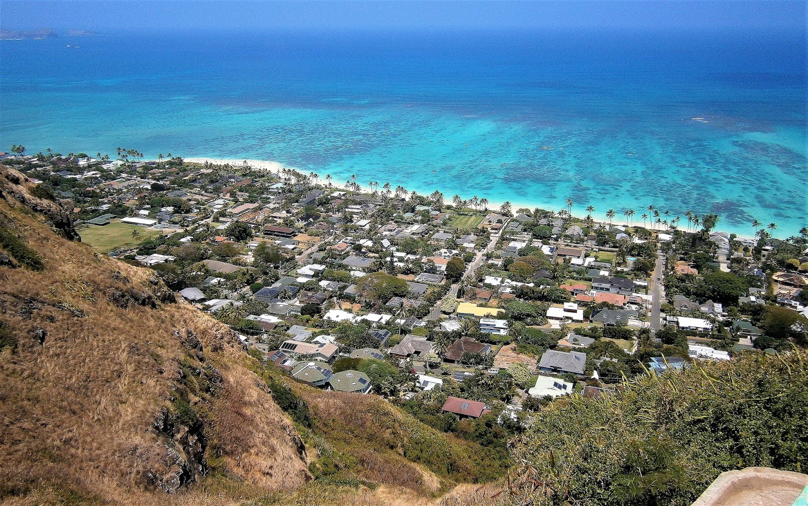
The favoured viewing spot at the pillboxes is on the roof. That is the excellent LANIKAI BEACH below, which makes my list of OUAHU'S BEST BEACHES - "Oahu's Best Daytrip Beach" abt 85% down this page.
GORGEOUS LANIKAI BEACH
LANIKAI PILLBOXES FROM THE BEACH
....to be accurate, from N, KALAHEO AVE behind the beach. CHARCOAL ARROW - 1ST PILLBOX....YELLOW - 2ND PILLBOX. Might be clearer if you can click-expand image.
FROM THE OTHER END....
The houses of the LANIKAE BEACH area of suburban KAILUA are right down there.
A bit further east - the rather excellent beach area. I spent some time there before coming up to the pillboxes. Walking time from the northern (left) exit to trailhead abt 8 mins (600yards/550m)
 Further east again - offshore island is MOKULA - it or its neighbour MOKU IKI (just visible at right) seemed a popular destination for kayakers: plenty of rental kayaks on LANIKAI beach. I've heard coral is okay off the beach some distance - was too lazy to check.
KEEP ON WALKING
Lotsa people were making the FIRST PILLBOX. But all should continue the relatively short distance (a few hundred meters/10 mins max/not too steep) to the SECOND PILLBOX.
 This is probably the best panorama in the area. Arrow shows FIRST PILLBOX. Above arrow is MOKAPU HEADLAND with the loooong KAILUA BEACH stretching towards camera - its southern end is below arrow. LANIKAI BEACH is at far right. I noticed maybe 50% of people were making the extra trek to this SECOND PILLBOX. But it is here I reckon the average visitor should tun around and retrace their steps - total time taken TRAILHEAD-RETURN abt. 1 hour.
But keen trekkers can continue on.....
....KEEP ON WALKING.The track (aka the KAIWA RIDGE TRAIL) continues in a south-west direction along the ridge top for more than 2km/1.2mi. It is not flat – in the first half it undulates between 9 knolls, all higher than the second pillbox. The 5th knoll is the highest. There are no steep uphills along this undulating section although a couple of the short downhill sections are steepish and rocky.
 Outlook from the 5th knoll - as you can tell from the horizon it is higher than those before it. The 2nd PILLBOX is just out of frame left.This WINDWARD COAST gets more rainfall than a lot of OAHU but the area looked to me to be a bit dry. Mind you it didn't rain in the 3 weeks I was on the island.
DIVERSIONS
To both sides of the 9th knoll are two side knolls worth checking out – the one to the right (north) is reached on an easy path in about 5 minutes and has good views over inland suburban KAILUA and the KAELEPULU PONDS lake area (let’s call it THE PONDS' OVERLOOK).
OUTLOOK FROM THE PONDS' OVERLOOK
SOUTH-WEST KAILUA goes inland towards the formidable KO'OLAU RANGE which separates this eastern WINDWARD COAST from the southern HONOLULU COAST.
AND THE KAELEPULU PONDS THEMSELVES
This is the view a little to the right of the previous shot. i noticed it was possible to take a trail from here down into the suburban streets - this is the trail shown on GOOGLE MAPS.
BACK AT THE 9TH KNOLL
The southern knoll is reached on a longer (10m+) side track that has some pretty steep drops and rises – it overlooks BELLOWS AIRFORCE BASE/BEACH to the south and suburban LANIKAI to the north. I’m calling this BELLOWS' OVERLOOK.
OUTLOOK SOUTH FROM THE BELLOWS' OVERLOOK
The beach is the excellent BELLOWS-WAIMANALO which is my personal best beach on OAHU - more details about 90% down this page. BELLOWS AIR BASE is behind the beach center image. The far headland is MOKAPU'U at the south-east corner of the island as featured up page. I noticed there seemed to be rudimentary trails down towards BELLOWS but they looked pretty rough and uninviting. There was a better but very steep trail on the other side of the knoll leading down into suburban LANIKAI BEACH. A local guy took it - must have been successful because he didn't reappear on my journey back to KNOLL 9, and I trek pretty slowly.
KAIWA TRAIL TO THE 9TH KNOLL and DIVERSIONS

BELLOWS AIR BASE can be partly seen lower right. The continuation of the KAIWA TRAIL is marked lower center. I forgot to add a linear scale - it is 1200m/1310yards in a direct line between the place-markers for PONDS' OVERLOOK and BELLOWS' OVERLOOK.
LOST!!
Back near KNOLL 9 I could see the main trail going mainly along the top of the ridge for another km or so, so I decided to head on to the south-west.
Now here’s the thing – after knoll 9 the rest of the ridge is considerably lower – the trail actually dives down a slope to the right. So I followed this and SOMEHOW LOST IT. I found myself bush-bashing down thru fairly thick thorny scrub on the AIRFORCE BASE side of the ridge. The track seemed to have vanished. But I figured it must be somewhere up on top of the ridge so I climbed to the right and sure enough, found a pretty clearly defined trail that headed down and then up again along the undulating lower western part of the ridge. After 10 minutes or so it took a major downhill trajectory and landed in a saddle with a choice of about 4 different paths. When in doubt, I always take the most defined which led in a north west direction and then started dropping towards the suburban streets of SOUTH WEST KAILUA. I eventually came out some distance east of the very end of the ridge top trail (see map below).
KAIWA TRAIL CONTINUED
The LOST and TEZZA EXIT routes in black don't show up very well - maybe you can click expand image. As can be seen, the ridge-top trail continues on some 900m/980yards past the start of my exit track. exiting at KUPAU ST, south-west KAILUA.
Linear scale - 12OOM/1310Y (again) between place markers for 9TH KNOLL and KAIWA CONT.
The very end of my trail was problematical. Not so much this section behind the suburban houses of APOKULA PL (not far off main drag KEOULU DRIVE) One of the residents or a keen trekker had decided to make the walk easier by putting in these steps. It was the actual access to the street which proved a bit tricky without moving thru someone’s property. But I minimised this by using a side approach to an end property and only trespassing on the driveway.
THE SHACK
From my trail's end I headed north down a few side streets and ended up on KEOLU DR which heads down towards KAILUA BEACH and runs past ENCHANTED LAKE SHOPPING CENTER. On the corner opposite the shops was a neat little neighbourhood bar called THE SHACK. It was about 5pm and they had $2 happy hour beers. I’d been trekking for 4 hours or so and a beer or 3 was just the thing I needed.
KAILUA BEACH LOOKING SOUTH
KAILUA BEACH LOOKING NORTH
I finally made it down to KAILUA BEACH but it was a bit late in the day to appreciate what a lot of people regard as the equal of my favourite BELLOWS-WAIMANALO a few km further south.
LANIKAI BEACH is just past the far end of the first image.
---------------------------------------------------------------
IF YOU SEE MISTAKES OR HAVE EXTRA INFO, PLEASE POST BELOW. BUT IF YOU HAVE A QUESTION PLEASE ASK IN THE FORUM SECTION WHICH I CHECK MOST DAYS WHEN NOT TRAVELLING WHEREAS I RARELY REVISIT DESTINATION PAGES LIKE THIS.
 GRAND TERRE relative to LIFOU and MARE (LOYALTY ISLANDS) and ISLE OF PINES.
 This page's beaches relative to CBD and CONTAINER TERMINAL (where big cruise liners dock). The CRUISE TERMINAL where small and intermediate liners tie up is just left of the CBD PLACE MARKER.