Thursday, September 24, 2015

GRAND CANYON TREKKING


THE GAME ISN'T OVER WHEN THE FAT GUY KISSES THE SCHIST


O'Neill Bluff (mid image), about 35% down the South Kaibab Trail - image should click-expand nicely.

Listen up. All those DONT'S National Parks put up about hiking the Grand Canyon are aimed at blokes like big Bob from Biloxi with his bountiful beer belly – dude might have aced a below-rim walk 10 years ago when he was a BCU linebacker, but that was then – these days he’s gonna be the first to head-butt the trail on account he aint exactly in good condition. And Canyon rangers are less than whelmed hauling 250lb dudes onto the medivac ‘copter.

Hence their warnings – DON’T go more than one hour below the rim, DON’T go below the rim at all in summer, DON'T be on the trail between 1000 and 1500 and DON’T go alone. Well at one month short of my 70th birthday I ignored all that. I was below the rim for over 9 daylight hours traveling some 14 miles (23km). So your big Grand Canyon trekking plan is not necessarily out the window - I’m sure most of you can do similar with adequate preparation.

First the negatives: it was a hot day in mid August. Like many geezers my knees are dodgy from too much jogging when young and my feet are not in particularly good shape – some arthritic bumps, and a few gnarly toe nails point in the wrong direction. I’m not a regular trekker. I live at sea level and have no idea about the impact of altitude. I’ve never trekked the desert but I’m no stranger to hot days.
The positives: I’m used to exercising in hot humid conditions which I reckon are just as trying as very hot dry ones. I’m extremely fit from daily swimming and cycling and decided to work on my trekking with some pretty hard one to four hour walks around my super hilly home town every second day loaded down with about a gallon (4 L) of water and some eats. I have to tell you, water is heavy stuff. At the end of 3 weeks of this I was so fit I had muscles on my boogers. I'm normally one of those dudes look like an overtrained, underfed greyhound but at the end of all the extra work I people were mistaking me for Iggy Pop's pop.

 Hey, maybe not his pop. I just read Iggy is almost as old as me. Kinda looks it. So picture this dude with white whiskers, a buzz cut and an even more beat up head, and you have the....um....picture. That arm bandage looks a bit dodgy (image TwentyFourBit) 

I invested in a good pair of mid-range trekking shoes and some cushioned hiking socks, trekking poles and a hydration pack. Sipping every few minutes without interrupting progress is the way to go. I also had plenty of electrolyte. Plus trail mix and a couple of commercial power bars which I munched frequently whether hungry or not. Altitude proved no problem – maybe because I had two days in nearby Flagstaff plus the previous day trekking the Canyon rim trail for nearly 7 hours to acclimatize. 
An important point - I trimmed my toe nails as short as possible. Even good-fitting shoes will see long (or even ordinary length) nails banging up against the front on sustained steep downslopes - they can get miserably sore.

THE ROUTE.
One DON'T I didn't ignore - DON'T try to hike down to the river and back in one day. 
It wasn't that I thought I couldn't do it with adequate preparation - more the fact that I didn't want to wreck myself up on account I had some big treks planned for Yosemite and Mt Whitney in the following week. Plus I read the whole thing takes 15 hours** and I wanted to be on the (return leg) upper Bright Angel Trail before dark - there are some killer views up there. 
**Having done maybe 3/4 of a river-return I reckon 11/12 hours is more like it.

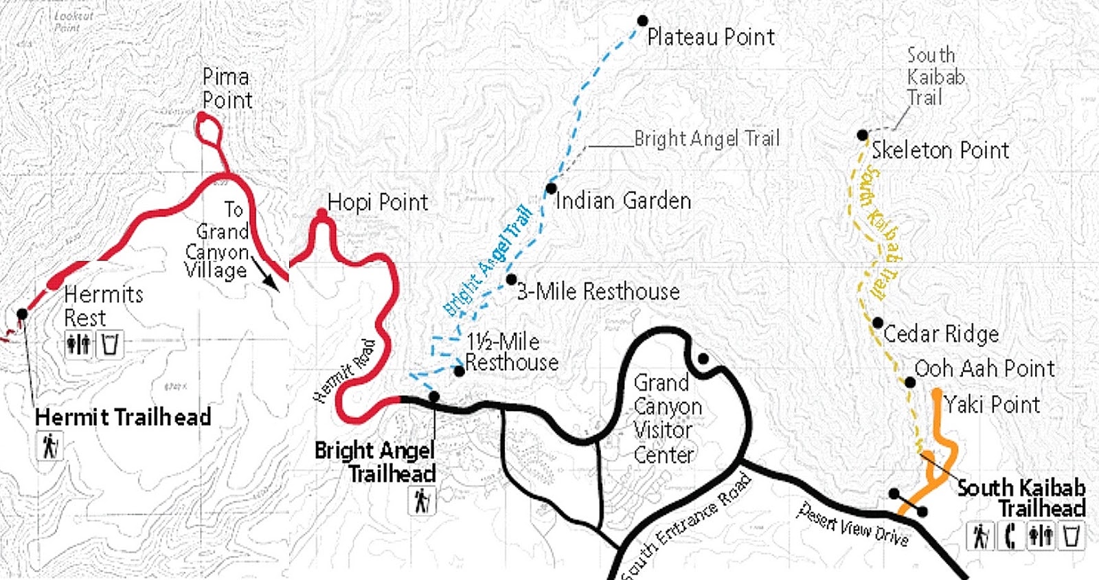
So I decided on a truncated deep canyon walk - down the South Kaibab Trail to the Tonto Platform which is about 70% down canyon, across the Tonto Trail to Indian Garden, and then back up the Bright Angel Trail to the rim.
Map's red route shows the full river-return loop but you can see the Tonto Trail meandering its way between the 2 main trails (it actually continues both sides for a good 50km+)
All the experts advise going DOWN the Sth Kaibab on account it has no water, very little shade and is steeper than the Bright Angel. The latter has water at 3 places on the ascent and far more shade from side canyons (image HikingOC)


For more detail this topographic map of the area does nicely - if you go to the original at  http://files.meetup.com/1554500/GrandCanyon_BrightAngel_Kaibab.jpg it click expands nicely once open.

THE SOUTH KAIBAB TRAIL
I deliberately ignored all the advice about a sunrise start [this gets trekkers off the trails (if they are not trying the full river loop or my truncated route) before it gets too hot]. I didn’t want to haul myself out of my sleeping bag at 4am - it can get real cold (near freezing before the sun gets a chance to warm things up) in a tent up on the high rim even in August. 
Chez Tezza, Mather campground. Bouquets: inexpensive (half the price of Big Sur NP camping), spacious sites in a nice wooded setting, quiet, on shuttle bus route, 10 minutes walk to big general store. Brickbats:  pay showers and clothes washing, no close fresh water or trash bins.

 Plus I figured a later start would ease the temptation to keep going past the Tonto junction to the river, on to Phantom Ranch and then back up the Bright Angel Trail – as said that would entail a longer hike and perhaps wreck me for several big upcoming treks. Or miss the great views on the upper Bright Angel due to darkness. 
For the same reasons I took my car to near the Kaibab trail head rather than the shuttle bus That would force me to be out of the canyon reasonably early so as not to miss the last shuttle across from the Bright Angel trailhead to retrieve the car – I didn’t fancy a 3+mi/4.8+km walk after more than 8 hours in the canyon. As it turned out, parking problems saw me dump the rental about a mile from the Kaibab trail head – what’s an extra mile at the start of a 14 mile trek? 
Once at the trailhead I topped up my water supplies and hit the track at 8.36 am. 
Kaibab trailhead is slightly higher than Bright Angel’s at 7200ft/2195m and the walk to the Tonto Trail junction at 4000ft/1220m is a bit shorter at 4.4m/7.1km, making the Kaibab steeper on average than the Bright Angle - considerably so in parts. It is also rougher, particularly around O’Neill Butte and below Skeleton Point, but I wouldn’t call any section unpleasant underfoot and I have dodgy knees/feet. Because the trail mainly sticks to a ridge the views are arguably better than Bright Angel’s side canyon route, but I found the latter hardly shabby. There is way less shade and no water the whole way to Indian Garden 8.8mi/14.3km from the start. So bring a fair bit. I had just under a US gallon/4L. I was surprised there was still nearly 2L left at Indian Garden.


Despite the fact I’m no Speedy Gonzales I reached Ooh-Aah Point pretty quickly – it’s only  0.9m/1.5km and a drop of 600ft/190m – there is no sign but you know you are there because the view widens into ooh-aah status.  There are great views nearly all the rest of the way but Cedar Ridge (1.5mi/2.5km from the top – 1140ft/350M below the rim – reached in 55m and Skeleton Point (3mi/4.9km – 2060ft/630m – 1hr50m) are standouts – Skeleton Point gives first view of the river. There is a restroom at the former.
Fellow trekkers take a rest at Cedar Ridge. Opening shot up page was also taken from this area.

Shortly after Skeleton Point I hit these numerous and rather steep switchbacks. This section has probably the roughest track conditions underfoot but not what I would class a hassle. Lots of rock and timber step-downs, mainly single although often close but I can’t remember any steep stairways. And very few of the step-downs had big knee-wrecking vertical drops. I think you can begin to see why the experts recommend going DOWN the South Kalib. The Bright Angel has some great switchbacks, but the gradient is less than the above.

The second of two mule trains I met during my nearly 3 hours on the South Kaibab. The first was carrying baggage - above we have a bunch of people returning from overnighting at Phantom Ranch.


Dude in charge was stopping frequently to give detailed info to group - they must have left the ranch real early because they were not making fast progress - although faster than I could walk out. Hey, Biloxi Bob can make it down and back this way (at a price).

There was only a moderate number of people heading down the track (probably more with a sunrise start) - I winced at the 4 joggers who overtook me: hope they don’t end up with knees like mine (you know that old dude you see fanging around your shopping center on a sit-down skateboard using hands for propulsion – the one who is always getting busted by the cops for biting pretty girls and security goons on the knees? He was a canyon jogger).

Whoa! These maniacs run back up too - not as hard on the knees but pretty taxing on the fitness. I remember I use to run hills on my treks back in the day - none with the length of these though. I was a bit slow with my camera on the joggers - had to borrow this from 123RF.


Canyon running can have all sorts of physical consequences. Little dude looks like he packs a good knee-bite (image bailey unleashed.com)

About 10 minutes before reaching the Tonto Trail junction (4.2m/6.8km – 3100ft/950m below the rim) the trail flattens onto the gently sloping Tonto Platform. The trail junction is just short of the toilet block (center of image) near the Drop Off - the very steep drop to the river. I reached the junction at 11.26am, 2h50m from the start – with about 10 minutes out for pix and refreshment stops this meant an average of 1.6mph/2.6kph. Did I mention Speedy Gonzales?

I blocked the urge to go the short distance to the Droppoff with its views of the river because I knew with only a further hour and 1.8m/2.9km walk – 1600ft/490m drop to the Colorado I wouldn’t be able to resist going on down. So I wandered around the rest area, rehydrated and refuelled on trail mix/power bars and then set off across the Tonto Trail at 11.43am.


THE TONTO TRAIL
The Tonto Platform is a band of erosion-resistant sandstone about 3/4 the way down the canyon. The Tonto Trail winds its way along 70miles/113km of this – the section between my down and up tracks is the most used and as such is in pretty good condition underfoot although a step down from the other two trails. The roughest section was just out of Indian Garden but this was reasonably okay. 

Straight line distance between the two trails is only 2.2 miles/3.5km  but because the Tonto winds back towards the rim cliffs to clear 3 side canyons, total walking length is 4.2m/6.8km.

This view from the south rim gives some idea of the Tonto - trail junction with the Sth Kaibab is around the thin hexagonal top right (under"6.8" - might be clearer if you click-expand). It then comes around Skeleton Point bluff towards camera to reach the twin Pipe Creek side canyon heads where the bigger stars are located. Eventual destination is Indian Garden in Bright Angel Creek side canyon where the downwards arrow is (Indian Garden is hidden behind the bluff to the left). The small rectangle shows Plateau Point where you can look down to the river - the small diamond is over the fairly flat 2km side track from Indian Garden to Plateau Point.
Please excuse amateurish graphics - I'm still trying to teach myself how to use the PAINT thingy on my basic Windows photo editor.


This may make it a bit clearer

I modified this Google Earth image to show much the same thing, The yellow track is of course the Tonto, white the Sth Kaibab and blue the Bright Angel. The river can be seen top left. The (fainltly visible) flat trail out to Plateau Point leaves the western extension of the Tonto at left.
It's hard to put a linear scale on these images with lots of vertical relief - the straight line distance from the Indian Garden place-marker at left to the Trail junction marker at right is 2.2miles/3.5km 

In the above shot the trail is skirting around the eastern arm of Pipe Creek side canyon. In parts it gets quite close to the steep drop-off from the rim.
The trail is pretty flat – the only sustained uphill section was out of the biggest side-canyon but this will only have Biloxi Bill moaning - and wiiide William moans when he turns over in bed. In the opposite direction the climb out of Indian Garden is similar – btw the Tonto hits the Bright Angel trail at Indian Garden about 10 minutes south of the water supply/camping/ranger areas. 


I found the Tonto a nice contrast after overdosing on down-canyon views from the previous day's rim trail and when coming down the Sth Kaibab – the outlook  is more across and upwards to each rim (only at one side-canyon head did I get a glimpse of the river). At a few places I was virtually directly under the south rim. In the shot above we are looking across at the north rim - it's closer in real life: when I forget to crank a bit of zoom into my elcheapo Olympus', its natural wide-angle tends to lengthen distances.


There is virtually no shade along the Tonto and apparently it is often above 100F/38c in summer  (felt mid 90s when I crossed) – however the best place to stop for a refresh is at the halfway point - the western Pipe Ck canyon head where there are a few trees for shade. Water was running here so if you bring some purifying tablets you don’t have to carry quite as much from the top to make Indian Garden. All creek crossings were easy although snow melt  time may be different. There were no problems with thorns etc which can cause hassles on less-traveled sections of the Tonto.


After the climb out of the second Pipe Creek canyon head the trail heads across the platform towards Bright Angel Canyon. This is the most exposed section but seemed to pass fairly quickly for me.


First sight of Indian Garden as the Tonto drops towards the junction with the Bright Angel Trail. This is some 10 minutes down the side canyon from the camping/park ranger section.
I arrived at the junction at 2pm - taking out maybe 10 minutes for photographic and refreshment stops the 4.2m/6.8km. had taken me a bit over 2 hours. 
I saw no other person on the Tonto.


Indian Garden is a neat little oasis which lines the gushing Bright Angel Creek for over a km. The camping and ranger area takes a small proportion of this. 
It is easy to see why the Hopi indians used to farm this area.
The lower shot also shows the track out to Plateau Point (top right) and the relatively gentle Bright Angel trail the first few km towards the rim at bottom (looks like 2 tracks but one is the creek)


There is safe drinking water and because there are two other refill areas further up  the trail at about 1.5m/2.4km intervals I felt no need to carry more than 2 quarts/liters** to cut weight. I spent 40 minutes at the Garden - water out of the pipe was icy cold and I treated myself and clothes to a cooling shower. And it was a great spot to load up on the trail mix and power bars.
** 1 liter would have done it but I carried a reserve in case one of the water heads was out of action
I was still feeling pretty good but resisted the 3m/4.8km return trip out to Plateau Point’s views of the river as I wanted to make the rim before sunset.

There were few people at Indian Garden. Hikers who leave the canyon bottom and Indian Garden camping area at first light would have been long gone - those waiting for the cool of late afternoon to hike up from the Colorado would not arrive until near sunset. And it is too far down from the rim for most day hikers.


THE BRIGHT ANGEL TRAIL
I started my ascent from Indian Garden (which is 4.6 miles/7.5km below the rim and 1.5m/2.4km above the Colorado River) at 2.40 pm.
The first quarter of the hike out from the Gardens is pretty easy – up moderate slopes beside the creek – even my svelte-challenged mate Kananga (who has never failed to completely surround a 12inch/30cm coconut-cream pie in one sitting) would do this with only one or two pit stops. 


However a National Parks medivac helicopter landed and shortly afterwards took off a short distance up the track. I can't believe Biloxi Bob got this far down. Maybe Kananga had ignored a pit stop. Kananga's sensational squeeze, the scintillatingly sensual Siam Soonay, administers the CPR kiss of life almost as often as a pash of passion. 


els
images Bob's Pixels

About Ikm short of the first Three Mile (from the top) water/rest stop I left the moderately sloping Tonto Platform and started the slog up steeper stuff. I gotta say when I looked up I thought: “how the hell am I going to get up there in only 3 miles?” But the fact is the series of switchbacks do it in style – at no time did I think the slopes went beyond "steep" into "heartbreak" category and reasonably fit people will do it in easily. Kananga and Bob would be calling for that ‘copter. 
The trail itself is in pretty good condition with few rough sections although there is no shortage of those step-ups (fortunately mainly singles – I can’t remember any steep staircases). And the good news is that this late in the August afternoon the I soon enter the shadow of the rim (earlier in the day, side-canyon walls give a fair bit of shade).


View from the rim shows last of relatively flat Tonto platform far left, series of awesome switchbacks up the steeper stuff and the Bright Angel trailhead at the top (uper right).
I had to tilt the camera to get it all in - should be a good pic to click-expand.
Lower switchbacks


A shot from about 3/4 up the swichback shows Indian Garden in background, the relatively mild slope of the trail to the beginning of the switchbacks and those lovely canyon shadows.

From around the One and a Half Mile rest stop the trail got busier – it was clear that a fair few people were doing an afternoon hike down from the rim. Many were in not particularly good shape and a lot had inadequate water and unsuitable footwear. Unfit most were but they seemed to walk faster than my shuffle - however I soon passed them because of their frequent stops. 
Trekkers co-opted to snap pix seemed prepared - not so the subjects. No worries, this arch is close to the rim.

I finally topped out at 5.50 pm nearly 9.5 hours after I started at South Kaibab trail head. I was probably walking for 8 3/4 of those.It took me 3 hours (after taking out 5 minutes at each rest stop) to walk up from Indian Garden  – that’s just over 1.5mph/2.4kph which is close to my average down the South Kaibab and across the Tonto.
I was in such a hurry to jump on a free shuttle bus to go fetch my car 3m/5km away (in the forlorn hope I would get back to my tent before dark - mucking about with tents under torchlight is almost as bad as making up a bed in a hostel dorm with the lights out) that I forgot to take a shot of the trailhead, so I had to pinch this one from National Park Service.


By the time I got back to the campground, showered and changed it was well after dark. I was busting for a feed and a cold beer. The only close by was at Yavapi Lodge’s cafeteria – I found it overcrowded, the food ordinary and overpriced, and to add insult to injury they served me a warm beer. Hell, if I want warm beer I’ll go to England.

REFLECTIONS
Next day I expected to be aching all over (an old guy on the rim trail the day before told me I'd be doing the 'Kaibab shuffle' for weeks) but apart from sore feet I felt surprisingly good. All that training pays dividends.

Could I have done it without extra training? I think yes, but I reckon I would have suffered later. 
Could a person of normal fitness do it? Um, probably, but they would have to make lots of rest stops and would wreck themselves up for a long time. 
Would under-fit (which for many is normal-fitness) people do it? No way. 
In all cases I’m assuming similar hydration and tucker choices to me.
Given my extra training, could I have done the full loop to the river and back in a day? I think so, but I reckon I could have ended up with a prolonged case of Kaibab shuffle. Thing is, when I topped out at the Bright Angel rim I was beginning to think I'd had enough of hauling myself uphill - an enjoyable physical challenge was close to turning into a hard slog. To the river and back may have been a few (thousand) steps too far.

Are walking poles necessary? They were a help on slopes, and later, on a slippery treacherous downslope in Yosemite they definitely saved me from a fall, but I reckon I could have done the Canyon without them. However they might make the difference for marginal trekkers and may be one reason why my knees didn't suffer.
Hydration pack? More a convenience to save time on the frequent rehydration the experts urge. 
Good shoes? I’m amazed how well mine grip a slippery track compared to normal joggers. And combined with the cushioned socks and maybe the poles I reckon they helped save my knees.

Hell to come out of that walk without sore knees gave me such a high I needed a step ladder to scratch my arse.


THE RIM TRAIL


Biloxi Bill and friends should not be disheartened - the very best views of the canyon are from the Rim Trail which winds some 11miles/18km along the south rim. There are about 15 viewpoints along here (plus a heap more unofficial outlooks into the canyon) and for a good deal of the journey the trail is similar to the above - sealed and relatively flat. 
Frequent free shuttle buses run along roads in back stopping at all viewpoints - some stops are only in one direction so check the super-useful info sheet you get when entering the park). 
Bicycling the rim is popular (hire bikes available in the village) but seldom on the rim trail itself. Shuttle buses have bike racks for Biloxi types who suffer pedal fatigue.
A few of the western viewpoints are joined by an unsealed rim trail. People with very young kids should maybe avoid. And this is no place for Kananga to have a fainting fit.
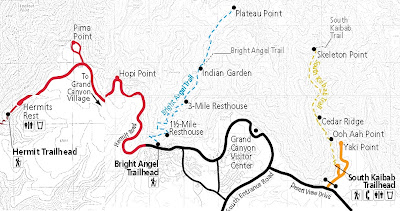
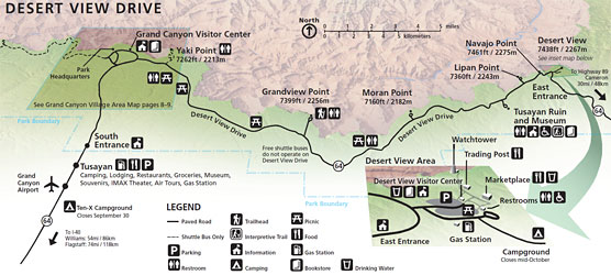
The Rim Trail runs from Hermits Rest in the west toYaki Point in the east. Grand Canyon village is roughly central (image University of Arizona)
There is a bigger, more detailed version of the above with all viewpoints, shuttle bus and other extra info on the National Park website (and you can click it to expand).


There are so many great outlooks along here it's easy to o/d on them - I liked this westward looking view from Mohave Point on account the Colorado was easily visible mid-distance (click-expand).
But arguably, the very first view most visitors see, Mather Point - a 5 minute well sign-posted walk from the first big parking area after the south gate (main) entrance - is just as spectacular.


Another nice one - this one is from the one of those many unofficial lookouts on the edge of the rim trail just north of the Abyss viewpoint. I'm thinking the late afternoon time of shot is contributing to the pic.

Late afternoon on the Rim Trail: my dance card that day was pretty full. I left Flagstaff before 0800 in order to arrive at the south entrance to the Canyon early - I'd heard there tends to be big delays later in the day. Around 0900 - no problems. 
Drove to the first parking lot, only 5mins walk to the Rim Trail at Mather Point, headed west. Over the next 7+ hours I checked the more than a dozen viewpoints and the way more unofficial lookouts to the west (I managed to cover the ones to the east next day on the way to the Sth Kaibab trailhead for the big down-canyon trek). 
I mainly walked the Rim Trail, but used the frequent shuttles to backtrack/sometimes jump ahead. Logistics mean that occasionally I had to double walk a section between viewpoints, and maybe missed walking 2 short sections.
All of this was very time-consuming - by the time I caught the shuttle to the car park and drove to Mather camp ground it was dark. Have I mentioned how I hate setting up tents in the dark?
Once I set up, I invited neighbouring campers around for a beer. 
(image The Mad Men Review)


DESERT VIEW DRIVE
Some further rim-top views can be seen along this road which leads from Grand Canyon Village to the lesser used eastern park entrance. I used this to exit the park on account I wanted to cruise Wapaki Monument/Sunset Canyon Drive which loops off highway 89 on the way south to Flagstaff. You can see the loop under UNEXPECTED GEMS 20% from the top of my THE GOOD, THE BAD AND THE UGLY page 

There are 6 viewpoints along this 25mile/40km road - most are pretty good but not a step up from the Rim Trail average. An exception is the last one, nearest the eastern entrance - called simply DESERT VIEW, it singles itself out by being the highest point on the southern rim (7438ft/2267m) with fabulous views to the north and east and having the DESERT VIEW WATCH TOWER (image - National Park Service)


The tower was built by Mary Colter in the early '30s in the style of Pueblo watchtowers both internally and externally. It is situated near the edge of the rim - the rooftop has really great....


....views to the north east. Note river in mid-distance.


One of several internal levels.


IF YOU SEE MISTAKES OR HAVE ADDITIONAL INFO PLEASE MENTION THEM BELOW - BUT PLEASE DIRECT ANY QUESTIONS TO THE FORUM SECTION - I DON'T LOOK AT THESE INDIVIDUAL PAGES VERY OFTEN BUT I CHECK THE FORUM MOST DAYS.

Tuesday, September 15, 2015

THE GOOD, THE BAD AND THE UGLY


Okay, so the spaghetti westerns were shot in Spain. But of course, there's no shortage of this type of country in the USA south-west (image The Man Zone)

TEZZA RATES THE SOUTH WEST

Following is a lot of judgemental stuff on the best, worst, yawn-inducing, praise-worthy and annoying aspects of the south west. You may ask what qualifications I have. Well none, apart from excellent taste and the fact that I have always been very opinionated.

An outline of my 31 day visit: I did a loop of most of the popular locations in the south-west. After spending 4 nights in Santa Monica, 2 in North Hollywood and 2 in Long Beach I grabbed a rental car and headed for Flagstaff and the Grand Canyon, Las Vegas, Death Valley, Yosemite, San Francisco, Big Sur and San Diego where I returned the car. After 4  nights I Amtracked back to LA for the flight home. I'd liked to have had the time to fit in Lake Tahoe and there were many more I did check out where I would have liked to stay longer - a half dozen spots along/just off the really nice US395 which runs up the eastern side of the Sierra Nevadas I could have spent a fortnight exploring. I gave Disneyland the big miss - when I was a surfer-grom I had a crush on Annette Funicello (yeah, I'm a seriously old dude) but in my adult life I've grown to abhor overpriced,/over-hyped attractions, long queues and crowds.


Main destinations - overnights or more at all those places apart from Death Valley and Yosemite Valley. Plus nights at Flagstaff south of the Canyon, Lone Pine - L P on image - (past the heat of Death Valley), Midpines (for Yosemite) and San Luis Obispo - S L O -  plus Ventura (both between Big Sur and San Diego). My ticket from Alamo tells me I traveled 2761 miles which is 4473km. I did many more kilometers in city buses and trains plus intercity Amtrak. 
The distance line between the aircraft and San Diego bottom left is 400km long.
I travel budget and stayed at 2 camp-grounds, 8 backpacker hostels, 2 budget motels and one Las Vegas casino (which because of the gamblers' subsidy was no dearer than the budget motels. But way sweeter. Not that the budget motels were bad).
HEY - THOSE COLOURS (get used to Brit spelling you Yanks) I USED ON THE MAP DO NOT STAND OUT REAL WELL - THING IS, I'M NOT PREPARED TO RE-DO THE MAP ON ACCOUNT IT IS SO TIME CONSUMING - SO MY ADVICE IS CLICK-EXPAND TO MAKE IT CLEARER. FAILING THAT, TAKE A HINT FROM LINDY LOVELACE - "SUCK IT UP BABY"


MOST SPECTACULAR
The Grand Canyon has to win here....
....as did my 8+hour hike into the canyon in the BEST TREK stakes. tripadvisor report "HOW TO SING CONTRALTO WITH THE VIENNA BOYS' CHOIR" gives details. 
I also have put up a page with lots of info and pix which you can access by clicking back to the index top right of page. SHORT CUT - I'm hoping SHORTCUT works fer yu - the previous link didn't fer me.


.....Yosemite wasn't far behind (smoke from big forest fires in the south-east Sierras makes for inferior pix).
One of my Yosemite treks was of similar duration to the Grand Canyon stroll, but way harder despite the kinder temperatures - wins title of MOST STRENUOUS TREK. This is due to knee breaking, treacherously slippery multi-stairs on the MIST TRAIL section of my walk - people above are just about to start the descent. A lot of them fell over - I would have except for my trusty hiking poles. 
I have also done a separate page on Yosemite.

As far as man-made structures are concerned....
....the Golden Gate does the job.


OVER THE TOP
Vegas gets the gong here of course. Over the top is no criticism - I enjoy such places


OVERBLOWN/UNDERWHELMING
I was disappointed in Monterey. Cannery Row was hard to follow and seems to have been gentrified to the point where Steinbeck must be rolling in his grave - upmarket shops, accommodation and restaurants lend a slightly pretentious air. The Fisherman's Wharf area (the commercial one - at least there is still an adjacent working wharf) can't hold a candle to Pier 39 in 'Frisco or Santa Monica's beach pier. The coastal scenery is okay but no better than a dozen other places along Highway 1.


SLIGHTLY UNDERWHELMING - BIG SUR
Blasphemy I know, but I found Big Sur less mind-blowing than I'd expected. Trouble is I'm spoiled: I live right on the coast and have seen hundreds of whales, dolphins and the rest. And being a beaches/islands guy I tend to seek out scenic sections of coastline - I can think of another half dozen seaside roads which can equal Big Sur's landscape and which have far better beaches. And none of them have the restrictions on parking, the high cost of same and of accommodation; or the hoard of "DO NOT... restrictions found at Big Sur.
However I can well understand the raves the place gets - if I lived inland and rarely saw the sea I reckon I too could be blown away. 
In summing up, I don't think Big Sur was a waste of time for me. I reckon it was well worth the visit - just not as exceptional as I thought it might be.


PRETENTIOUS
I've already mentioned Monterey. I also thought all those gated estates in California were bunging it on a bit with residents turning up their noses at outsiders and thinking they were living in some special place. Stand by for an incoming boast: Chez Tezza perched on a low seaside cliff on the NSW coast would blow them all away location wise.

Anyway, pretentious in a good, entertaining way was.......
....Rodeo Drive with its flash shopping, ritzy restaurants.....
....outrageously expensive and ostentatious cars, plus big homes (no gated estates I could see).


Spot the Celebrities tour spot a real celebrity - click expand baby.


UNEXPECTED GEM
There was a bunch of these. 2 standouts:
1 - Wapaki Monument/Sunset Crater Scenic Drive which loops off Arizona's route 89 (this is used to get from the eastern entry to Grand Canyon's south rim to Flagstaff). Above are some housing ruins of the Pueblo native Americans who lived in the area from around 500 ad to 1225. I'm not into archaeology but I found the ruins and the information in the museum fascinating - so much so that I stayed way longer than anticipated, meaning I made Hoover Dam near 'Vegas much later than planned....
....on a moonless night. 
Oops! There's a killer dam wall, lotsa water and a deep gorge down there somewhere.
Sunset Crater back on route 89 aint exactly Mount Rinjani but was interesting and also cost more time than I'd budgeted.


2 - Sedona
Sedona Az is 50km south of Flagstaff on 89A. This town has it all - drop dead surrounding scenery, new-age stuff like vortices, lotsa trendy shops/bars/restaurants, heaps of accommodation plus the wonderful Oak Creek Canyon which runs several km along 89A just north of town. I only visited Sedona for an afternoon but if I return to the area I'll make sure I spend a couple of nights.
Area scenery attracted early movie-makers. The list of westerns made here is long and contains many classics. Hollywood owes a debt - the story is one of Hollywood's pioneers  earlier called in here and found it snow bound. So he jumped back on the train and continued thru to the sun of the Californian coast (image psychicnirup.com on account my camera's battery went flat and my backup Olympus got drowned when I fell out of a speedboat at the Thai islands).


BETTER THAN EXPECTED GEM
I expected the Midway Museum at San Diego to be pretty good but it proved even better.
Midway has an example of every aircraft that has flown from her - plus ones involved in the Battle of Midway for which she was named (she was completed just before the end of WW2 - built for the invasion of Japan which fortunately did not occur - can you imagine the loss of civilian and armed forces life in a country which would never surrender to conventional force?)
She still looks impressive. Midway is parked less than 400m from the nearest downtown office building.
A Midway vet (Vietnam era Crusader pilot) gives an entertaining talk about the catapult launching procedure including humorous anecdotes re SNAFUs. Equally good was the guy doing the landing area talk.
You can also check out crew quarters, sick bay, the mess, engine room, do a guided tour of command-central in the island (superstructure) and much more.
I expected to spend 2 hours here - I stayed over 6. Which is why I never got to San Diego's famous Balboa Park


MOST CROWDED
Um - crowds in California's/Arizona's/Nevada's tourist season. Not exactly lacking in choice but I'd be giving to......
San Francisco's iconic cable cars....
...queues at Union Square's cable-car turn-around spot.


BEST PEOPLE WATCHING
Another one not  lacking in choice. Was it at Santa Monica pier? Or just inland at the great 3rd Street Promenade? Drinking craft beer at a street-side Main Beach San Diego beer counter saw no shortage of colourful passing characters. Neither did a similar foot-path facing bar on The Strip at Vegas. Speaking of which - just sitting in the foyer of one of the Casinos was good value. I could go on, but I'm going to give it to the Grand Canyon's RIM TRAIL, where you can see all sorts of people from all over the United States plus a huge array of foreign visitors - all in full on holiday mode.
Cute sight - kids being awarded their honorary ranger status after reciting an oath of allegiance to the environment. A whole bunch of appreciative adults just out of frame to the left.


HOTTEST
Badwater Basin, Death Valley California. The temp gauge on the dash of my rental read 127F which is 52.8C baby. Good grief! Although I have never experienced temps above the mid 40Cs, I reckon the temp gauge was pretty accurate - when it was showing 95F/35C at Flagstaff it certainly felt around that level.
Note it was still 120F at Death Valley's Furnace Creek tourist "oasis" at 6pm - I'm glad I'd booked accommodation at Lone Pine on the lower slopes of the Sierras rather than pitch my tent at the Furnace Creek campground.


COLDEST
Mather campground, Grand Canyon Village south rim. You are at 6860ft/2092m here in a desert environment with no insulating cloud at night, so even though it was mid August, night time temperatures were often close to freezing. Tents can get real cold at night so I made sure I rugged up well - was snug as a bug.
Note my Nissan Versa rental at back - horrible car! The understeer king of the highway screaming its lungs out near 5000rpm trying to keep up with traffic on interstate upgrades. I thought Alamo was giving me an upgrade from the promised (smaller) Chevy Spark until I read the Versa was the cheapest new car on sale in the USA. At least I squeezed 43.7 US mpg (5.4L per 100km) out of it (I'm a fuel nazi/mileage maniac) - but my own bigger, faster, more comfy Elantra has averaged 49 imperial MPG (5.8l/100km) everywhere since new whereas the Versa did mainly highway miles. The Elantra is often around the 4.9L mark on the highway.


MOST UNEXPECTED WEATHER
I'm fanging across the Mojave Desert above but a bit later in the day from his pic - only a few hours out of L A - scattered cloud, 120F outside according to the dash temp gauge - and it starts to rain! Short and sharp, which is text book desert rain - but we are talking about the middle of summer which is normally southern California's driest time, in a drought which has lasted 3 years.


HIGHEST
Lone Pine Lake, about 6km  up the Mount Whitney hiking track is the highest I got at 10050ft/3064m. Hell, that's the highest I've ever been apart from in aircraft - all that trekking around Grand Canyon a few days before paid off because I had no hint of altitude distress.
Mt Whitney is the contiguous 48 states' highest peak (14405ft/4421m) but I couldn't get a permit to climb the full route. Just as well - to make it up and back in one day needs a 4am start and I wasn't in the mood for that plus I had lots of other things to do that day.
The 6km climb from the Whitney Portal parking area (no permit needed) is a real nice trek thru a lightly forested area on a good surfaced track with no killer slopes - took me 4 hours return.
Note the smoke in the pic - big forest fires in the south-east Sierra made visibility quite poor. That's Mt Whitney at left - will be clearer if you click-expand.


LOWEST
Badwater, Death Valley is the lowest point in the USA at 282ft/86m below sea level. As I said up page, outside temp here was 127F, but I could't resist a stoll 300m out to the lowest point just out of frame top left. You can tell it is the lowest point - water leaks out of an aquifer near the platform, flows down to the lowest point where it evaporates, leaving a mini salt lake.
A neat touch - National Parks has put a  SEA LEVEL sign on the escarpment behind the parking area - check just below the black arrow (sorry about the positioning and colour of the arrow but that is my first try at Paint Box)


HAZIEST
I've already mentioned the big forest fires in the SE Sierras - these burned over several weeks and made visibility very poor over a big section of my trip. Above is Zabriski Point which is one of the highest places at the top of the escarpment in the previous shot at about 800ft/244m above sea level. Pity about the smoke haze because on a clear day you can apparently see both the lowest point (Badwater - 12mi/20km south as the crow flies) and the highest point (Mt Whitney - 81m/132km almost due west - would be somewhere towards the top-right of image). 


CLEAREST
Californian urban areas are not known for clean air, but perhaps the anti-pollution measures with which that state leads the world are having some impact. Above is San Francisco's notorious Alcatraz, only a few days after the previous pic - S F is too far west to cop the prevailing winds/smoke from the SE Sierra region.
Note too the absence of 'Friscos very common fog and rain - I was real lucky both days of my stay.


BEST BIG CITY
San Diego, California's second city by population after L A. 
'Frisco in 3rd place (there are probably more people in the greater San Fransisco conurbation) is a pretty nice place but San Diego edges it on account of better weather, beaches and  myriad attractions.
Above is the entrance to San Diego harbour from Point Loma . The very first landing place of Europeans in California is said to be just out of frame to the left of that warship.


BEST MEDIUM TOWN
I thought San Luis Obispo between Big Sur and Santa Barbara was a terrific town but once again I judge another as superior - Flagstaff Az south of the Grand Canyon. Flagstaff is a nice place in itself with a very relaxed feel, lotsa good value accommodation and plenty of eats and drinks joints in keeping with its functions as a college town and a base for the Canyon + winter sports at the nearby Arizona Snowbowl. It has a host of other interesting attractions nearby like the Wapaki Monument/Sunset Crater Scenic Drive shown up page, other native American archaeological sites, the fabulous Sedona/Oak Creek Canyon and more. And for nostalgia freaks, old Route 66 runs thru town.


Walnut Canyon is 12mi/20km by road from Flagstaff (you can cruise Route 66 for half the trip) and is the site for the abandoned cliff dwellings of the Sinagua people who lived here from abt 1100 to 1250.
If you click expand the first shot, you can see at center a dwelling on the adjacent canyon side.


BEST SMALL TOWN
 Lone Pine runs north-south for just over a kilometer along California's 395 on the eastern side of the Sierras. It has a fabulous small town atmosphere (friendly and unhurried) and a surprising number of good places to eat. As the first cooler spot to stay out of Death Valley (it's 3727ft/1136m above sea level) and a base for Mt Whitney climbers) there is a good selection of accommodation. Death Valley begins 80km by road to the south-east (take 136/190 just south of town), Whitney Portal - the car park/camping area for Mt Whitney is 20km west along the climbing (goes from 1136m to 2550m) and scenic Whitney Portal Rd from town center (for a very scenic detour take the Movie Flat Rd/Hogback Rd loop which takes off o the right thru the Alabama Hills [site of many old movie productions] less than 5km out of town - note the road turns to dirt after a short distance).
There are so many attractions on and just off the next 150km north along 395 I could have spent a week exploring them. I particularly liked the Mammoth Mt/Lakes area abt 170km north, and Mono Lake 200km north - but my research showed another half dozen could well have been as good/better. 
My final destination that day was Midpines (for Yosemite) on the other (western) side of the Sierras (and 370km from Lone Pine) but I'd spent so much time on the eastern side I didn't arrive until after 11pm. Jeez it's great fun trying to make up a bed in a dark backpacker hostel dorm.


BEST MAIN STREET/DOWNTOWN
This is a hard one to pick - smaller places like San Luis Obispo, Ocean Beach San Diego, Ventura, Flagstaff and others had pretty good main street/downtown areas, but I'm giving it to......
Santa Barbara - this larger place has the customer base to offer most things along the main drag. I particularly liked all the wine-tasting joints in the section nearest the beach although I had to resist on account I was a sole driver. Architecture buffs will enjoy the Spanish-style buildings.

In other respects I was a bit perplexed by Santa Barbara - travel guide raves are supported by sky high accommodation costs eg - a dorm bed at the HI hostel costs as much as my perfectly comfortable Pacific Inn budget motel at Ventura only 30 minutes further down the coast towards LA. But the market won't support excessively expensive accommodation over the long term - I'm a great believer that public demand determines high average accommodation prices - prices won't be high if the public isn't accepting them. 
A further observation:,Santa Barbara's beaches, harbour etc were okay, but no nicer than half a dozen other places north and south along the coast.


MOST UNDERWHELMING MAIN STREET/DOWNTOWN
No surprise here, many have mentioned the same - Los Angeles. The downtown shopping area looks like Sydney circa 1962. Shows the impact of the car/big regional shopping malls on LA's CBD shopping.


BEST VALUE ACCOMMODATION
The Luxor at 'Vegas wins easily. This huge room cost no more than Pacific Inn Motel - Ventura (itself good value as Pacific Coast holiday town motels go) and the latter didn't have the huge pool, gym, eats options and shopping available at the casino. 
Low room prices at casino properties of course are subsidized by the gamblers, but I'm no gambler - thanks Maverick and friends (am I showing my agea? If the reference to Maverick passed yu by, too right).
Actually I felt morally obliged to put a few dollars thru the slots, but these days they don't take coins which made the process more complicated for the passing person. Their loss - but I suppose they know their business. And when I recall famous economist Adam Smith's "Gambling is a tax on stupidity...." I don't feel too bad.
Sweet pool at the Luxor.

POOREST VALUE
My campsite at Pfeiffer Big Sur National Park campground cost more than some of the hostels on my trip (and didn't have free hot showers and the often free breakfasts that the hostels include) - and twice the price of Mather Campground at Grand Canyon Village. In its defence, Pfeiffer had water and trash bins close to each campsite unlike Mather and a nice flowing river running thru the site. 
A thing I liked about both campgrounds - spacing between sites is quite big which gives the impression of camping in the bush. Well maybe not if you have a bunch of college kids adjacent. I had nice, quiet, friendly folk from Phoenix. In Australian campgrounds your neighbouring tent may be less than 5m away.


BEST BACKPACKER/HOSTEL
I stayed at 8 different backpacker hostels - HI Santa Monica , Orange Drive Hostel at Nth Hollywood, Grand Canyon International in Flagstaff, Lone Pine's Whitney Portal Hostel and Store, Yosemite Bug Rustic Resort near Midpines, San Francisco's HI Fisherman's Wharf, Hostel Obispo at San Luis Obispo and San Diego's Ocean Beach International.I chose all on the basis of good location, facilities and good reviews and was not disappointed by any apart from Bug near Midpines. I chose Bug for its proximity to Yosemite Valley (all the tent sites in the valley were booked out way ahead of my visit and I couldn't afford any of the resorts in or closer to the valley) its resort type facilities and good reviews. But proximity is a loose term - it is about 55km from Yosemite Village and the scenic but very twisty drive took me just over an hour (the YARTS bus does the trip - I intended to use it until I learned it takes nearly 2 hours). So I was leaving so early in the morning to fit in my Yosemite treks and getting back so late that I didn't get a chance to use any of the facilities lauded by reviewers. In retrospect, I should have lurked on the camp booking site until a cancellation came up - after all, I had nearly 6 months.


Orange Drive Hostel at Nth Hollywood looked more like a neighbourhood house than a hostel - has limited parking out back. Like all my other hostel choices bar Yosemite Bug it was well located - in this case 2 blocks from the Walk of Fame and Chinese Theater, 5 minutes walk to the Hollywood Bowl and close to rail and bus links to quickly get you to nearby locations like Sunset Strip, Rodeo Drive and downtown or with more time anywhere else in greater LA. The famous Mullholland Drive with its good views of the LA basin , Hollywood Sign and The Valley is a 10-15 minute walk.  

Some overall judgments on my hostels:
-US hostels tend to be more expensive that ones I'm used to in Australia and Europe. For cheapskates like me:  Grand Canyon International in Flagstaff was by far least expensive at $US25 pn - and quite a good place overall: so represented  best value.
 The HI (Hosteling Internatioal) places were most expensive, but had the best dorms, kitchens, breakfasts* and overall facilities. Great locations too.
* breakfasts at San Diego's Ocean Beach International were as good. And cooking waffles at Flagstaff or pancakes at San Luis Obispo was novel with a tasty outcome.
-Service is way better. American places employ locals instead of travelers refurbishing their bank accounts - the locals have more career incentive than someone who will probably be gone next week. All the hostels featured staff who were universally friendly and informative. But a special mention for top service must go to Dave (Hostel Obispo) and Tanya (San Diego's Ocean Beach International).
- Fisherman's Wharf and Flagstaff had ample free parking. Obispo had limited within the property but plenty of spots out on the (quiet) street. Nth Hollywood is similar but the street was busier. 
- Note HI  hostels are dry. But Fisherman's Wharf is on federal land and apparently can't enforce the usual booze ban - so even the restaurant there sells beer and wine.
 - Best party atmosphere was at San Diego's Ocean Beach. After good location, I chose most of the others on the basis of reviews mentioning how laid back they were, Most laid back? Um, a close one between all the non HI large places, but I'm giving it to Hostel Obispo.**
**Hostel Obispo is also a HI place, but unlike Santa Monica and Fisherman's Wharf it is small and very laid back. Was dry but super-informative Dave told me about a small store/snack bar just around the corner which sold very inexpensive Happy Hour beers. It had an outside seating area where all these old time locals and younger people would gather to shoot the bull. Very friendly atmosphere.


BEST MEAL
Um, I'm not a foodie. And as a budget traveler I tend to shun restaurants and use cafeterias, diners and fast food joints. But Luxor's breakfast buffet is one not to be missed for quanity/quality/good value lovers. I forgot to take my camera and had to pinch this pic off Luxor's website.


BEST BEER
Being an unsophisticate, I've always considered craft beer the tipple of over-paid wankers. But having sampled some of California's offerings (there's no shortage - the south-west is a hot-bed of craft brewers) albeit at Happy Hour discounted prices, I'm converted. Wow!


Nicest sampled - High Sierra OMG ipa (I thought it had traces of citrus, but the website makes no mention of same - talks of plenty of hops which I like. And 6.8 percent alcohol content doesn't hurt - my favourite Aussie beer VB lager runs at 4.9%) in a great setting.....
....the upstairs bar's ocean-facing counter at South Beach Bar and Grill, beach end of Ocean Beach San Diego's funky Newport Avenue main drag. Note their Happy Hour ($3 craft beers in 18oz glasses - I think that's about 530ml) extended into key sunset time and that they had a list of about 20 beers available.


BEST WINE
Australia has no shortage of wine. I'm not sure if I've mentioned I'm an unsophisticate. And a cheapskate to boot - meaning I'm a world authority on sub $5 bottles of Aussie wine. 
California too has wine to spare. I was amazed at the variety offered in the booze section of the supermarkets. But one deficiency - a shortage of super-cheap stuff like in Oz or found at French/Spanish supermarkets. No worries, I found myself....
....a bottle of Aussie yellow tail red at San Luis Obispo. Now Yellow Tail is not considered a bottom budget wine in Australia, but the price I paid was very competitive with the less expensive local stuff (don't know how that works - unlike Europe, Australia frowns on subsidising agricultural exports). 
And as the best-selling Aussie wine in the USA, it wasn't a bad drop at all.


BEST COFFEE.
I'm so unhip I wouldn't know a good coffee from bad.But Australia, the land of "she'll be right" unsophisticates, is in the middle of a barista worship boom and regards US coffee as swill. Aussies tend to look down at Starbucks. Me - I found Starbucks' medium basic coffee at just over $2 one of the cheaper serves of US jitter juice and consumed it on a regular basis.
My Aussie friend Kay, who knows about coffee, found the stuff here at Cafe Bellagio on Santa Monica's 3rd Street Mall, quite good. Top spot for people-watching and street entertainment too.


WORST COFFEE
My award goes to The Larder at Tom Bradley International Terminal LAX. Gets a double gong - also my award for WORST SERVICE. Svelte-challenged African American Lady takes my order - commands me to "Stand over there!" which is to the side of the register. The next 5 minutes she's involved with some sort of money-exchange thing with other staff members. Another 5 minutes pass - I clear my throat and she gives a start and an "OH!!!!" But when I finally get my not inexpensive coffee it is only 70% full and luke warm. I should have returned it, but fact is by this time I was busting for a caffeine hit and wasn't confident of a quick remedy.


BEST BEACH
Overall I wasn't impressed with the beaches, rating them often featureless: many with less pristine sand, too much weed, unclear water, expensive parking and too many restrictions. I enlarge on all this on my dedicated BEACHES page which has a whole lot of sub-categories (with pix) such as BEST BEACH TOWN, CLOTHING OPTIONAL BEACHES, MOST EXOTIC BEACH etc.
But I did find a few nice ones......
....such as Westward Beach a few km north of central Malibu.


MOST EXOTIC LOCATION
Arguably Vegas must win this, but on the basis of being foreign, I'm giving it to....
....Tijuana which is so easy to reach from San Diego - you can get to the border from downtown on a 28km inexpensive trolley (light rail) ride. Centro above, the main st tourist attraction area is a well -signposted 15 minutes stroll from customs/immigration. Centro has a dodgy reputation with some but I found it a kinda much more organised, cleaner version of Kuta Bali's central shopping area with way less hassle from locals. 
My thanks to Tanya, the super-informative Ocean Beach International Hostel staff member with the world's best 40 year old legs who told me about Rosarito, a touristy beach area to the south-west and the $2 share taxi vans for the 40 minute trip there. The ride was fun - locals tend to use the vans as a jump on - jump off bus service - but the suburbs of Tijuana sure are dusty and dirty. Then again, this is a semi-arid area in about the 3rd year of drought and the Mexicans haven't the tax base to harvest/poach water like the Californians.
Kicking back at Rosarito


OTHER KUDOS
Tezza’s Stayin’ Alive award must go to California’s road code (I got no idea what the official thingy is called. No matter.) 3 things I liked:
-         -75mph (120kph) speed limit on interstates. This is a winner – plenty of drivers cheat by 5-10 mph which is perfectly safe in this age of anti-lock brakes, skid correction, high grip tires yada. Thing is, the shorter trip/greater concentration at higher speeds means people don’t drift off to sleep which is a big contrast to my NSW with its similar long distances but a 100/110 kph limits. As the NSW Minister for Roads never said: “Aint a good idea to start cutting the zzzs at 110 on the interstate”. Amen.
-         -Turn right after stopping (unless sign-posted). This sensible fuel/time saving measure is the polar opposite of NSW. I didn’t see any near misses.
-         -Overall, I thought drivers in the south-west were far more cautious and sensible than at home.

 Fitness – the media tells us the USA is the home of the grossly over-weight dude.  Big mystery – there seemed way fewer than back in Oz. You may point out that the south-west is on a health kick. But even at places like Yosemite, the Grand Canyon, Big Sur and San Diego’s Midway which attract people from all over the USA I didn't notice a big number of people suffering gross circumferential enhancement. 
My Born to Run award for the most fit goes to ‘Frisco where an inordinate number of people seemed to be running, skateboarding, bicycling, drilling in the park and the rest.
These bikers outside Fisherman's Wharf aren't exactly riding hit and giggle machines.

Attitude – the overall demeanor of people I met was friendly and relaxed. Sure there were a few exceptions, but way fewer than at home.
My Good Vibrations award goes to the people of San Luis Obispo although the ‘Friscans weren’t too far behind.

Service – maybe the tipping culture breeds good service. Whatever it is, lower paid workers across the south west deserve my Nobody Does it Better award.

Street entertainment – LA attracts the cream of American and global talent. Not all make it to the big time meaning street entertainers tend to be a step or five above most places. The Putin’ on the Ritz award goes to the best I saw – at Santa Monica’s 3rd St Mall.

Public transport – the LA area has a reputation for sub-standard public transport. But I found it cheap, frequent and efficient. I particularly liked the free bicycle racks on the front of every bus I encountered.
I reckon the powers that be figure the working poor need a good, inexpensive bus and rail system to get to their jobs. Whatever the reason, Orange County’s bus system gets my Maybellene award narrowly ahead of San Diego, Long Beach and LA County.
They sure pack them in. Good value means no shortage of riders on this LA County trip. I wasn't complaining about standing room only - this was the day after my epic South Bay bike ride - had no skin on my butt cheeks so couldn't sit down if I wanted.


OTHER BRICKBATS
Tipping – I’m not a fan of a minimum wage level lower than the cost of living. I’m trained as an economist and always thought the premier position of the USA was down to fantastic natural resources, skilled/educated workers, a great work ethic, innovation and good stable government. In later years I worked out that having a huge pool of low cost labour adds another advantage. Donald Trump seems to be singing from a different hymn book - wants to send many of them home. At any rate, such a system necessitates tipping simply to allow people on/near the minimum wage to survive – theme song Stayin’ Alive.

Homeless – crazies.  The south-west (and I understand other parts of the USA) has way more street people than I have experienced in Oz, South East Asia and Europe. It’s a matter of political philosophy I guess. Americans aren’t prepared to shoulder the higher tax burden of supporting those who fall thru the cracks in society/the economy. Hard-liners don’t accept that this is often more a matter of bad luck than bad management. I personally wonder if money saved on lower social support networks is not balanced by the higher cost of law enforcement and the justice/jail system.
It would be churlish to trivialize the plight of the homeless with a theme. It may be better to strive for that core of optimism which is the catch-cry for the Land Of Opportunity (where even the very poorest may someday make it) by suggesting something like Someday Over the Rainbow.

  Land of the free – NOT.  In my travels both at home and overseas I’ve never seen so many signs with "DON’T---", come across so many rules and regulations, met so many restrictions on personal liberty. A lot has to do with official/public paranoia about the litigation culture – America would be a much calmer place if they deported the lawyers. And a lot is connected with the domination of the hard right in the area of national security. 
Thing is, when a strong push in a certain direction occurs, inevitably there is a tendency to overshoot. Maybe this is what we are seeing in the areas of public safety/national security vs individual freedoms.

   Of course when there are heaps of rules and regulations there needs to be a small army of people to oversee them. It seems so inconsistent for a population made up of such amiable laid back types but unfortunately it appears that once some don a uniform, an inordinate number go on a power trip – they can’t wait to order someone around. Dudes probably aren’t humming  Que Sera, Sera as they troop into work each shift. More like Hendrix’s All Along the Watchtower.


Okay, we've had THE GOOD, THE BAD. Now for.....

THE UGLY.
(image Testing the Waterhouse)

Don't get much uglier than a dude threatening you with a gun.
My WELCOME STRANGER award goes to....
...the resident (mid August 2015 at least) of this joint in upper West Granite Drive which runs into the foothills of the Santa Monica Range behind West Hollywood.

The story:
I'm standing in the cul-de-sac taking early-evening shots of LA when some huge dogs on the balcony of the shack above start barking.
"Hey!" shouts a voice from the balcony, "You are on private property!" I had one foot on this dude's driveway so I moved 10m down the road and continued to take pix.
"You are making my dogs bark! And you are still on private property!" The latter is complete bullshit - I told him so and to ring the cops.
"Don't need to ring the cops. I got my gun!"
Now I can think of a million smart-arse answers but maybe this guy is a hot-head. Being a dead smart-arse is not very smart at all. And Lady Tezza would be pissed having to collect me in a box from the airport. So I shut the f... up and just continued to take snaps.
LA by night from West Granite Drive. Dirty Harry may think he has a hot view, but places up on Mullholland blow his away.

Do unto others:
Some of you private property hard-liners are thinking a man shouldn't give an inch. I disagree.
Chez Tezza is located on a popular walking trail along the NSW coast. The correct route runs up my street behind camera, but bad sign-posting sees many poor souls trekking along the cliff-side reserve in shot - unfortunately a dead end. To save them a 500m back-track involving some tricky rock-hopping, I invite them to short-cut thru my property to the street in front. I figure some day I may need a similar favour.
A much smaller favour didn't happen at West Granite Drive. Hats off to Harry. What a man!!!


CONCLUSIONS
Okay, you've seen my ideas of the South-West's GOOD, BAD and UGLY. Does the first outweigh the others? Most definitely - my visit was the most enjoyable I've done anywhere for several years.
I'm already planning next year's. Slight problem - SO MANY PLACES, SO LITTLE TIME (and money)..


IF YOU SEE MISTAKES OR HAVE ADDITIONAL INFO PLEASE MENTION THEM BELOW - BUT PLEASE DIRECT ANY QUESTIONS TO THE FORUM SECTION - I DON'T LOOK AT THESE INDIVIDUAL PAGES VERY OFTEN BUT I CHECK THE FORUM MOST DAYS.