Post-sunset at Boutique Raft Resort up-county on the River Kwai Noi.
Last visited February-March 2012
Kanchanaburi is the Bridge on the River Kwai town. Actually this page is about the Kanchanaburi district which contains some of the most interesting tourist attractions close to Bangkok.
Okay, it aint exactly a beach or island - but a good proportion of travellers who land in Bangkok visit this area so a page is not wasted. Plus it's one of my favourite locations.
 Modified Google Earth image showing the lower half of the Kanchanaburi province within 80km of Kanchanaburi town contains the bulk of the tourist attractions. The province extends out of pic about an equal distance further north-north west to the Burmese border. This border turns abrubtly southwards and follows the Kwai Noi River to its west - that is the border line cutting the 40km scale line at about the 18km mark.
The Kwai Noi and Kwai Yai rivers meet at Kanchanuburi town from where the combined waters flow ssw into the Gulf near its north-west corner.
The white line represents the Death Railway. It starts at Bangkok's Thonburi, runs up thru Kanchanaburi town and now terminates at Nam Tok station near Sai Yok Noi falls.
KANCHANABURI TOWN
This is a typical Thai provincial capital about 2 hours by bus out of Bangkok. It is also a major tourist destination on account of:
- The Bridge on the River Kwai and associated wartime stuff like the war cemeteries and museums
- Some neat accommodation on rafthouses and stilts right over the river which initially attracted backpackers and weekending Thais. Now accommodation of all standards can be found all over town.
- A lively expat community which sees many bars and the inevitable bar-girl trade which in turn attracts a fair amount of sex-tourists. BTW this is no reason to avoid the town - the bar girl activity is not in your face like some other locations.
- A fabulous hinterland making Kanchanaburi the perfect base for daytrips and overnighters up-country.
 Kanchanaburi town at the meeting of the Kwai Yai (top) and Kwai Noi (bottom-left) rivers. There are dozens of places to stay - I've only marked the two I've used. The main business district is centered around the bus station and the tourist accommodation and services in the area of backstreets I've marked in below the railway station. There is another station at The Bridge.
 This is the heart of the tourist area, River Kwai Road, which runs from the west boundary of the central war cemetery down to the bridge (although the second half is much quieter than this more eastern section which is a jumble of restaurants, bars, travel agents, convenience stores, bike hire joints etc). There is plenty of accommodation along here but a lot more in side sois leading down to the river. I thought accommodation costs, meals and booze were considerably less expensive than the typical island prices I'm used to paying.
 The Bridge on the River Kwai sure packs them in. There are fewer than half a dozen trains a day so tourists are free to walk across. When a train arrives it crosses at walking pace which gives track trekkers time to get to the other side or jump into one of the many waiting sections at the side.
In late November/early December the Bridge on the River Kwai Festival is held. The highlight is a nightly laser and fireworks show which enacts the bombing of the bride by the Americans in WW2. Explosions, searchlights, fires beside the bridge depicting collateral damage to POW encampments. The finale is the arrival of a genuine steam loco, whistle hooting like crazy, followed by a huge explosion and a couple of rails lashed under the bridge falling into the water. Sounds corny but my viewing in 1998 was very enjoyable. The fact I and a bunch of fellow backpackers were moored front-row 50m downriver from the bridge on River Guesthouse's navigable pontoon with copious amounts of beer Chang may have had something to do with it - the best seats in the house at a cost of about $2 compared to the big baht paid for the grandstand seating on the river banks. Post show was hilarious as 20 or so similar pontoon barges, some of them enormous, manoeuvred to turn around and then raced each other back down river.
Note the Festival is very popular with Thais so if you are planning to visit at this time book well ahead.
 The banks both sides of the bridge are packed with restaurants, a pretty nice place for a meal or a late arvo drink. Plenty of places where you can hop into a longtail for a fang on the river.
Note that around the Bridge Railway Station is a day market with very competitive prices.
 The central war cemetery at Kanchanaburi. There are thousands of Brit, Aussie, New Zealand, Canadian and South African graves here. Even a fair few American despite the US repatriating as many bodies as possible after the war. There is an adjacent war museum, one of several arround town.
 What I found most tragic was the youth of so many of the interred. This bloke maybe didn't even have a girlfriend.
 Some didn't even have identities. Most bodies were transferred at war's end from the makeshift graves up-valley near the Death Railway construction sites. Easy to lose identification there or in transit.
DAYTRIPS OUT OF KANCHANABURI
The hinterland offers an array of attractions - hot springs, waterfalls, rafting, temples, the Death Railway, war cemeteries, elephants, tigers, caves, ethnic villages etc. One of the best ways to see some is to take one of the packages which combines 4 or 5 activities into a full day with transport by van and often for part of the trip by train - often throwing in a trip on the river by raft, longtail or even a fast 2km drift downstream in a life-jacket detailed to me by one enthusiastic middle-aged Aussie lady.
To see a typical selection google Noble Night Guesthouse - its trips and prices I found were very competitive to other offerings around town.
You can do these daytrips out of Bangkok but frankly even in a big comfy aircon bus the nearest up-country attraction is at least 3 hours one-way from the city. I'd be looking at an overnight or 3 day trip if I wanted to make Bangkok my base.
You can also do these places when staying in one of the dozens of upcountry accommodation places. If this involves walking down to the nearest rafting platform or hiring a moto for a few km trip to the local waterfall, fine - but driven multi-location full day trips will usually cost more because smaller economies of scale usually mean you hire the whole van or car.
THE DEATH RAILWAY
 Nam Tok bound train crosses the River Kwai bridge at KanchanaburiOriginally constructed by the Japanese in WW2 using prisoners of war and press-ganged SE Asian labour at the cost of thousands of lives, the line originally ran all the way to Burma. Trains now run from Thonburi in Bangkok to Kanchanaburi in a bit under two hours and onwards to Nam Tok near the Yai Sok Noi (small) waterfall in a bit over another two hours.
Like all Thai trains punctuality is not good - I read a recent report from a guy went all the way Bangkok to Namtok where the train was nearly an hour late, had 5 minutes to buy a return ticket instead of a half hour for a quick look around, and arrived back in Bangkok after 10 nearly continuous hours of clickety-clack. Fortunately there are plenty of local food and drink sellers working the carriages.
I've done 3 trips on the train including the journey Kanchanaburi to Nam Tok in Feb 2012 when I was changing accommodation from town to up-valley and have to say that the nearly 3 hours spent on the train (it was late and ran slow) was enough - much of the trip is thru similar sugar cane country which is pretty dry and very hot that time of the year.
The best way to do the trip is put on by the many daytrip operators - they drop you by van at one of the intermediate stations and you run the best part of the line which includes the very scenic Thamakase viaduct - you are then picked up at a station a half hour or so further along thus avoiding the more boring sections and allowing you to reach Nam Tok or the River Kwai Bridge to photograph the train's arrival.
 The Thamakase viaduct. Our 2012 daytrip dropped us at the station on the northern approach a good 40 minutes before the train arrived. This gave time to walk the viaduct - there is a station at the other end (way up near the top of shot - if you click to expand you may be able to see it) and if the train arrives early (as if!) it crosses at walking pace so you won't be caught short. I had plenty of time to walk up and back, check the Krasae Cave left of camera and buy a beer at the small market adjacent northern station with a good range of eats and drinks and usual touristy trinkets.
 Shot from near the opposite southern end. Country each side of the viaduct is very scenic.
 Only 5 minutes late!
 Slow progress across the viaduct is probably as much for photographic opportunities as safety.
 The view sure gets them in. A seat on the western side of the carriage (left up-valley, right down-valley) is an advantage.
 The Krasae Cave. Nothing to get excited about unless it is of religious significance to you. Only goes another 20m behind camera. Interestingly a local pooch was taking it easy in a cul-de-sac to right of frame. Smart canine - it was about 35 degrees celsius outside.
HELLFIRE PASS
 So named for the flinty sparks as workers' picks struck the rock during night excavation, this was one of the most difficult sections of the railway to construct. About 30 km further north of the present end of the line at Nam Tok, the Australian Returned Services and Army have built a circular walkway and a very nice airconditioned museum with lots of photographs, models and other information about work in the area. If you don't enjoy crowds and ceremony, one time of year to avoid may be around April 25, Australia's Anzac day, when lots of Aussies are making this location a must-visit.
 A section of the old line has been relaid in the main cutting.
 You can walk the old railway bed for some distance north of the cutting. I turned back after abt 500m at a sign advising daytrippers that their van may not wait for ever.
ERAWAN FALLS
I consider these a must not miss. A series of 6 small waterfalls in a nicely rainforested National Park about 40km up the Kwai Yai river from Kanchanaburi town. I visited by hire-motorcycle in 1998 and as part of a multi-destination daytrip in 2012. You can also catch a bus up from Kanchanaburi bus station hourly (note the last return bus is around 1430). I also noticed quite a few big coaches arriving from Bangkok around 11oo-1200. This would have required a 0800-0900 take-off. Note that as a National Park area there is an entrance fee for westerners of 200baht (40 for Thais) although ours was included in the 890 baht trip fee which also included a nice lunch in the restaurants in the HQ area, visits to Hellfire Pass, Krasae Cave, a train ride across the viaduct and down line a ways and a call in at the River Kwai bridge for a walk, photography and some shopping in the daymarket.
 Fall #1, about 10 minutes walk from the National Park HQ. This and Fall 3 probably have the best swimming - both have change facilities.
  If you leave your feet still in the pools, fish will come up and nibble any loose skin etc. May not be a good location for skinny-dippers.
 The highest pool at #6 took me about an hour to reach including several stops for photography. Easy going to Fall 4, then a bit more difficult but not too bad. It is easier to back-track from Pool 5 to the Falls 5 by-pass rather than take the much more difficult direct track from #5 to pool 6.
The pool at 6 is nice and had quite a few swimmers - most people are pretty hot by the time they reach here. The actual water drop is left of shot - there is a hollowed-out section behind the falling water which is a neat refuge. Several lower pools have similar.
 If you are really keen you can scramble to the very top above pool 6. The flow descends a steep slope and then drops vertically maybe 15 meters into the pool. Pretty tricky getting up here and I wouldn't like to try it when the rocks were wet from rain or heavy creek flow. Hint - head up to the left from the small cave to left of the vertical falls. Modest flow reflects the fact that this is dry season on a small tributary to the Kwai Yai River.
 Erawan is very popular with Thais, particularly on weekends. The place was relatively uncrowded when my van arrived around 0900 on a Sunday but as I returned from Fall #6 after 1100 there was a constant flow of locals plus westerners (a very large proportion Russian tour groups) heading up the track and at the pools.
This is shot back at National Park HQ - as said there are restaurants in this area, plus National Park bungalows and a camp site. I found sign-posting (both in Thai and English) and general condition of facilities way better than my first visit in 1998.
SOME OTHER UP-COUNTRY ATTRACTIONS
THE TIGER TEMPLE is one of the best known and polarising for many people. It does not appeal to me but everyone I have talked to who has visited were super enthusiastic.
RAFTING is another I've missed, but having seen dozens drift by from the veranda of my Boutique Raft Resort's floating bungalow at Sai Yok, it is definitely on my to do list next visit. You can also kayak, canoe or ride the river on longtail boat.
 Bamboo rafts float under suspension bridge immediately upstream from Boutique Raft Resort. River was flowing late dry season at a fast jogging pace so it does not take too long to cover a good distance.
SAI YOK YAI WATERFALL - although a single drop into a big pool, this area is otherwise similar to Erawan in that it is a National Park area with entrance fee, camping, bungalows, restaurants etc. It is another 20km or so up-valley from Hellfire Pass. I meant to check it out this latest trip but ran out of time.
SAI YOK NOI WATERFALL is much simpler with free entry and very close to Boutique Raft Resort. I have some pix down-page.
ELEPHANTS - riding elephants doesn't float my boat, but I did enjoy photographing a few in the small elephant camp near Boutique Raft Resort.
CAVES - the area has dozens. Apart from the Krasae Cave shown up-page I also rode a bicycle up to Lawa Cave from Boutique Raft Resort. That turned out to be a bit of a disaster - details down-page.
HOT SPRINGS - are found at Hin Dat 40+km north of Hellfire Pass, a fair distance up valley. I went there as part of my package daytrip in 1998. Pretty enjoyable and very popular with Thais. From memory, fans of ultra hot natural spas may be disappointed. I don't have pix - 1998 was during my ultra-lite travel phase without camera.
THREE PAGODAS PASS
This is way up valley, at the border to Burma - maybe 200km from Kanchanaburi. When I first visited in 1998 there were promotions all around town re daytrips. On the latest 2012 visit such promotions were scarce. Noble Night Guesthouse's travel agency was showing a 2 night or more trip which makes more sense to me - 200km and then return is way too far for a daytrip plus there are quite a few other attractions in the upper part of the valley worth visiting.
Note that the border fluctuates between open and closed depending on the political situation. At the time of writing the Burmese authorities are having one of their appeasement periods so it should be open. When open you can apparently visit a local market in the Thai border town and do some nearby cultural stuff.
ACCOMMODATION
There are dozens, maybe hundreds, of places to stay covering all price levels both in town and up-country. Below is some info on the 3 places I've stayed at:
NOBLE NIGHT GUESTHOUSE - KANCHANABURI TOWN
This was our first stop in the area during our 2012 visit. We were looking for a lower midrange joint with air, hot water, a pool and hopefully a frig and after looking thru the many offerings, reading user descriptions etc though Noble Night would do the job. Which it did. Good position in a small soi off the busier part of tourist central River Kwai Road - not far from the railway station, the central war cemetery - about 2km from the bus station (see second Google Earth image).
 Pool at Noble Night Guesthouse. Very welcome on typical 35C February afternoons. Shady pool cafe is behind left - our room behind right. Efficient aircon soon overcame the heat sink from the afternoon sun on the wall. We were worried about pool and cafe noise at night but the cafe seemed to close around 1800 and the pool at 2000 so no problems.
Spacious room (this is the Superior Room and at 1000bhat incl breakfast was way superior value compared to what 1000 will get at many Andaman locations high season these days). See website and hotel booking sites for other rooms, prices.
Good restaurant up at street level with prices lower than the budget beach bungalows restaurants I'm used to. Travel desk run thru associated Kanchanaburi Travel Center seemed to have the same sort of trips and competitive prices to outside places.
 Noble Night has a rafthouse out back (this is shot from the pool sundeck) on a small branch of the river - rooms here are described as backpacker but with hot water, tv are maybe a step up.
 BOUTIQUE RAFT RESORT - PAK MENG (SAENG) PIER , SAI YOK
For the second part of our 2012 visit we decided to stay up-country. I'm a sucker for raft houses (see my Khao Sok page) and after much research thought lower-midrange Boutique Raft Resort fitted our wants best. So we jumped on the train to Nam Tok where a free shuttle was waiting from Boutique to take us the 2km or so down to the Pak Meng Pier area on the Kwai Noi.
 Boutique Raf Resort. 9 raft rooms plus the bigger honeymoon raft closest camera. Extra hotel style rooms are under the big open sided restaurant high background left.
Small pool at left had mesh ends and cane bottom - the mesh cut current so I found it easy to swim against - no chance in the river.
If you click to expand shot you will better see a rafting outfit's pontoon and restaurant down near the bridge. Pack Meng pier is just this side of the rafting outfit - consisting of a smallish landing stage for longtail passengers and a rather good boat ramp thingy.
Bridge in background goes to the western side of the valley - there is a small elephant camp immediately to the left once across and a baan or village about 500m further up the road. The mountains near the Burma border plus Lawa Cave, more elephants, resorts etc are further on.
This is shot from the original crossing - a suspension bridge in pretty poor repair but excellent for 9 year olds to jump into the river ......
 .... and having a mental age of 9 years I just couldn't resist. Several times a day. Because of current's speed there is a need to head directly for the rafthouses from mid-stream landing. It would be difficult at speed to haul onto the rafthouses - I floated past these and immediately headed for the bank which got me near the concrete boat ramp 50m onwards - note current not strong close to ramp. Ramp not slippery, unlike similar salt water ramps. 200m walk back to rafthouses.
 Swimming backwards. Quickly. I can swim at a good walking pace. But the river is flowing the opposite direction at a fast jogging pace.
 The longtails ferrying bamboo rafts back upstream to the starting platforms could do a little better against the current- they tended to move at a slow walking pace. I figured it was to reduce hydraulic damage to the rafts - the longtail motors didn't sound under full load.
By the way, some people warned that longtail noise was one of the few negatives of the raft houses. Now I HATE long tail noise - but it did not worry me here. Traffic during the day was not over-heavy and none at night.
 On our last day some guys came and made makeshift repairs at right to the suspension bridge. Amazingly I saw a local ride a motorcycle across the day before. That biggest gap has to be well over a meter wide and he must have ridden across one of the longitudinal joists which would be no more than 75mm (3 inches) in diameter.
 View from rafthouse pretty nice - a good spot for an afternoon relax on veranda with elcheapo Thai rum watching bamboo rafts and tourists in longtails cruise past. Room itself rather nice - bamboo thatch walls and polished timber. Most comfy of trip queen and single beds. Plenty of storage. Aircon, refrigerator. Insects didn't seem a problem. Serviced daily. Nice bathroom with hot water. The other negative trip reviews mentioned, thin walls, did not affect us. We didn't have honeymooners next door.
 Restaurant (top floor) reception (lower). Food nice, views great. Service excellent. Prices maybe 20% dearer than budget restaurants which is pretty good given the setting. American breakfast included in tariff not bad.
 This is the small business area around Pak Meng Pier, a 3 minute stroll from Boutique Raft Resort.
Real quiet in this shot but after abt 1230 there are often 3 or more big coaches unloading trip groups into restaurants or to the landing stage at the pier behind camera for a longtail trip up/down river. Or maybe to the rafting place for a quick drift.
Apart from restaurants, there is a general store which also has meals, accommodation, internet, motorbike and bicycle hire plus trip-booking and transport services all around the area.
Note that Boutique Raft Resort also offered the latter, but in both cases trips to Erawan etc tend to be more expensive unless you have a fair sized group because you hire the whole vehicle.
 Calm before the storm - biggest restaurant in the Pakmeng Pier precinct just before the tourist coaches and longtails arrive for the set lunch. We found a la carte prices, food good and service surprisingly slick even when the place was crowded.
Around Boutique Raft Resort

 Sai Yok Noi (small) Waterfall is only 2km up the road from Boutique Raft Resort - and a little more than one km from the end of the Death Railway line at Nam Tok station (plenty of transport waiting if you don't want to walk). This is an easy-access waterfall - walk up the short set of stairs from main road level and 30 m on you will get this view - very popular with both western and Thai visitors but note most people up under the top falls were western.
 This is the view at street level. At one stage I counted 9 coaches waiting. Lotsa restaurants and other touristy stores to right - a good place to grab a beer or two if you have cycled up from Pak Meng Pier in 35C temps.
Business district starts behind far tree and runs another 800m or so south - has a bank and 7Eleven among other services. The business district also continues from this area up towards the station which is about 500m left from the main road.
I was struck by the dozen+ accommodation signs both in town but more down roads towards the river along this small section of the main road.
 Take the first dirt track left across river on the big bridge near BRR and you reach a small elephant camp. I'm not a fan or riding pachyderms but fellow guests were very enthusiastic about the river-bathing session which starts around 1500.
 The Lawa Cave. Small disaster. The girl in the bicycle-hire place tells me I'm crazy riding the 18km one-way up to the caves in the 36 degrees C the thermometer on her desk is showing. I'm all bullshit and bluster - Nah, gets to 40+ where I live. Well it does, but not too often.
Slightly uphill for the first 14km on a good road west of the river - then the turnoff has signs showing STEEP SLOPES. Hell! But I figure if it's hard going up it will be easy coming down - and fortunately each upgrade is relatively short and rideable.
So after about an hour from base I reach the caves down near the river, climb the 130 stairs to the entrance. The sign says there are light switches inside - but nope, I can't see any despite the assistance of my camera's flash. There is no-one about to ask.
So all I get is this pic of an outer section. I later find some inside pix on the net - this is not a small-time cave like the Krasae but a 500m long tunnel with some pretty impressive limestone formations, colours etc.
Hey, for some reason the ride back, despite downhill, takes about the same time. Maybe it was the darn seat post, no way near long enough. Experienced riders will know how hard this makes things after a while.
 The River Kwai Resotel Resort just off the cave access road. This is a more upmarket joint - most accommodation is in nice pavillions behind camera. Those are the restaurant and rafting-boating pontoons in shot. This area is pretty close to Hellfire Pass about 6km futher north on the other side of the river. Mainly Russian guests when I called in. The number of Russians in Thailand these days, all seemingly travelling upmarket from your humble observer belies the crap condition of the Russian economy apart from oil and gas. But I've said crap for years about most European Community economies - recent history is maybe proving I'm not completely nuts.
RIVER GUESTHOUSE - KANCHANABURI
 This is a 2012 shot of the backpacker stilt-house joint I stayed at in 1998. Hadn't seemed to have changed much. It's on an open section of the river a bit closer the central war cemetery, railway and bus stations than Noble Night. A good value place with a neat bar pontoon barge we would drink beer on and watch movies at night - this is the pontoon we took up to the Bridge light show later in the week. My first night a flotilla of barges came down river returning from the River Kwai show. I think they had an unofficial race on -sounded like a thousand bomber raid. Our pontoon rocked like crazy as they passed.
 Quite a few similar joints plus some good restaurant/bars with river views in this area.
GETTING TO KANCHANABURI AND SURROUNDS
Many accommodation websites etc have the latest up-to-date info on transport times and costs - sawadee.com's Kanchanaburi section is very good in this respect and also has a killer interactive map and a lot of other good info.
So I'll stick to an outline here:
To Kanchanaburi from Bangkok:
- cheapest is by train or bus and you are looking at between 2 and 3 hours for the trip. Most days there are only 2 trains but buses every 20 minutes leave from the Southern Bus Terminal (Sai Tai), less frequently from the Northern Bus Terminal at Mo Chit.
- faster, slightly more expensive minivans leave from the Khao San Road area and Victory Monument.
From Kanchanaburi up-country
- the train runs as far as Nam Tok up the Kwai Noi river valley. From the bus station roughly hourly buses also run up this valley on route 323 but much further north to Sangklaburi near the Burmese border. That would be a looooong trip.
Buses also run up the Kwai Yai valley 0n route 3199 - every 50 minutes or so to Erawan Falls and to the big dam further north.
 Transport away from Kanchanaburi to more distant parts is well facilitated. If you expand the above pic which is typical of accommodation places and small travel agents (in this case Noble Night Guesthouse) you will see there is a minibus to Hua Hin on the Gulf coast from where you can get trains and buses to the southern Gulf and Andaman for the islands. The minibuses to Ayuthaya and direct to the airport would be useful for a lot of travellers.
From up country you need to get back to Kanchanaburi to take advantage of these but accommodation places can arrange direct transport eg faced with the cheapest airport option from Boutique Raft Resort to Bangkok International Airport which would have taken 6 hours minimum given good connections, we took the resort's car which cut the travel time to 3 hours in aircon comfort. It wasn't cheap at 3000baht but worthwhile given we were looking at a 10 hour flight home.
 I like to end a page with a sunset shot but okay, this is sunrise - back at Boutique Raft Resort.
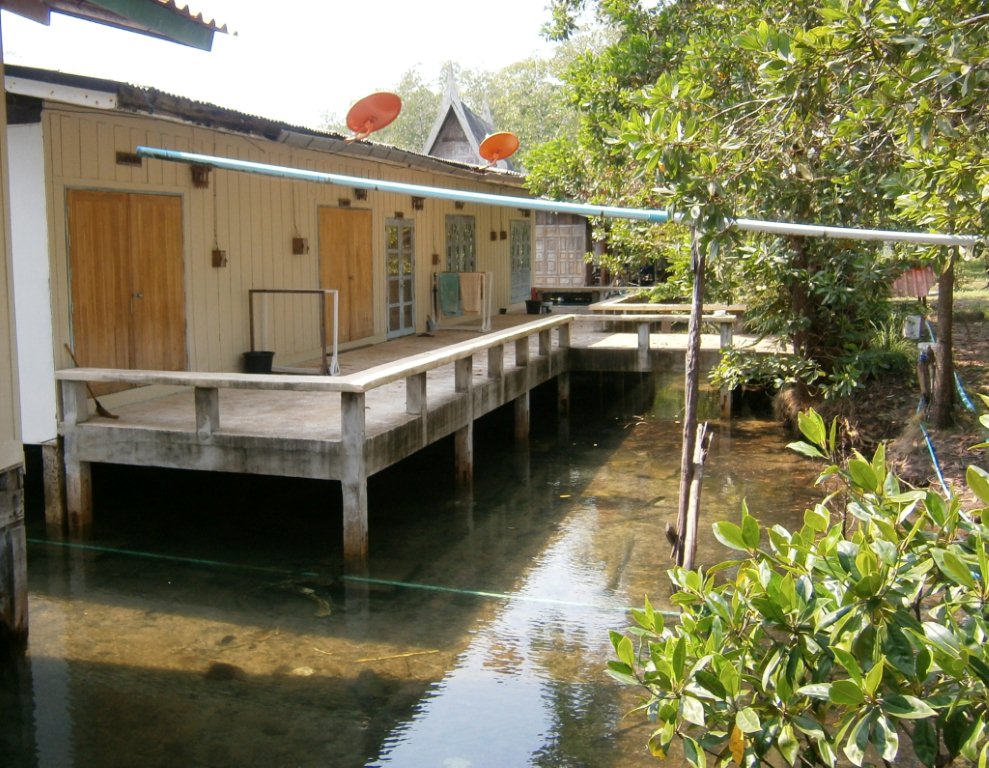
 But wait, there's more! I found this great shot on Wikepedia. They say it shows riverside housing but locals can't afford to put their houses on pontoons. Looks like the joint was a backpacker standard rafthouse some time in the past. Note nearest raft looks to have a restaurant deck. Note too the low level of the river (mud at bank-side) - maybe shot in time of drought. I noticed river would fluctuate a small 150mm or so during the day, highest mid-morning. A fellow guest told me the big dam upriver lets extra water out each morning.
 I wonder how high the river gets and how fast it flows at the peak of wet season?
This shot expands hugely if you click image on the Wikepedia page linked above - expands less on this page.
If you see mistakes or have extra information, please post below. If you have a question, please ask it on THE FORUM accessed thru the index link top right of page. I seldom check individual pages this far down but I try to monitor the Index daily when not travelling.
BACK TO BEACHES AND ISLANDS INDEX


 …that the falls don’t run too well in dry season. But unusually it rained EVERY night (and briefly on two days) in my dry season February 2008 fortnight in the eastern Gulf and so a good flow was going over, as can be seen here…